
-
 8619 Hits
-
 74.01% Score
-
 4 Votes
|
|
Mountain/Rock |
|---|---|
|
|
39.78668°N / 105.05642°W |
|
|
Denver |
|
|
Hiking |
|
|
Spring, Summer, Fall, Winter |
|
|
5415 ft / 1650 m |
|
|
Overview
 Historic Gold
Were it not for the gold discovery, who knows when Colorado would have been settled. Certainly not in the 1850's, and who knows what that would have meant for statehood. Because of the gold discovery less than a mile from the summit, pioneers made Colorado the second big gold rush, after California.
Inspiration Point celebrates that discovery. Thankfully, some folks in Denver had the foresight back in the day to not plat the summit into houses, and kept it as an open space park. Denver Mountain Parks, part of their Open Space plan, is one of the oldest in the nation, starting back in 1910.
The park has a few hundred yards of paved trails, and a scenic view of 200+ miles, easily spanning from north of Longs Peak, west to the Continental Divide and Mount Evans and south to Pikes Peak.
Inspiration Point
 Paved trails, scenic views.
Elevation : 5,415'
Counties : Denver
Quad : Arvada
Coords : 39.7869°N, 105.0592°W
Rise : 60'
Stats courtesy of ListsofJohn.com
Getting There
Metro Denver:The basics: you eventually need to get to I-70 and Sheridan, same vicinity as Lakeside Amusement Park.
Get on I-70, and take it either east or west, depending on where you're coming from. From westbound, simply turn right and head north to the next intersection and turn left (west). This is Inspiration Point Park.
From eastbound, you have to exit Harlan, turn left and go under I-70, head east to Sheridan, and either turn up one of the neighborhood streets and park at the base of the park, or do some terrible dangerous drive/maneuver to turn left/north onto Sheridan, and immediately turn left (west) into the park. Safer to park at the bottom of the park from the neighborhood.
From wherever you park, the summit plateau is clearly evident. Take the time for a short stroll and walk around the park, enjoy the view. Best viewed during sunrise and sunset.
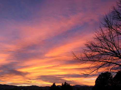 Spectacular.
 Red Tape
While not difficult, this probably isn't the best place to be during the night. I'd guess that while relatively safe, some nefarious dealings take place late here at night.Other knowledge
As you can tell on the plaque, the first documented gold find (by panning) in Colorado was less than a mile away from the summit, almost due north. The gold was found about 1/2 mile up Ralston Creek from the confluence with Clear Creek.