
|
|
Route |
|---|---|
|
|
47.91595°N / 121.06177°W |
|
|
Hiking |
|
|
Spring, Summer, Fall, Winter |
|
|
Half a day |
|
|
Easy to moderate |
|
|
Overview
From Irving Pass Trail originates the route of least elevation gain and most viewpoints of any major route leading to Poe Mountain. This summit route actually combines two major trails, Irving Pass Trail #1545 and Little Wenatchee Ridge Trail #1523. The route steeply climbs to Irving Pass before following the top of Wenatchee Ridge the rest of the way.NOTE: This route can be found on Green Trails Map #144.
Route Description
 Irving Pass Trail
The trailhead (4200’ elevation) for Irving Pass Trail is located near the end of Forest Road 6504. Irving Pass Trail steeply switchbacks up through a thick evergreen forest along the southwestern side of Wenatchee Ridge for approximately 0.7 miles, ending at Irving Pass (4900’ elevation). This marks the intersection with, and beginning of, the Little Wenatchee Ridge Trail to the left (heading west).
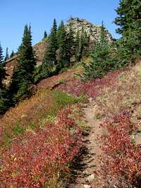
Follow Little Wenatchee Ridge Trail steeply uphill to the top of the ridge. After approximately 1/4-mile along Little Wenatchee Ridge Trail, the trail splits. The trail to the left continues along the ridgetop to Poe Mountain, while the trail to the right heads down to Cockeye Creek and rugged camping areas. Within another 1/4-mile, far-reaching views start becoming prevalent along the trail. From here, the area surrounding the trail also changes, from thick forest to alpine meadows and boulder outcrops.
 "The Bump"
Little Wenatchee Ridge Trail splits after approximately 2.0 miles. The trail to the left leads downhill along the western side of the ridge, eventually meeting the junction with the final summit trail for Poe Mountain after approximately 1/4-mile. The trail to the right leads uphill to the top of “The Bump”, a 6000’ hill considered by many to be a false summit or secondary peak of Poe Mountain. This trail leads to and from the summit of “The Bump” before rejoining the main trail at a saddle connecting the hilltop to Poe Mountain.
 Summit Trail
The intersection for the summit trail is unmarked and leads up the mountain, to the right. The main trail, in contrast, continues straight, becoming Poe Mountain Trail #1520 after this trail junction. The summit trail steeply winds approximately 1/4-mile around the western and northern side of Poe Mountain before reaching its rocky summit (6015’ elevation). Only several small remnants, such as metal cables, remain from a long since vanished lookout. Unobstructed scenic views are available in every direction from the mountain summit.
Getting There
Driving Directions to Irving Pass Trailhead (Trail #1545), westbound from Leavenworth:1) From Leavenworth, follow Highway 2 westbound for 15.3 miles to Highway 207 (approximately MilePost 84.7).
2) Head north (right) on Highway 207.
3) After 11.5 miles, continue straight through a gate. This is the beginning of Forest Road 65 (FR-6500). An “End of County Road” sign is located at the gate.
4) After 7.0 miles, turn right onto an unpaved/ unmarked road. This is the beginning of FR-6504.*
5) Follow FR-6504 for 6.1 miles to the trailhead/ end of the road.
*NOTE: An alternate route to FR-6504 is to continue on FR-6500 for 3.8 miles beyond the first FR-6504 turnoff, to where the pavement ends, and then turn right onto an unpaved/ unmarked road. After 1.3 miles, the road meets FR-6504 at a “T” intersection. Turn left onto FR-6504 and follow 3.1 miles to the trailhead/ end of the road.
------------
Driving Directions to Irving Pass Trailhead (Trail #1545), eastbound from Stevens Pass:
1) From Stevens Pass, follow Highway 2 eastbound for 4.0 miles (approximately MilePost 68.6).
2) Turn left and cross the (divided) highway onto Forest Road 67 (FR-6700).
3) Follow FR-6700 for 12.6 miles to its end, at the intersection with FR-6500.
4) Turn left onto FR-6500.
5) After 2.3 miles, turn right onto an unpaved/ unmarked road. This is the beginning of FR-6504.*
6) Follow FR-6504 for 6.1 miles to the trailhead/ end of the road.
*NOTE: An alternate route to FR-6504 is to continue on FR-6500 for 3.8 miles beyond the first FR-6504 turnoff, to where the pavement ends, and then turn right onto an unpaved/ unmarked road. After 1.3 miles, the road meets FR-6504 at a “T” intersection. Turn left onto FR-6504 and follow 3.1 miles to the trailhead/ end of the road.