
-
 13801 Hits
-
 72.08% Score
-
 2 Votes
|
|
Route |
|---|---|
|
|
37.56660°N / 90.7333°W |
|
|
12-13 mile hike one-way |
|
|
One to two days |
|
|
Walk-Up along Ozark Trail |
|
|
Approach
I thought I would add this route as a challenging alternative to those who would rather not take the easy route to the summit of Taum Sauk Mountain. This route follows the Ozark Trail and starts at the Johnson Shut-Ins State Park trailhead. To reach the park travel north on SH 21 from Arcadia or south from Potosi. Head west on SH N for over ten miles to the well signed park entrance on the left.
Arrive early on hot summer weekends to avoid having to wait to enter the park. The park restricts capacity to prevent overcrowding as the Shut-Ins (rocky section of river with pools and cascades that make great swimming holes) are popular with swimmers. The best time to do this route is in the spring or fall with the end of October providing some of the best fall colors in the country.
Call ahead or check in at park headquarters to assure you park in an overnight spot as this route requires a long 12-13 mile hike or overnight backpack with a car shuttle. They can also direct you to the Ozark Trail trailhead to access Taum Sauk Mountain. A very good trail map as well of tons of other useful information is available from the Ozark Trail Council.
Route Description
This route should not be attempted without first visiting the Ozark Trail Council web site and reviewing the Taum Sauk Section.
With a few short off-trail side trips, this route actually allows you to summit two additional 1,700 foot mountains between Johnson Shut-Ins State Park and Taum Sauk Mountain State Park.
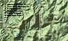
From the trailhead the trail initially crosses the East Fork of the Black River and heads north before heading east along a smaller drainage. That's the end of the crowds. The route then begins to switchback up to the top of the lesser southwest summit of Proffit Mountain at 1,656'. As shown in the attached topo map, the trail then follows along the southern slopes of Proffit Mountain for several miles. A short side trip will bring you to the broad summit of Proffit Mountain at 1,720' near a large powerline (yuck!). The views from up here are quite impressive as part of the summit is covered with rocky glades and thin tree cover.
A more strenous bushwack is possible east from the east slopes of Proffit Mountain to the summit of Wildcat Mountain (over 1,760' but considered part of Taum Sauk Mountain). This requires decent route finding skills, not only to find Wildcat Mountain, but to find your way back to the Ozark Trail or cross country along a broad saddle to Taum Sauk Mountain itself.
If you continue east along the Ozark Trail from Proffit Mountain you will eventually drop down to Taum Sauk Creek. After crossing to the south side of the creek, the trail turns east upstream and eventually comes to a nice feature called the Devil's Tollgate through which the trail passes.
Once beyond Devil's Tollgate, the trail continues upstream to the base of Mina Sauk Falls. The trail heads up and around the falls and on to the summit of Taum Sauk Mountain and the Taum Sauk Mountain trailhead. Just before you come to Taum Sauk Falls, Taum Sauk Creek branches. The east branch heads up to the falls. The north branch is a nice side trip bushwack that passes a 10'+ waterfall and some nice shut-ins and eventually climbs to the west slopes of Taum Sauk Mountain. Finding the summit and trail system from this bushwack requires decent route finding skills.
 |
Essential Gear
This route makes for a long day hike requiring a car shuttle. Both trailheads are 2 wheel drive accessible. This would make for a great overnight backpack with car shuttle in the fall. Probably one of the best overnight trips in the Midwest.
Although the trail is well marked with the distinctive OT green and white markers, a map and compass should be used on this route, particular if you chose to try any of the bushwacks/sidetrips.