
|
|
Route |
|---|---|
|
|
80.35646°N / 93.16781°W |
|
|
Hiking |
|
|
A long day |
|
|
Overview
Why Judean desert? Five years ago I was looking where to go for rehabilitation after hart attack. Dead Sea, with its 3 extra % of oxygen in the atmosphere seemed to be a right choice. So my wife and I came to Ein Boqeq (Israel) in January 2010. One day we unexpectedly came across hiking trail to wadi Boqeq…. But only two years later we ascended Mt.Boqeq and other summits in Ein Gedi and Masada regions. 4 years latter in summer 2013 I already ascended 3000 m summit with 1000 m elevation for 4,5 hours. After this summer ascent I wanted to finish 2013 with another significant result. To my mind it could be a new “out of trail” desert route in Judean Desert.
Hiking in the "wild desert” essentially differs from the marked trail hiking. After 4 years practice it seemed to me that I accumulated enough experience and health to try a new route including quite extended “out of trail” part in Ein Boqeq region.
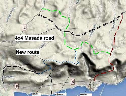 Hiking routes in Ein Boqeq Region | The route from road 31 to road 90 through Mt. Boqeq is the main hiking route in the region. The route consists of two trails: “green” trail from road 31 to Mt Boqeq and “red ” trail from Mt Boqeq to road 90 and Dead Sea coast. There are no any other marked trails from the coast to the desert plateau except this trail
While descending through Nahal Rohm year ago, I noticed not marked trail rising in the direction of the plateau. So I could think that there should be the way to the plateau through the rocky belt of Mt Rohm. I got an idea to get to the plateau using this trail and then try to find a way to the “green” trail and Mt Boqeq. Thus in the case of success we could have a new route in the region. I didn't find any reports on passing the route on Israel tourist sites. It warmed up interest and desire to do it. |
During our next visit to Ein Boqeq in December 2013, we made an attempt. And it was successful. The route turned out more interesting, than it was possible to assume. We lost the unmarked trail some were in the middle of the way to the plateau. I think that the trail is very old and it is impossible to identify it among numerous animal trails wich you can see after you cross first rocky belt. So more than 3 hours we were looking for the way on quite difficult for orientation mountain and desert terrain and, eventually, safely got to the “green” trail and Mt Boqeq. Then we descended to Ein Boqeq by the standard “red” trail. We didn't use a navigator or compass, and were guided in the old manner by the Sun and shadows. And it was delightful. The route took us 8 hours, its extent is about 15-16 km, total elevation about 700 m, air temperature reached 32 C in the afternoon .
Getting There
From Ein Boqeq move 2 km to the South by the sea embankment to Nahal Rohm (A stone with black marking near the road).Route Description
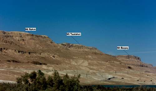 Rohm-Tsalahot-Boqeq massive. View from Dead sea | Mt Boqeq from the South through Nahal Rohm From the Dead Sea embankment move Up through Nahal Rohm(black marking) to the pass in the Mt Rohm SE ridge. About 1,5 hour from Ein Boqeq (See Judean desert route №1). In the rains period there can be water in Rohm's canyon. One small bathtub should be passed on water (slightly over the knee). |
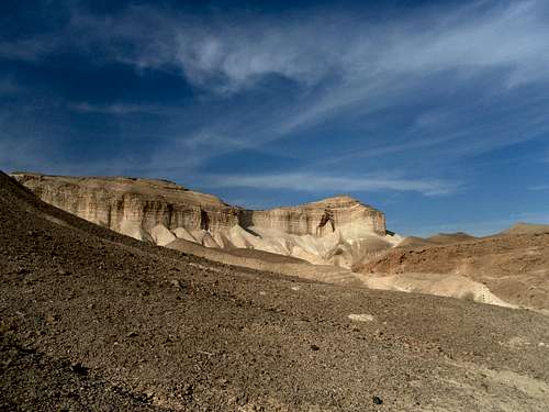
Near the pass look for unmarked trail in the North-West direction. By this trail cross a rocky belt and move further along a soft stream mainly to the west, to the pass in the main crest of Rom-Tsalahot-Boqeq massive. From the beginning of not marked trail 1,5 hours. | 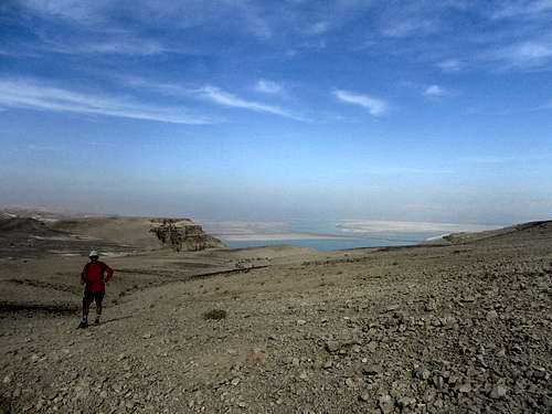 Desert plateau between Rohm and Tsalahot |
 Desert view near Mt Boqeq | From the pass move to the North along the west slope of Mt.Rohm to the plateau between Mt Rohm and Mt Tsalahot. On the plateau continue to move North in the direction of Nahal Tsalahot escarpment. From Nahal continue to the north and ascent Mt. Tsalahot summit plateau. Cross plateau up to the edge of Boqeq canyon. View point! Then along the canyon edge to the West and then descent SouthWest by the rocky gulley. “Green”trail is about 100 m to the West from the gulley bottom. In total from the “black” trail in Nahal Rohm 3 – 3,5 hours. Then by "green" trail to Mt Boqeq and to Ein Boqeq by "red" trail. |