
|
|
Route |
|---|---|
|
|
35.85694°N / 89.57778°E |
|
|
Mountaineering |
|
|
Expedition |
|
|
High altitude snow climb |
|
|
Overview and short history
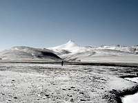
 Still 40km away
Kangzhagri, a.k.a Kung Oscar II Fjäll, is located in eastern parts of the Chang Tang plateau. It's very heard to reach the peak and there are probably only two more 6000 meter peaks which are as hard to get to. Those are Rola Kangri and Kukushili. A Japanese expedition finally made it to the area in the winter of 1998/1999, but failed to reach the summit due to the severe cold of the winter. Frost bite, low temperatures and high winds stopped them. They finally reached the summit of Kangzhagri's east summit, the lower Kangzhagri East a.k.a Kangzhagri Qinghai, which is located about 25 km away.
Corax and I planned to climb Kangzhagri in 2003 and got close to it, but exhaustion from the over 3 weeks in the wilderness made us call off the attempt without even trying. Ola Skinnarmo, a Swedish adventurer staged a major expedition in the spring of 2007, but had to give up far away from the mountain.
Later the same year Corax and I made another attempt and this time it ended in success.
Kung Oscar II Fjäll is the name famous explorer and cartographer Sven Hedin gave the peak in 1896 when he saw the mountain. He was sponsored by the late Swedish king Oscar II and thought it was a suitable name to honor his sponsor and king. The name stayed on many maps until the 50's, when the official Chinese name took over.
Getting There
 Getting closer, about 20km to go Getting closer, about 20km to go |
 Marmot, salt lake and Kangzhagri Marmot, salt lake and Kangzhagri |
 Cold evening sunset over the plateau Cold evening sunset over the plateau |
It's extremely hard to reach the peak at all. Motorized expeditions have to deal with huge rivers, difficult mountain passes, mud fields and the fact that there's no help for weeks if they get stranded. We encountered a full scale prospecting crew armed with the most modern vehicles which didn't make much progress. They were defeated by the large mud fields even if they had four brand new Komatsus to force their way through with. Still, they all got hopelessly stuck and the whole expedition had to turn back.
Under perfect conditions it may be possible to reach the peak with help of specialized vehicles, but the chances are slim.
We choose to go by our bicycles and it took us 27 days to reach the mountain. We mainly pushed the bikes and rode some when on frozen ground or trails made from the prospectors. When we reached the central parts of the Hoh Xil/Kokoshili Range it made no sense to continue with them as the topography was too difficult and we walked with provisions for 15 days towards Kangzhagri.
 Early morning on the way up.
Route Description
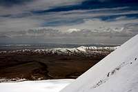
From what we saw, there's only one straight forward route to the summit. All other lines are full of difficulties with sharp ridges, large cornices and crevasse filled ice falls.First you have to cross a sub range in the west. There are 3-4 passes over the range which are negotiable. When at the foot on the western side you can see a distinct red colored sand peak. Go south of it. There are a couple of ridges on sand and gravel which take you onto the snow fields without too much difficulty. There's a broad snow covered "pre-summit" ahead of you when you're on the snow. Pass it on the south side or you have to deal with crevasses. We stayed high on the southern slope on this little peak. When you come around the corner of it the main summit of Kangzhagri is fully visible.
 At the foot At the foot |
 Seeing the last part Seeing the last part |
 Before the steepest part Before the steepest part |
It's a good idea to rope up before arriving at the saddle because there are quite a few small, and possibly bigger crevasses on the saddle and also on the way up towards the summit.
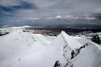
Continue on the close to the north side of the ridge towards the summit. It's a straight forward walk/climb to some steeper sections below summit. You may be tempted to steer off to the right and traverse, but it's not a good idea as it gets really steep on the last part chosing that alternative. Better just go straight on along the ridge and deal with the 45 degree "crux". When it flattens out slightly you walk on the right hand side below a huge cornice. Better stay close it as it drops steeply on your right and the snow was unstable when we were there.
The summit is a small platform of rock with a an overhanging cornice in the south east. Underneath a small pile of rocks you will find a hand made Swedish flag from our first ascent.
Photos many times lie.
When we saw the peak from far away, the last part looked really steep and that's also what the photos show. When close by it looked like a very low gradient climb and again, that's what the photos tell you. Reality is somewhere in between.
 Corniced ridges Corniced ridges |
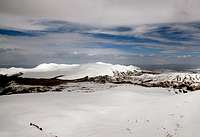 Kangzhagri East Massif Kangzhagri East Massif |
 On the way down On the way down |
Essential Gear
Climbing gearExpedition gear
The list can be made long, but expect to take care of yourself for weeks in total wilderness and equip youself according to that.
 On the way out. A yak blocking my way.