Some points that are either new or I have not seen covered in other trip reports before I get to more general comments on the trip. If you are not on a very well maintained trail after the Koaie Camp [N22.11270 W159.56204] you are on the wrong trail. There are a set of pink and faded pink flags that take you in the wrong direction (To the left). On the correct trail logs have been laid to function as steps and stop erosion. There is even a metal ladder in one part with some webbing to grab on to. We had to hop the hog fence twice. The second hop occurs after one of the steep climbs along the fence. There seems to be a new fence, at least twice as tall as what you’ve encountered so far. Plastic netting is used to give it its increased height. The new fence goes off to the right. Currently there is a bright orange shirt tied up high. We climbed around the new fence which involved hoping over and the old fence twice as to keep it on our left. The Kauai Revealed app was well worth the 9 dollars I paid for it. Both for general use on the island and for making sure we stayed on course on the drive in and on the trail. As of March 28, 2016 it appears that the app has the most up to date trail. Two caveats, it does not have the route all the way Kawaikini; the route in the app takes you to the end of the hog fence and then to the Ka'awako Heiau north of the summit. The point marked “Kawaikini” is not the actual summit (more on that later). The video starts looking at the summit:
Getting there
Just past the turn off for the Koke’e Natural History Museum (on the left, north) take a right at the sign to Camp Sloggett the YWCA camp. On Google maps the road is called Kumuela Rd. [22.129186, -159.656790]
In other descriptions you’ll see it described as the Mohihi-Wai’alae Trail head, 6 mi. (9.66 km) from the Koke’e Museum at the end of the Mohihi-Camp 10 Rd. Looking at google maps it may look like you should take the next right [22.130806, -159.653717] but I did not find this to be the best way. Currently there is an orange cone at turn (Also visible in Google Street view). That road splits three ways. The right and left appeared to go to private property and the middle was heavily overgrown and seemed to turn into more of a trail than a road. The Kauai Revealed App worked very well for keeping on course. I would strongly suggest a 4x4 and I’m not afraid to hammer a car on a dirt road. I saw some locals driving the road in a car; there was literally a kid sticking out of the window lying over the roof trying to adjust where his weight was to keep the bottom of the car from hitting rocks and bottoming out. A 4x4 is just going to remove a whole lot of stress from your life. Ruts and potholes can be deep and there are stream crossings. If it rains hard you may not be coming out for awhile even with a 4x4.
Times
Time
Place
Running Time
Time Between Landmarks
Breaks
4:42
Started
7:11
Kokaie Camp Stream Crossing
2:29
2:29
30-60 min. Lost
9:38
Start of Hog Fence
4:56
2:27
30 min. First Aid
12:40
End of Fence
7:58
3:02
14:07
Arrived at Summit
9:25
1:27
15:12
Departed Summit
10:30
1:05
15:52
Rain Gauge
11:10
0:40
23:12
Returned to Truck
18:30
7:20
30 min. Pumped Water
Don't get lost, don't get hurt, don't spend so much time at the summit and you shave off 2 hours which would put you faster than Bob Burd's time of 17:15 (he didn't have the luxury of a complete fence from Sincocks to the Rim). Rob Woodall estimates a fast hiker could do it in 14 hours with the fence. Maybe I don't realize how slow I was moving but shaving 2 hours off of Simon and my no mishaps time seems pretty fast to me. I could be underestimating the speed boost from having more daylight. You'd also need a dry day and be speed hiking most of the trip to do it in 14 hours in my opinion. Doable yes, but I'm not sure I'd make 14 hours a goal unless you're approaching an elite level. My speed pride left me long ago so feel free to prove me a slow hiker.
Gear
Deuter 40 liter pack 4 liters of water (plenty for me, Simon had 3 litters and then drank one of mine and had to pump more) Water filter, Black Diamond 3 watt LED headlamp, 4 spare lithium ion phone batteries, (Went through all of them between Simon and I) Small Emergency kit, 8 AA batteries for headlamp (none used), Sunscreen, Bug Spray (not needed), 20 dollar Speedo water shoes I picked up at Lihui Costco, lightweight Smartwool socks, REI travel pants, a lightweight running shirt, with the Marmot Precip Rain Jacket when it was cold or raining. I highly recommend pants and a long sleeve for this trip as we got very scratched up by the ferns. I used a garbage bag as a rain fly for my pack.
In case I had to spend the night: Emergency Poncho, Patagonia midweight base layer bottoms, Polartec stretch fleece.
Food
Apple, Tangerine, 3 oz. Bag of jerky (½ consumed), Kirkland Trail mix (1 pint ziploc bag ½ consumed), Harvest valley Granola Bar (took 2 ate 1), Clif bar (took 2 ate 1), Also had a a few crackers that Simon shared with me.
My Fitness
I had not been working out regularly. I have a desk job where I sit. I stand when I am at my computer at home. I was bouldering about every other week. I did the 8 mile round trip hike to Hanakāpīʻai Falls on March 21, 2016 seven days before this hike. I did a 2 mile run on the beach along with increased walking of the trip. Bottom line is that my fitness was nothing special but it seems that my out-of-shape is most people’s in-shape. It had been a couple years since my last big hike/climb where I had been having trouble with altitude sickness.
A big thing that I draw from this is that things drain out pretty quickly. After 8" of rain you only need a day or two for things to become manageable. Things were fairly dry for my stay in Hawaii. Looking back a week precipitation was low except for March 24 and 25 which had 5” and close to 3” of rain. On the evening of the 27th the road was dry in many places. On the 28th .1” of rain was recorded.
Background
My family decided on a whim to do a Hawaii trip and I wanted to find a hike. Why do Kalalau when you've got Kawaikini? Ok, I couldn’t get a permit (though Simon did do both and he liked this hike better). I looked into summiting the highest point on the island and was surprised to see that it was a rather rare endeavor. After some research, I decided I would probably not do the hike because there was just a little too much to this trip, especially since I was likely going to be doing it solo. I downloaded the Kauai Revealed app for general use on the Island and saw an entry titled "Visit the Summit of Wai'ale'ale". The app allows one to track one’s location on the trail via GPS. This removed almost all my trepidation and after meeting Simon, a constantly barefoot Québécois, during a couchsurfer pot luck the trip seemed like a no-brainier.
General Comments
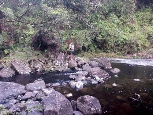
Check out some of the other trip reports for more detailed trail descriptions. I’ll link to some at the bottom even though I’m sure you can find them on the main page. The trail ranges from “I’m just going to sprint down this” to no trail. There was very little what I would call bushwhacking as long as you stay on the trail. There is trail to the fence, space on the side of the fence, and then when the fence ends you are walking on grass and moss sitting on a few centimeters of mud. I can't speak if it's rained a few inches but I did not find travel along the summit ridge to be taxing. We did not technically park at the farthest point one could drive. We stopped near a picnic shelter and some trash cans. We got to the picnic area around 20:30 at night and put up a tarp over the back of the pickup to sleep. This worked out very well and we were probably in our sleeping bags around 22:00. There was light rain during the night. Starting at 4:42 we hiked down the road/very wide trail and crossed a footbridge to another picnic area. The best description of the first part of the trail I’ve found comes from Rob Woodall on Peakbagger: “The trail is initially vehicle width although steep and muddy. We soon reach a T junction. The foot trail goes straight across, passing close to a shelter N22.11727 W159.60174, descending to cross a small stream N22.11692 W159.60127.” The stream was easy to cross, plenty of rocks to walk on. Though I could see there being trouble if it rained heavily. We hiked in the dark for a couple hours, and never got off course. Whenever there were two possible directions I always chose to go “up” which usually meant staying to the left. The hardest route finding before you get to the next stream crossing is caused by ferns that obscure the trail. We passed the bench (at the time not broken as described in some descriptions) [N22.10973 W159.59350] further there are two poles where the old weather station used to be. The descent to the Koaie Camp is steep but nowhere did I feel nervous. A ~10 ft. length of green tubular webbing with knots has been added in one spot . I found a ziploc bag of the webbing stashed a few miles down the trail in a tree hole.
Stream crossing to the Koaie Camp
We lost the trail after Koaie Camp Cabin, there were two sets of ribbons (Pink and faded pink) that led us off trail to the North bushwhacking through thick ferns. The trail is good after Koaie Camp and has been maintained. Logs have been laid to function as steps and stop erosion. There was even a metal ladder in one part with some webbing to grab on to. Once again pink flags could meander a bit and led us into the deepest mud we encountered. Sadly I put a flag up here to mark the way we went through the mud. Please remove it if you see it to keep other from going astray it is labeled with two sets of initials and 2016-03-28. Unfortunately in the dark I passed it. The arrow [N22.09143 W159.55116] at the trail intersections was easily visible. And as soon as you head down the trail there is an abundance of flags. Yellow and Blue were more intermittent but I took those be a sign that we were on the correct path. I didn’t fully trust some of the pink flags but they never took us off course as badly as before. There were also striped flagging as well and some flagging that was almost white with age. Simon enjoyed the hopping and ducking over logs on this part of the trip (even on the way back). This is where things would probably get very trying with a heavy pack. Keep following the flags and then you’ll abruptly pop out at Sincocks bog. The now almost entirely faded traffic cone is still there.
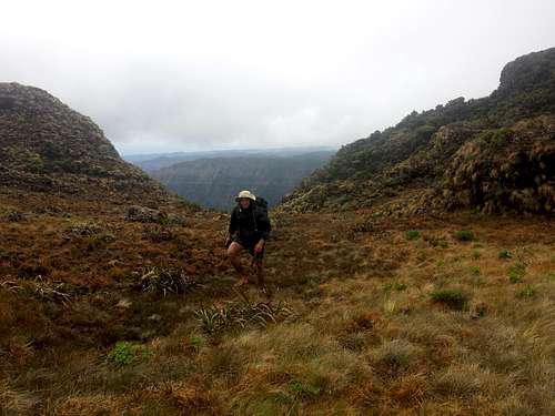
In some trip reports they talk about walking on the fence that has been laid on the ground to keep the hogs from digging under. I would recommend avoiding this when at all possible. Where the fence has been pushed into the mud it is now rusting and beginning to break. Rusty shards now protrude in many places. As mentioned in many descriptions there are the steep points where people use the fence to climb. It seems like it’s holding up pretty well but I did notice one of the steaks had come loose could be moved. So be wary as time goes on. If this trail was maintained I think ropes for these sections would be advantageous. Simon who was doing the hike barefoot (yes, you read that right) got a rather large sliver in his foot and I had to cut it out with a knife. A little duck tape and he was good to go. We got to the end of the fence and a stile. It was cloudy, windy, and lightly raining. I got disoriented and could not remember exactly how to proceed. I knew the app’s trail did not go in the direction of the summit and I was unsure of the terrain. “Could I just follow the ridge or was it more complicated than that?” For the record It’s not more complicated than that.
Looking at our phones we got confused. We began unknowingly slowly drifting away from the ridge and into the swamp. We almost abandoned the summit attempt, but with some clever way point dropping on Google maps we started to regain our bearings. Then something remarkable happened, the clouds began to dissipate and we saw a deep valley.
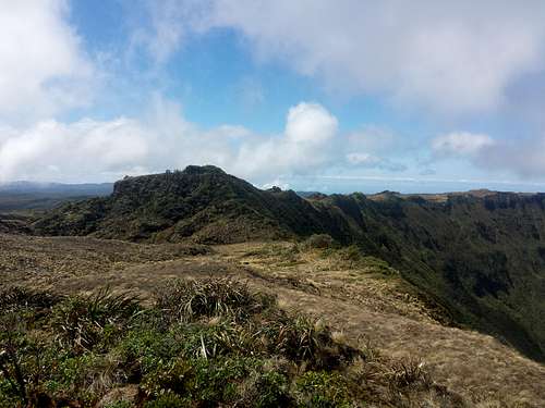
To the west it began to clear and all fatigue faded as the vistas began to unfold around us. I giddily ran to the edge of the Blue Hole, snapping picture and video. I looked up and saw what had to be the summit area. Our progress was fast and the clouds kept dissipating around the island. The sun came out. We stayed in the summit area for over an hour. I’m probably one of the few people that have gotten a sunburn in “the wettest place on earth”.
In a full resolution image you can see the fence going down into Blue Hole.
Ridge looking at the summit on the south. In a full resolution image you can see the fence going down into Blue Hole.
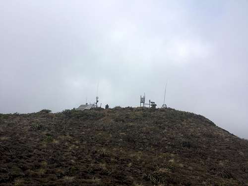
I have a lot of great shots of the summit but they are all from the south, which is not the side you want to approach from. Handily the approach from the North is very straightforward; class 3 max in my opinion. Thankfully I wasn’t going to spend over 9 hours with wet feet and not make sure I made it to the summit so as we were hiking back I quickly ran to the top of a point that I thought looked like it just might be higher than everything else. Since I didn't take it I won't post the picture here but here is a link to the best shot of the South Face of Kawaikini I've come across. Just some more videos of the area Clear Views from Near the Top of Waiʻaleʻale Travel back to the fence was very easy now without fog. Clouds had started to come back but visibility was still good. Only right before we got to the fence did visibility begin to decrease. Simon could tell I was disappointed that we couldn’t see the rain gauge and would likely not be making the exploratory journey to find it. But as we had turned and started heading back down the fence the fog parted for a brief moment and we saw the gauge surprisingly close. We hopped the fence and quickly made it to the weather station.
Not much to say after that. Visibility was better on the way back than on the approach, but we had to do much more of the hike in the dark but only briefly got off trail a few times. It rained for our last few miles. If you are hiking in the dark and the sky is clear turn off your headlamp and take a second to take in the stars. We got back to the truck took down the tarp we had put up, and had a wet but relatively uneventful drive back to the Koke’e museum. We laid the seats back and slept in the truck for a few hours.
Where is the summit?
I you are using standard GPS, topo maps, compass and some of the other trip reports it’s probably not a question for you. (September 2022 update: Newer topo maps (2013, 2017) don't seem to show as many details as past versions (1991 and older)) When you hodge podge your trips like I do you might have some problems. So if you aren’t like me you can probably skip this section and this will likely be irrelevant as I’ll be seeing what I can do to get things standardized. The point I had in my phone was from wikipedia: WGS 84 22° 3′ 24″ N, 159° 29′ 48″ W | 22.056667, -159.496667 Summit post has the location as: Lat/Lon: 22.06200°N / 159.5°W Granted when you click on it is says “near” so fair warning. PeakBagger appears to have the most accurate: 22° 3' 31'' N, 159° 29' 50'' W | 22.058591, -159.497337 (Dec Deg) | 448685E 2439396N Zone 4 (UTM) I couldn’t get the lat/lon from the Maui Revealed App (if it’s even possible) but there is “Kawaikini” with a little line and 5,209’. Well if you’re paying attention then you should immediately know that the summit is not 5,209 ft. (1,587.7 m) but 5,243 ft (1,598 m). My memory was not that good so I spent most of my time in a lovely area for taking pictures but not actually at the summit.
Image from Kaua'i Revealed
Various points mapped on Google earth
Northern star: Summit Post. Southern Star: Wikipedia. The Google mountain marker and what seems to be the correct point. Just to the right is the location from PeakBagger
Parents refers to a larger category under which an object falls. For example, theAconcagua mountain page has the 'Aconcagua Group' and the 'Seven Summits' asparents and is a parent itself to many routes, photos, and Trip Reports.


Comments
Post a Comment