
-
 27994 Hits
-
 93.1% Score
-
 41 Votes
|
|
Area/Range |
|---|---|
|
|
48.59568°N / 118.47931°W |
|
|
Hiking, Sport Climbing, Bouldering, Aid Climbing, Mixed, Scrambling, Skiing |
|
|
Spring, Summer, Fall, Winter |
|
|
7000 ft / 2134 m |
|
|
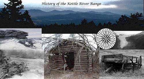
Overview: The Kettle River Range
The Kettle River Range is a series of mountains in southeastern British Columbia, Canada and north-central Washington state, United States. The Kettle River Range (often referred to as the Kettle Range) is a subrange of the Monashee Mountains, which in turn form part of the Columbia Mountains.
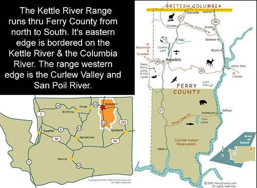
The Kettle River Range runs primarily north to south. Bordered on the west by the Kettle River, the Curlew Valley and the San Poil River and to the east the Kettle River and the Columbia River. This range of mountains originates just north of the Canada / U.S.A. border and runs south to terminate at the big bend of the Columbia River (Lake Roosevelt) at it's southern extremity. This sub-range of the Monoshee Mountains dominates Ferry County in the state of Washington.
At 7,123 feet (2,171.09 meters) above sea level Copper Butte is the highest mountain summit of the Kettle River Range. Copper Butte is located at the latitude of N 48.702393 and longitude of W -118.465292.
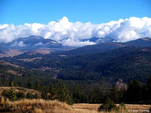
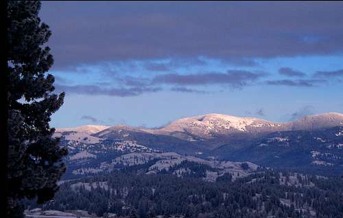
This image of the upper latitude of the Kettle River Range is representative of the northern reaches of this mountain group. Lowland forests and open meadows giving way to heavier alpine forests in the higher elevations.
In this image (left to right):
Scar Mountain ~ 7,024 feet (2,140.92 meters) located at latitude N 48.681004 - longitude W -118.460013
Wapaloosie Mountain ~ 6,942 feet (2,115.92 meters) located at latitude N 48.664337 - longitude W -118.463069
Columbia Mountain ~ 6,765 feet (2,061.97 meters) located at latitude N 48.62017 - longitude W -118.481959
Getting There
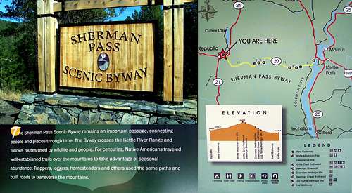
Getting there: Route 1 ~ The middle route; WA State Highway 20 between Republic and Kettle Falls:
From the west: the Sherman Pass Scenic Byway (WA state Hwy 20) starts in the small town of Republic WA. and travels east over the Kettle River Range through portions of the Colville National Forest. For 18 miles the byway climbs steeply to cross Sherman Pass, Washington’s highest year-round maintained pass at 5,575 feet above sea level. The views along the byway are open meadow ponderosa pine forests of the lowlands and cascading creeks and waterfalls, tumbling thru the western larch, Douglas fir stands. The upper elevations are given over to alpine firs and lodgepole pines. .
From the east: you’ll leave Kettle Falls, drive west on US 395. After crossing the Columbia River, and Franklin D. Roosevelt Lake at the historical site of the now submerged Kettle Falls, turn left just after the bridge onto SR 20 on the Sherman Pass Scenic Byway. It is about 18.5 miles to the crest of Sherman Pass.
The Kettle Crest Trail crosses SR 20 on Sherman Pass. There is a large parking area to the north off the highway. Nearby trailheads to go either north or south along the ridgelines.
Getting there route 2~ The northern route; Boulder / Deer Creek Road is a paved county highway crossing the Kettle River Range near it's northern area.
From the west: Depart the small village of Curlew located along the banks of the Kettle River. The county highway climbs to the east in a gentle route toward Boulder / Deer Creek Pass, which at 4,110 feet is over a thousand vertical feet lower than Sherman Pass. The distance from Curlew to the pass is approximately 14 miles.
From the east: Just south of the small town of Orient WA turn east off SR 395. This is the eastern end of the Boulder / Deer Creek highway. It is just over a steep, twelve mile climb from the river to the pass.
The Kettle Crest Trail crosses Boulder / Deer Creek Pass and offers routes either north or south.
There are a number of other trailheads taking off from county and forest roads within the range. I will update that info as this page develops. This is definately a "work in progress".
Red Tape

Colville National Forest
765 South Main Street
Colville, WA 99114
(509) 684-7000
External Links
Snow Peak CabinSherman Pass Scenic Byway
Ferry County WA, U.S.A.
Colville National Forest
Curlew Lake State Park
Stonerose Interpretive Center
Lake Roosevelt National Recreation Area
Republic WA U.S.A.
Grand Forks B.C. Canada
Kettle Falls WA U.S.A.
Colville Tribe
Camping

There are numerous camping opportunities within and surrounding the Kettle River Range.
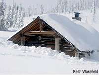
Many years ago a homegrown group of outdoor recreationalists known as the Kettle Range Ski Club, working in partnership with Republic Ranger District, and the Colville National Forest, developed a remote shelter in the Snow Peak east basin, now known as the Snow Peak Shelter. See below on how to reserve the shelter for your group.
Colville National Forest -- Republic Ranger District
As of December 2, 2009, the Republic Ranger District, Colville National Forest, no longer manages a lottery system for reserving the Snow Peak Cabin (also known as the Snow Peak Shelter). Instead, the District transitioned the management of its reservation system over to the Forest Service's contracted National Recreation Reservation Service (NRRS). Under the new reservation system, reservations can be made up to six months in advance of arrival and must be made at least one day prior to arrival. For a full list of reservation system fees and policies, please go to www.recreation.gov or call NRRS Reservations at Toll Free 1-877-444-6777. Whether on-line or over the phone, use the search function to look for: Cabins or Lookouts, Washington State, with a Facility Name of "Snow Peak Cabin".
The cabin use fee is $30 per night with a reservation transaction fee of $10 per reservation (charged by the reservation company). The maximum stay limit is five nights within a fifteen day period for each reserving party. The occupancy limit for the cabin is six people.
Scenic areas of the Kettle River Range...


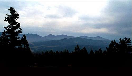
In the first image of this section is an early spring view of:
Sherman Peak ~ 6,886 feet (2,098.85 meters) located at latitude N 48.596559 - longitude W -118.477514
Snow Peak ~ 7,073 feet (2,155.85 meters) located at latitude N 48.581837 - longitude W -118.482236
This image was captured from WA State Hwy 20 near Wauconda Pass looking east into the Kettle River Range.
The Kettle River Range is a geologically old landmass of rolling mountains with seventeen peaks higher than 6,000 feet. During the last few ice ages this was heavily-glaciated terrain.
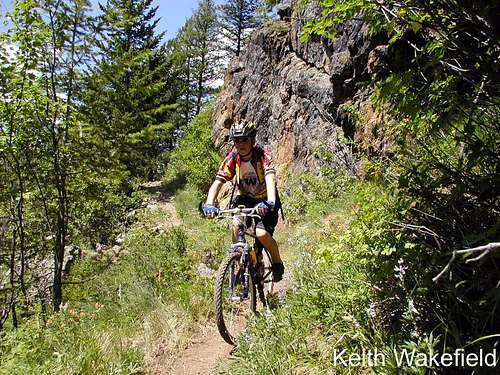
The range features a 45 mile-long Kettle Crest National Recreation Trail, which is a very popular route with hikers, skiers, horse-back riders and mountain cyclists.
Vulcan Mountain, 5,256 feet (1,602.03 meters) located at latitude N 48.989341 / longitude W -118.648922
The Vulcan Mountain landmass is a sprawling area encompassing approximately 100,000 acres. The mountain itself is unique in that it's peak is in the United State with it's northern slope in British Columbia Canada. Three of flanks of this mountain are shoreline of the Kettle River as the river loops into the U.S. from and then returns back into Canada. Vulcan Mountain is in the lower area of the Monashee Mountain Range, a foothill of the Kettle River Range.
At 7,123 feet (2,171.09 meters) above sea level Copper Butte is the highest mountain summit the Kettle River Range. This sub-range of the Monoshee Mountains dominates Ferry County in the state of Washington (WA). Copper Butte is located at the latitude of N 48.702393 and longitude of W -118.465292.
As evidence that this mountain range is part of a wildfire ecology Copper Butte bears the scars of many small fires and one large complex fire which occurred in 1994. Much of south slope of Copper Butte burned in that 11,000 acre wildfire that bore the mountain’s name. Now, over a decade and a half later parts of the mountain have regrown in thick copse of timber. On the summit there are several rock cairns mark the old lookout tower on Copper Butte. There is also the USFS Triangulation Station brass marker set in 1925.
This evening photograph looking across Franklin D. Roosevelt Lake to the Kettle River Range eastern foothills. Also called Lake Roosevelt this reservoir was created in 1941 by the impoundment of the Columbia River by the Grand Coulee Dam in Washington state. It is named for Franklin D. Roosevelt, who was President during the construction of the dam. The lake covers 125 square miles (80,000 acres), it stretches about 150 miles from the Canadian border to Grand Coulee Dam, with over 600 miles of shoreline; it is the largest lake and reservoir in Washington and home of Lake Roosevelt National Recreation Area. This lake borders the eastern foothills of the Kettle River Range for approximately 120 miles.
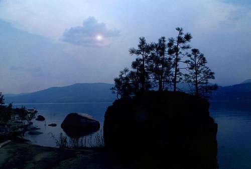
The image to the left is dawn on the Kettle River looking east to the Kettle River Range. The river borders the range on portions of three sides, west, north and east.
The Kettle River is a 175-mile (282 km) tributary of the Columbia River in southeastern British Columbia in Canada and northeastern Washington in the United States. The drainage basin is 4,200 square miles (11,000 km2) large, of which 3,177 square miles (8,230 km2) are in Canada and 1,023 square miles (2,650 km2) in the United States.
Nehi-alpit-qha is the native Salish name for this river. The archeological record shows human habitation in this area for approximately 9,000 years. The source of the Kettle River is the outlet of Holmes Lake in the Monashee Mountains of B. C. Canada. The river flows southeast to Midway, B. C. below which the river loops south into the United States, through Ferry County, WA, before flowing north back into Canada. At Grand Forks, B. C. the Granby River joins the flow. The Kettle continues east for 10 miles (16 km), before turning south a final time just below Christina Lake, and re-entering the United States. The flow continues southerly joining the Columbia River north of Kettle Falls, WA. The Columbia River at this point is a large reservoir impounded behind Grand Coulee Dam, called Lake Roosevelt. The Kettle enters the lake at the Columbia's river mile 706.
Wildlife and Environment


These big horn ewes bunch up for protection and will stick together throughout all seasons with their lambs in tow. This image was captured in the foothills of the western portion of the Kettle River Range.
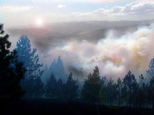
As mentioned in other postings the Kettle River Range is a fire based ecology. Historically major wildfires have burned across hundreds of thousands of acres within this mountain range. This is an image from the 2010 Fish Hatchery Fire started on Fish Hatchery Creek and burning in the western foothills of the Kettle River Range.
August of 1988 saw a dry lightning storm lift off the North Cascade Mountains and hammer it’s way into Ferry County. Over thirty wildland fires started and while most were suppressed by local firefighters two escaped containment and burned together across the ridgeline of the Kettle River Range. By early September the ‘White Mountain Fire’ was over 21,000 acres is size. This image takes in the sunset several years later thru some of the White Mountain fire snags.
Prominent Peaks of the KRR
Togo Mountain , 6,079 feet (1,852.88 meters) located at latitude N 48.934344 - longitude W -118.367239. Northern most of the ‘tall’ peaks of the Kettle River Range. Togo Mountain’s summit was scorched in a 9,000 acre wildfire in 2003. The fire started from a dry lightning storm and threatened the town of Grand Forks, British Columbia.
Profanity Peak, 6,414 feet (1,954.99 meters) located at latitude N 48.78434 - longitude W -118.430014. The lower southern slopes of Profanity Peak burned in the 2001 Mount Leona Fire. Firefighters managed to stop the blaze before it burned over the peak itself.
Mount Leona, 6,460 feet (1,969.01 meters) located at latitude N 48.767949 - longitude W -118.473349. The peak and all slopes of Mount Leona burned in the 2001 wildfire named after the mountain. Mount Leona fire complex burned over 6,000 acres before fire suppression forces could bring the fire to a stop.
Twin Sisters, 6,014 feet (1,833.07 meters) located at latitude N 48.713229 - longitude W -118.370564.
King Mountain, 6,614 feet (2,015.95 meters) located at latitude N 48.676561 - longitude W -118.403065.
Mack Mountain, 6,175 feet (1,882.14 meters) located at latitude of N 48.676563 - longitude W -118.366952 .
Copper Butte, 7,123 feet (2,171.09 meters) above sea level is the highest mountain summit the Kettle River Range. Copper Butte is located at the latitude of N 48.702393 and longitude of W -118.465292.
Scar Mountain ~ 7,024 feet (2,140.92 meters) located at latitude N 48.681004 - longitude W -118.460013.
Wapaloosie Mountain ~ 6,942 feet (2,115.92 meters) located at latitude N 48.664337 - longitude W -118.463069.
Jungle Hill, 6,509 feet (1,983.94 meters) located at latitude N 48.637948 - longitude W -118.495293.
Columbia Mountain ~ 6,765 feet (2,061.97 meters) located at latitude N 48.62017 - longitude W -118.481959.
Sherman Peak ~ 6,886 feet (2,098.85 meters) located at latitude N 48.596559 - longitude W -118.477514. The 21,000 acre, 1988 White Mountain wildfire burned most of Sherman Peak south, west and northern flanks. Some fire spotted over to the eastern slope burning several hundred acres of alpine forest.
Snow Peak ~ 7,073 feet (2,155.85 meters) located at latitude N 48.581837 - longitude W -118.482236. The 21,000 acre, 1988 White Mountain wildfire burned most of Snow Peak south, western and northern flanks.
Bald Mountain, 6,929 feet (2,111.96 meters) located at latitude of N 48.559058 - longitude W -118.502515. The 21,000 acre, 1988 White Mountain wildfire burned most of Bald Mountain south, western and northern flanks.
Edds Mountain, 6,535 feet (1,991.87 meters) located at latitude of N 48.55739 - longitude W -118.537794. The 21,000 acre, 1988 White Mountain wildfire burned most of Edds Mountain south, western and northern flanks.
White Mountain, 6,919 feet (2,108.91 meters) located at latitude N 48.511281 - longitude W -118.453345. The 21,000 acre, 1988 White Mountain wildfire burned most of White Mountain south, western and northern flanks.
Recreation


The Kettle Crest Trail:
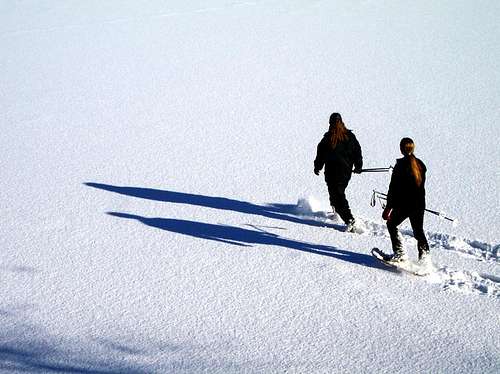
Mountains in Washington State, U.S.A. are usually thought of as the rugged, glaciated peaks of the Cascade Mountains. The Kettle River Range is an older and very different sort of mountainous range. Rounded summits interspersed with rolling larch, fir and pine forests, accented by ridge top meadows. This is the land of black bears, cougars, lynx, moose, mule deer, bald eagles, and horned owls. The occasional elk roam the upper meadows where the call of wild turkeys can often be heard. The weather of the Kettle River Range is generally better than the Cascades and the trails more easily hike-able.
Activity Type: Hiking
Nearby City: Republic
Length: 30 total miles
Elevation Gain: 5,000 feet
Trail Type: Point-to-point
Skill Level: Moderate
Duration: 3 days Season:
Usually open June to late October; best mid-June to mid-July / mid-October
Trailhead Elevation: 5,587 feet
Other Uses: horseback riding, snowshoeing, trekking, dogs allowed
Local Contacts: Republic Ranger District
Local Maps: USGS - Copper Butte, Mount Leona, & Sherman Peak
Topo Map: Kettle Crest Trail (Backpacking) Topographic Map
Guide Book: Backpacking Washington Guide Book
Lets take a look as some of the trailheads and trails of the Kettle River Range…
The Kettle Crest South Trail:
Traversing the ridgeline of the Kettles from south of White Mountain all the way to the Boulder / Deer Creek summit the Kettle Crest Trail 13 is a national recreation trail. 42-mile in length and crossing Sherman Pass (WA State Hwy20 / the Sherman Pass Scenic Byway). This, according to some is one of Washington’s finest high-country long-distance trails. To do the entire length plan for three- or four-night trek
Activity Type: Hiking
Nearby City: Republic
Length: 13.5 total miles
Elevation Gain: 3,200 feet
Trail Type: Point-to-point
Duration: 2 days Season:
Best June through October
Trailhead Elevation: 5,200 feet
Top Elevation: 6,923 feet
Other Uses: horseback riding, snowshoeing, trekking, dogs allowed
Local Contacts: Colville National Forest, Three Rivers Ranger District
Local Maps: USGS Sherman Peak
Topo Map: Kettle Crest South Trail Topographic Map
Guide Books: Inland Northwest Guide Book
Kettle Crest North
This is a 30 mile loop trip around Columbia Mountain easily accessed from Sherman Pass and the scenic byway. Look for the abandoned fire lookout cabin on Columbia Mountain.
Activity Type: Hiking
Nearby City: Republic
Length: 8 total miles
Elevation Gain: Minimal
Trail Type: Loop Skill Level: Moderate
Duration: 4 hours
Season: Mid-June through October
Trailhead Elevation: 5,575 feet
Top Elevation: 6,780 feet
Other Uses: horseback riding, snowshoeing, trekking, dogs allowed
Local Contacts: Colville National Forest, Republic District
Local Maps: USGS Sherman Peak
Topo Map: Columbia Mountain Loop (Kettle Crest North) Topographic
Map Guide Book: 100 Hikes in the Inland Northwest Guide Book
Sherman Peak Loop (Kettle Crest South)
The trail heads south from Sherman Pass, the highest year round maintained highway pass in Washington State, running 13 miles through the 1988 White Mountain fire snags and the dense re-growth from that fire. This National Recreation Trail ends just south of White Mountain on lands managed by WDFW (Washington State Department of Fish and Wildlife). The ‘loop’ portion of this trail is a 5.5 mile section rounding Sherman Peak. Great views of the Kettle River Range dominate this trail in all directions. The Snow Peak Cabin is also accessible from this trail system.
Activity Type: Hiking
Nearby City: Republic
Length: 5.3 total miles
Elevation Gain: Minimal
Trail Type: Loop
Skill Level: Moderate
Duration: 4 hours or overnight
Season: Mid-June through October
Trailhead Elevation: 5,575 feet
Top Elevation: 6,440 feet
Other Uses: horseback riding, snowshoeing, trekking, dogs allowed
Local Contacts: Colville National Forest, Three Rivers District, Kettle Falls Office
Local Maps: USGS Sherman Peak
Topo Map: Sherman Peak Loop (Kettle Crest South) Topographic Map
Guide Book: 100 Hikes in the Inland Northwest Guide Book
The Copper Butte Trail:
The most extensive alpine meadows of the Kettle River Range are draped across 7,123 feet (2,171.09 meters) Copper Butte. If you hike Copper Butte or it’s surrounding neighbors in the spring season the mountain side will be bright yellow with arrowleaf balsamroot, arnica, yellow violets, and mountain dandelions. Later as summer commences purple lupine offers different shading. The entire Kettle Range (and remainder of the Monoshees to the north) can be observed from the old lookout site. You’ll also note Idaho’s Selkirks to the east, Canada’s Rossland Range to the north, with the westerly view dominated by miles of alpine meadows, punctuated by the looming monadnock of Mount Bonaparte and ending with Washington’s Cascade Range as the backdrop.
Activity Type: Hiking
Nearby City: Republic
Length: 9.5 total miles
Elevation Gain: 2,390 feet
Trail Type: Out-and-back
Duration: 6 hours
Season: Best late May through October
Trailhead Elevation: 4,600 feet
Top Elevation: 7,140 feet
Other Uses: horseback riding, snowshoeing, trekking, dogs allowed
Local Contacts: Colville National Forest, Republic Ranger District
Local Maps: USGS Copper Butte
Topo Map: Copper Butte Trail Topographic
Map Guide Book: Inland Northwest Guide Book
Geology

Do you have an interest in the paleoenvironments and geological features of the areas you visit? If so there’s a good chance your going to enjoy the Stonerose Interpretive Center located in the foothills immediately west of the Kettle River Range in the town of Republic WA. Stonerose is the name of a fossil site, a place where impressions of plants, insects, and fish that lived 50 million years ago (Eocene Epoch) can be found in shale.
The mountainous area around Republic WA, just 12 miles west of the Kettle Crest Trail, was once a vast lake. Due to the volcanic activity many layers of powdery ash sediment built up on the lakebed. These layers of the old lake bottom can be seen today as layers of fine-grained tuffaceous shale, volcanic ash hardened into sedimentary rock. The layers of shale split apart like pages in a book revealing fossils and information about the ancient lake and its surrounding vegetation. Within these layers, the insects and fish that drifted to the lake bottom, and the leaves and twigs that floated downstream or blew into the lake can now be seen as fossils.
By the time the Stonerose fossils were laid down, the great age of the dinosaurs was long past. The giant reptiles had been extinct for fifteen million years. The Pacific Northwest was very different from the region we know today. The Cascade Mountains were not there to block the flow of warm, moist air from the Pacific, so the climate was warmer and wetter than today's. The ancestors of our familiar temperate-forest trees intermingled with broadleaved trees, which are now native to the southeastern states and to plants that today grow only in the Far East.
Some of the plants/animals found at Stonerose are now extinct; fossils are all that remain. The ecologically successful plants have left many descendants that are still recognizable all around the world.
Unlike many fossil sites, Stonerose is a hands-on experience. The public is welcome to visit Stonerose and search for fossils in the Eocene fossil beds. At the time of your visit, the Stonerose staff will explain the rules for digging and how to find fossils. After showing all your finds to the staff for identification, you may keep three fossils per day.
My thanks to Catherine Brown, director of Stonerose Interpretive Center
Stonerose Interpretive Center
History
Ancient Landscapes:
Approximately 500 hundred million years ago an assembly of collisions was in motion triggering an event on the western reaches of what is now North America. Deep in the ocean basin, between a chain of volcanic islands and the continent, marine hotsprings deposited the heavy metals - gold, silver, zinc and copper. The ever moving Pacific plate pressurized against North America 450 million years ago compressing rocks against and often over the shoreline. This thrust extended from what is now southeastern Nevada thru central British Columbia. Thus the birth of the Kettle River Range and many other mountainous groups within the inland Pacific Northwest.
Sanpoil Volcanism:
The collisions and subsequent compressions changed 45 to 50 million years ago creating a very dynamic time for this area. The resulting pile of lifted rock was so thickened and unstable it fell apart under its own weight. Massive sliding planes of blocks reversed direction. The entire Kettle River Range slid west and rose in a band that runs the length of what we now know as Ferry County. In the foothills of the Kettle River Range, the mountains now known as Johnny George Mountain to the south, Storm King Mountain to the west and Vulcan Mountain to the north all shouldered up during that slide forming domed blocks and creating valleys filled with debris eroded from rising mountains. Volcanic vents spewed hot basalt allowing gold and silver to deposit near the surface. Under layers of volcanic ash fossils of Dawn Redwood (metasequioa) and the world’s oldest rose family leaves were entombed in lake beds near Republic WA.
Fast Forward the Clock:
The Kettle River Range, like the Okanogan Range, and the Selkirks - are foothills of the Rocky Mountains. Over the course of the last two million years, from what is now the Canadian north, the mile-high ice sheets of the piedmount ice flow encompassed all but the tallest peaks of these mountains. Ice Age glaciers carved valleys in these predominantly north to south mountain ranges, the ice grinding off sharp edges, leaving rounded mountain summits.
What we know as the topographic landscape of the Kettle River Range emerged from the ice 10,000 years ago. The troughs between the mountains channel water into the Columbia River system. Flora and fauna followed the retreating glaciers northward, and humans were not far behind. The historical record indicates the first indigenous people began hunting, fishing, and gathering in the area about 9,000 years ago.
Populated History:
With the retreat of the glaciers a lush rich landscape emerged. Salmon followed the rivers to their headwaters spawning in each stream, creek and tributary. Mountain forests and meadows became home to moose, deer, and elk. Berries thick on the bushes attracted the black bears. The Kalispel tribal legend tells of scouts who once mistook a valley for a huge lake because it was so thick with blue camas blossoms.
On the eastern slope of the Kettle River Range is a very special location where the Kettle River and the Columbia River meet. Here was what we call Kettle Falls, Shonitkwu in the Salish tongue meaning ‘Roaring Waters’. Tribes of Native Americans met each year at Shonitkwu in the shadow of the Kettle River Range to fish and trade. Travel routes were worn into the ridge tops by centuries of yearly migration to the area. Many tribes harvested the bounty, coming from as far away the Cascades and the Rocky Mountains during salmon runs.
According to archeological studies it is estimated that Indians caught more than 1,000 salmon a day at Kettle Falls during peak runs. Kettle Falls was a low falls interspersed with rock outcroppings where the salmon congregated. While the fish labored upstream, fishermen either stood on rocks or constructed wooden platforms to spear and net the fish. Large camps of people near the falls smoked and dried the fish, a staple for winter use.
Local tribes welcomed the salmon back to the river each year with a First Salmon Ceremony. The nearby mountains of the Kettle River Range was a sacred area where young people entering adulthood pursued vision quest. Even today with the falls submerged under the impeded Columbia River, the First Salmon Ceremony is still celebrated at an intertribal event at Kettle Falls, and modern young Indians may spend time in the mountains seeking to connect with their spiritual roots.
In 1809 David Thompson, the first non native fur trapper came into eastern slopes of the Kettle River Range from Canada. Thompson’s exploration opened the door for the many trappers who followed hunting beaver, marten, and other animal pelts for European fur hats and coats. Over the course of a short few years the trade established with the local tribes introduced beads, tools, and alcohol.
Dark Times:
Within two to three decades of the trade mentioned above, up to three-quarters of the native population perished to smallpox, tuberculosis, and measles, diseases to which they had no resistance. Simultaneously missionaries came to save Indian souls, forcing native religions and language underground.
In the late 1800's the Indians were confined to reservations. Soon after American fur traders were living in Fort Colville, near the Kettle Falls combined efforts with the settlers, the military and missionaries to restrict native access to fishing at Kettle Falls.
What is now the Sherman Pass Scenic Byway was at first a historic route used by Native Americans as they made their way to fishing grounds of the Columbia River. The trail later became a pioneer wagon route and was named after Civil War General William T. Sherman, who passed through the area in the 1883.
Gold Rush / Land Rush:
“There’s gold in them there hills” and “free land” was the cry that lured further settlement to the valleys surrounding the Kettle River Range and while the miners and homesteaders were plentiful the promises of quick riches and easy living did not hold true. The peak settlement population of this area which had established by 1910 had dropped by half when the year 1920 arrived. The only gold found in quantities rich enough for commercial mining was in the area of Republic WA. Today, according to the Colville National Forest, empty mines pock the hillsides, and rotting cabins stand in abandoned fields throughout the Kettle River Range.
Colville National Forest also notes: loggers and ranchers found good supplies of trees and grass on public land. Early land use was unregulated, but when the Colville National Forest was established in 1906, rangers began overseeing private resource harvest. After a hostile beginning, a working relationship evolved between the Forest Service and those who used the national forest lands. The Kettle River Range lies primarily within the confines of the Colville National Forest.
During record dry periods between 1910 and 1920 much of the Kettle River Range forests burned in wildfires started by dry lightning storms and scorching the landscape south to north.
The Colville National Forest underwent another change with the coming of The Civilian Conservation Corps (CCCs) in the 1930s. CCC workers built roads, trails, camps, fire lookout towers and buildings, some of which are still in use today. The CCC Camp Growden, was built in the Kettle River Range on Sherman Creek west of the Columbia River.
What appears to have closed the last historical chapter to this area happened in June 1940 when the waters behind Grand Coulee Dam rose 380 feet, flooding 21,000 acres (85km2) and creating Franklin D. Roosevelt Lake with nearly 600 miles of indented shoreline. At this time Kettle Falls (Shonitkwu), the prominant and sacred waters of the local tribes was silenced under the flooding waters.
Contemporary Times:
The Kettle River Range today is a mixture of land use schemes. Recreationists value the area for it’s trails, remote beauty and as a platform for outdoor experiences from simple to advanced in scale. Hunting and fishing make up a large part of the recreational activities in this area. Conservationists have movements afoot to establish what they have classified as critical landscapes set to be aside in roadless and wilderness areas. Development of private lands on the lower slopes and in the foothills of the Kettle River Range continue unchecked causing a situation fire managers call the WUI (Wildland Urban Interface) where land conversion is occurring in the fire-prone forest areas. Timber is still harvested, gold is still mined, livestock are still grazed and the local communities depend on these resource extractions for their economies.
I’ll close this history portion of the Kettle River Range page with words from the Colville National Forest, the primary keeper of these unique and rich mountain landscapes, “The Colville National Forest has not been entirely tamed into an urban playground like some national forests closer to large cities”.