
|
|
Mountain/Rock |
|---|---|
|
|
41.20100°N / 118.555°W |
|
|
8923 ft / 2720 m |
|
|
Overview & Description
Update Oct 2004: See this newspaper article on King Lear Peak by Mark in the Reno Gazette Journal
King Lear Peak is arguably one of Nevada's Top 20 peaks, if not in the Top 10. While its altitude (just shy of 9000') is fairly tame, it stands out because of several other factors --- namely remoteness, ruggedness, appearance, and summit views. The climb itself is no slouch --- depending on the route, total gain can be as high as 5000'.
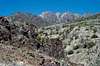
Few Great Basin peaks offer quality rock routes, but King Lear boasts an abundance of lengthy class 3 & 4 options from every point on the compass. The geology is weathered volcanics with limestone lensing. Although this does not support 5th class pro very well, it does fracture nicely for 3rd & 4th class slab climbing.
To say that King Lear is "remote" is to understate slightly. The peak is situated in the Jackson Mountains, on the northeast border of the infamous Black Rock Desert in northwestern Nevada. As you might expect, just getting to the trailhead requires extra preparation.
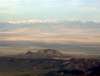
King Lear does not share the typical Basin & Range erosion profile, mainly due to the fact that the top 2000+ feet is comprised of a solid block of volcanics. This gives instead the appearance of a real "mountaineer's" peak, whether viewed from the trailhead or downtown Gerlach, Nevada, nearly 60 air miles away.
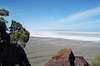
Summit views are of course spectacular, with the northern Great Basin stretching away in every direction. To the west is the 100-mile expanse of playa and dust known as the Black Rock Desert, with Mt. Lassen shimmering in the distance; to the east is range upon range of mountains, each attempting to block the winding path of the Humboldt River as it drains from high peaks near Utah; far to the south are the beginnings of the Sierra; to the north lie the great plateaus of southern Oregon and Idaho.
Many folk indeed climb this peak; possibly over 20 per year (as desert peaks go, this is a solid number). Routes vary, but chances are that few involve the north-south ridge traverses; instead the peak is primarily climbed directly from the east or west.
The summit "can" as of March 10, 2003 is a glass jar with a leaky lid. It is tucked away in a 12-inch-high cairn on the extreme north end of the summit ridge. While the register is still legible, unless the can is changed out soon it will deteriorate. If you go up, try to bring a replacement that is UV resistant. Plastic bags will not last --- schedule 40 PVC pipe might work OK.
Wildlife is abundent in the area, with pronghorn being quite prolific. Mule deer, bighorn sheep, coyotes, various wild cats, and feral horses also may be seen. King Lear Peak is home to a fairly old (1000+ yrs?) Juniper population, due to the natural fire protection offered by the rocky terrain.
 |  |  |  |  |
Getting to the Middle of Nowhere
West Trailhead (approx. 170 miles from Reno, NV)
To approach from the west, hypothetically from Reno, Interstate 80 is taken approximately 20 miles east to the Wadsworth/Pyramid Lake exit. State Highway 447 is then taken north for about 72 miles, just shy of Gerlach. About 3 miles after passing through the small dwelling of Empire, look for a pole-line road leading off the pavement to the right. If you reach the playa, you've gone too far. If you reach Gerlach, you've gone 3 miles too far; if you reach Planet X Pottery, you're just waaaay out there.
This dirt road will have BLM signs at various intersections stating distances to locations. Your initial goal is the deserted whistle-stop of Sulfur, about 41 miles east of the pavement of Hwy 447. This stretch of road is decent, but there are sections of LARGE, SHARP gravel that can rip tires open like cutting butter at high speeds. It is recommended that this stretch be driven slower than 45mph. Soon after reaching this road, King Lear can be seen away to the northeast across the desert --- it will remain in view for the rest of the journey.
Sulphur is just a couple of stone foundations and junked cars sitting at a junction of dirt roads, power lines, and railroad tracks. Here turn left (north) and cross the railroad tracks. While this section does not get maintained like the first dirt leg, it is still quite drivable with a lower-clearance vehicle --- most of this part, however, is underlain by opal-infested alluvium, meaning SHARP quartz rocks that will eat your tires for lunch at high speeds. Drive this section below 40mph and watch for small gullies in the road. Proceed down this road for 25 miles, passing at first a windmill, then a hot-spring, and finally another windmill, all on the right. Your turnoff will be to the right (east) towards the now-near base of the mountain.
Once you have turned off the primary dirt road, you are only 1 mile from the trailhead. Follow it to a spring system and the large clumps of buckbrush that stick out like a sore thumb, park the car, and go for it! This final section is negotiable in a 2-wheel-drive vehicle, but involves careful tire placement. Again, since it is only a mile of low-angle alluvium, it would not be a problem to walk it if needed.
If you are coming from the Salt Lake City direction (east) on I-80, but want to climb the west side of King Lear, follow the first part of the East Approaches directions --- don't turn off at Jungo, just stay on the Jungo Road until you get to Sulfur (20 miles more).
If you are coming from Oregon, and crossing the Nevada border at the town of Denio, travel south for approximately 30 miles on Hwy 140. There will be a dirt road to the right that should have a sign indicating the Jackson Creek Ranch and possibly Sulfur. Follow this dirt road for about 30 miles (past the ranch) and look for the Buckbrush Springs about a mile off the road on the left towards the peak. That's your trailhead!
East Approaches
Update Oct 2004: Mark from the RGJ writes:
"Murdock recommended the eastern approach from Big Cedar Creek, which starts at a higher elevation than the western approach and may be the easiest and most direct route. The eastern approach begins at the wilderness area boundary at Big Cedar Creek. From the wilderness boundary, follow the closed road to the eastern facing rib protruding from the main north-south ridge. Follow the rib to the base of the highest drainage below the two points of King Lear Peak. The left point is the summit proper. Follow the drainage to the saddle between the two points. From the saddle, the easiest route to the summit follows a notch that begins on the northwest face of the summit block. Bighorn sheep travel on this notch and have created something of a trail that leads to a short and easy Class 4 scramble to the summit." See this newspaper article for more information.
As of this writing, I have not attempted this peak from the east, and so these directions will be more general. The type of vehicle required is unknown for the last 20 miles, but most likely 2wd until the final 3-4 miles, as there are a few active ranches out that way.
From the town of Winnemucca on Interstate-80, follow the signs to Hwy 95 North. Go under the freeway, over the river, and over the railroad tracks. Take the first street left (west) that parallels the tracks --- you're looking for the Jungo Road. Stay on the Jungo Road for 35 miles --- until you get to Jungo. Turn right (north) and follow that road for 16 miles and then bear to the left. There are a number of roads (4wd?) turning off to the left that lead to the base of the peak.
 |  |  |  |
Red Tape
Parts of this area were recently appropriated as a "wilderness" area. The BLM thus has new signs out declaring motorized vehicles, bicycles, and hang-gliders to be evil in certain spots. Please leave the signs undisturbed so as to not hinder the enjoyment of others.
Climbers should take into account the fall deer-hunting seasons --- don't dress like a deer, and expect to see people if you go during these times.
 |  |
When To Climb --- Your Choice!
The comparatively mild snow conditions of the Great Basin offer an extended dayhiking season for those who don't like to gear up for major winter alpine adventures. Winter climbs should be done with waterproof boots and possibly gaiters if there is any snow.
Summer hikes should always involve lots of water, as the evaporation rates get quite high in the desert. If doing a rock route late-spring to early-fall should ensure dry conditions.
There are a few water sources on this peak, including a spring at the west trailhead --- however, the "wild" horses, cows, and antelope have the run of the springs, so make sure you treat it thoroughly (i.e. boil, etc)! I say bring your own....
Times of high snow accumulation and/or muddy conditions will hamper driving efforts on the dirt road sections. Have high-clearance and 4WD (and know how to use it) if you go during a potentially stormy day.
Camping & Lodging
Camping is available literally all over the place. There are no fees for camping on BLM or general USFS land. Stay off the private, and you should be fine!
Lodging is available in Reno (170 miles), Winnemucca (70 miles), and Gerlach (70 miles).
Mountain Conditions...Can Change Rapidly
Like most isolated Great Basin peaks, this one requires creative research and
a lot of guessing to determine current conditions!
Although I haven't cleared it, if you REALLY need to know, call Bruno's Cafe & Bar in Gerlach (775.557.2220) and ask them to stick their head out the door and tell you what they can see from 60 miles away....
 |