
|
|
Canyon |
|---|---|
|
|
36.79100°N / 118.669°W |
|
|
Hiking, Mountaineering, Trad Climbing, Sport Climbing, Toprope, Bouldering, Ice Climbing, Aid Climbing, Big Wall, Mixed, Scrambling, Via Ferrata, Canyoneering, Skiing |
|
|
Spring, Summer, Fall, Winter |
|
|
Overview
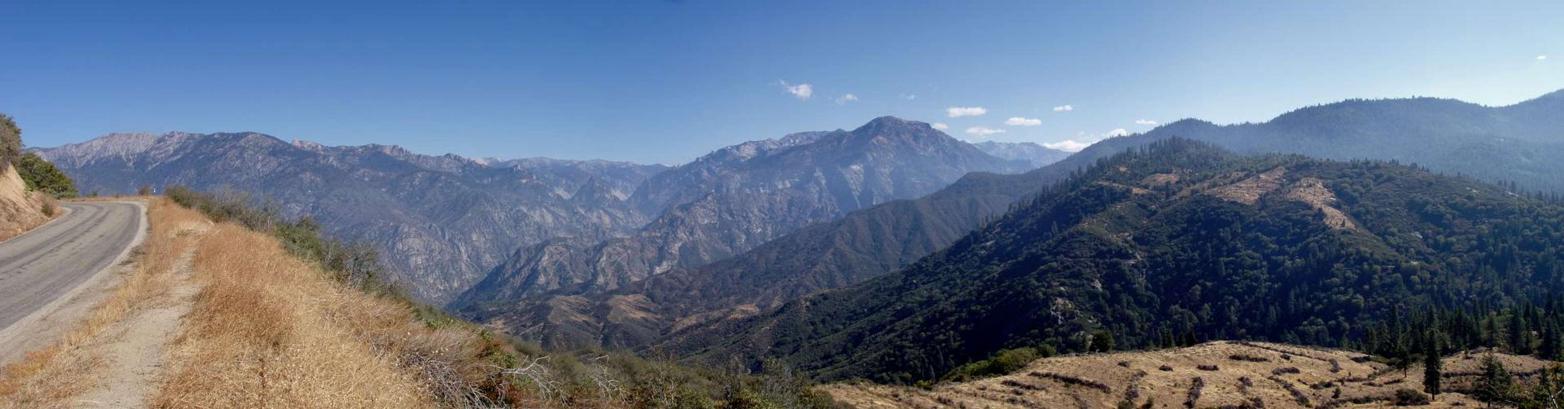
The canyons of the Kings River are magnificent deep gorges featuring spectacular tall cliffs, wild white water rivers, green vibrant meadows, marble caverns, and beautiful waterfalls. There are three forks of the Kings River - the North, Middle, and South - and they all start up near the Sierra Crest. The North Fork starts in the Sierra National Forest and the Middle and South start in Kings Canyon National Park. The confluence of the South Fork and Middle Forks of the Kings River lies at 2,260 feet in the Sequoia National Forest, while towering above the rivers on the north side of the canyon is Spanish Peak, which is 10,051 feet tall. This canyon is arguably the deepest canyon in North America for a short distance.The North Fork Kings River starts in the John Muir Wilderness of the Sierra National Forest and flows in a westerly direction. It is impounded at Wishon Reservoir and then flows in a southerly direction through Blackrock Reservoir and eventually meets the other two forks just east of Pine Flat Reservoir.
The Middle and South Forks are both designated as Wild and Scenic Rivers from shortly below their confluence to their headwaters. This designation took place on November 3, 1987.
The Middle Fork Kings River starts in the northern part of Kings Canyon National Park. It flows through a beautiful glacially carved canyon known as Tehipite Valley before joining the South Fork near Yucca Point in the Sequoia National Forest.
The South Fork Kings River also flows through a glacially carved canyon and this stretch is known as the Kings Canyon. I think a no more beautiful descriptive overview exists for Kings Canyon other than John Muir's so I've decided to include it here.
A Rival of the Yosemite
The Cañon of the South Fork of Kings River, California
by John Muir, 1891
"In the vast Sierra wilderness far to the southward of the famous Yosemite Valley, there is a yet grander valley of the same kind. It is situated on the south fork of King's River, above the most extensive groves and forests of the giant sequoia, and beneath the shadows the highest mountains in the range, where the cañons are deepest and the snow-laden peaks are crowded most closely together. It is called the Big King's River Cañon, or King's River Yosemite, and is reached by way of Visalia, the nearest point on the Southern Pacific Railroad, from which the distance is about forty-five miles, or by the Kearsarge Pass from the east side of the range. It is about ten miles long, half a mile wide, and the stupendous rocks of purplish gray granite that form the walls are from 2500 to 5000 feet in height, while the depth of the valley beloved the general surface of the mountain mass from which it has been carved is considerably more than a mile. Thus it appears that this new Yosemite is longer and deeper, and lies embedded in grander mountains, than the well-known Yosemite of the Merced. Their general characters, however are wonderfully alike, and they bear the same relationship to the fountains of the ancient glaciers above them.
"As to waterfalls, those of the new valley are far less striking in general views, although the volume of falling water is nearly twice as great and comes from higher sources. The descent of the King's River streams is mostly made in the form of cascades, which are outspread in flat plume-like sheets on smooth slopes, or are squeezed in narrow-throated gorges, boiling, seething, in deep swirling pools, pouring from lin to lin, and breaking into ragged, tossing masses of spray and foam in boulder-choked cañons,--making marvelous mixtures with the downpouring sunbeams, displaying a thousand and colors, and giving forth a great variety of wild mountain melody, which, rolling from side to side against the echoing cliffs, is at length all combined into one smooth, massy sea-like roar.
"The bottom of the valley is about 5000 feet above the sea, and its level or gently sloping surface is diversified with flowery meadows and groves and open sunny flats, through the midst of which the crystal river, ever changing, ever beautiful, makes it way; now gliding softly with scarce a ripple over beds of brown pebbles, now rustling and leaping in wild exultation across avalanche rock-dams or terminal moraines, swaying from side to side, beaten with sunshine, or embowered with leaning pines and firs, alders, willows, and tall balsam poplars, which with the bushes and grass at their feet make charming banks. Gnarled snags and stumps here and there reach out from the banks making cover for trout which seem to have caught their colors from rainbow spray, though hiding mostly in shadows, where the current swirls slowly and protecting sedges and willows dip their leaves.
"From this long, flowery, forested, well-watered park the walls rise abruptly in plain precipices or richly sculptured masses partly separated by side cañons baring wonderful wealth and variety of architectural forms, which are as wonderful in beauty of color and fineness of finish as in colossal height and mass The So-called war of the elements has done them no harm. There is no unsightly defacement as yet; deep in the sky, inviting the onset of storms through unnumbered centuries, they still stand firm and seemingly as fresh and unworn as new-born flowers.
"From the brink of the walls on either side the ground still rises in a series of ice-carved ridges and basins, superbly forested and adorned with many small lakes and meadows where deer and bear find grateful homes; while from the head of the valley mountains other mountains rise beyond in glorious array, every one of them shining with rock crystals and snow, and with a network of streams that sing their way down from lake to lake through a labyrinth of ice-burnished cañons. The area of the basins drained by the streams entering the valley is about 450 square miles, and the elevation of the rim of the general basin is from 9000 to upward of 14,000 feet above the sea; while the general basin of the Merced Yosemite has an area of 250 square miles, and its elevation is much lower.
"When from some commanding summit we view the mighty wilderness about this central valley, and, after tracing its tributary streams, note how every converging cañon shows in its sculpture, moraines, and shining surfaces that it was once the channel of a glacier, contemplating this dark period of grinding ice, it would seem that here was a center of storm and stress to which no life would come. But it is just where the ancient glaciers bore down on the mountain flank with crushing and destructive and most concentrated energy that the most impressive displays of divine beauty are offered to our admiration. Even now the snow falls every winter about the valley to a depth of ten to twenty feet, and the booming of avalanches is a common sound. Nevertheless the frailest flowers, blue and gold and purple, bloom on the brows of the great cañon rocks, and on the frosty peaks, up to a height of 13,000 feet, as well as in sheltered hollows and on level, meadows and lake borders and banks of streams."
To read more of this John Muir article, click here.
  |
Getting There
Hwy 180, the Kings Canyon Scenic Byway, is the main road to access the upper part of Kings Canyon. Hwy 180 leaves from Hwy 99 near Fresno and goes east climbing up through the foothills and entering the Grant Grove portion of Kings Canyon National Park at approximately 6,000 feet in elevation. From here Hwy 180 then goes through a portion of Sequoia National Forest/Giant Sequoia National Monument and here magnificent views of the canyon start to unfold. The highway then descends and begins to follow the sinuous curves of the mighty river. Here the highway is literally carved into the rock above the river and the scenery is mind-boggling. Soon you pass Boyden Cave and then cross the river. Just past Grizzly Falls you enter into Kings Canyon National Park again and here the V-shaped river canyon opens up into a wide glacial U-shape. This area is known as Cedar Grove and there are many campgrounds and trailheads as well as a small lodge, store, and visitor center. The highway is a dead end and it ends at appropriately named Road's End.Highway 180 is open to Grant Grove year-round, but is closed near Yucca Point in the wintertime (mid-November through late May, weather depending).
The lowest part of the Kings River Canyon can be accessed from County Road M-2 which skirts around the north shore of Pine Flat Reservoir east of Fresno and continues up the canyon for a short distance. This road is open year-round.
The area near Wishon Reservoir can be accessed via Hwy 168 and Mountain Road 40.
Several trails including the Don Cecil Trail from the south and the Bubb's Creek trail from the east can be used to hike into Kings Canyon. Please see the hiking trails section below.
Red Tape
There is a $20 fee charged for entrance into Sequoia & Kings Canyon National Park. This fee will get you a pass good for 7-days. You can also buy a $80 America the Beautiful Federal Lands Recreation Pass good for entrance to all National Parks, National Forests, BLM, US Fish & Wildlife, and Bureau of Reclamation sites for one year from date of purchase. If you're disabled, you may want to get an Access Pass which are free and good for a lifetime. If you're 62 years of age or older, a Senior pass can be purchased for $10 and they're also good for a lifetime. Click here for more info on fees and passes.Wilderness Permits are required for overnight trips to the wilderness areas surrounding Kings Canyon. If your trip originates in Sequoia National Forest, click here. If your trip originates in Sequoia & Kings Canyon National Parks, click here. If your trip originates in the Inyo National Forest, click here. If your trip originates in the Sierra National Forest, click here.
There are food storage requirements in Sequoia and Kings Canyon National Parks for keeping your food safe from bears. Click here for more info.
Click here to find out info on fishing regulations.
Camping
These 4 campgrounds are located in Kings Canyon within the borders of Kings Canyon National Park at Cedar Grove:Canyon View
Open as needed May to October.
Elevation 4600 feet (1402m).
Amenities: Flush toilets, pay phone at the village (1/4 mile/.4 km). 1/4 mile (.4km) from market, restaurant, showers, laundry, & horseback riding. Ranger programs nearby in July & August. One metal, bear-proof food-storage box provided at each campsite: 48" long x 34" deep x 28" high.
Fee: 23 sites at $18/night and 5 sites for groups 7-15 at $35/night.
Moraine
Open as needed May to October.
Elevation 4600 feet (1402m).
Amenities: 120 sites, flush toilets, pay phone in the village (3/4 mile/1.2 km). 3/4-mile (1.2km) from market, restaurant, gift shop, showers, laundry, & horseback riding. Ranger programs in July & August. One metal, bear-proof food-storage box provided at each campsite: 48" long x 34" deep x 28" high.
Fee: $18/night.
Sentinel
Open late April to mid-November.
At 4600-foot (1402m) elevation under open stands of evergreen trees.
Amenities: 82 sites, flush toilets, pay phone in the village (1/4 mile/.4 km). Within 1/4-mile (.4km): market, restaurant, gift shop,showers, laundry, & horseback riding. Ranger programs July-early September. The road to this area closes in mid-November. One metal, bear-proof food-storage box provided at each campsite: 48" long x 34" deep x 28" high. There are several additional boxes for sites to share.
Fee: $18/night.
Sheep Creek
Open as needed May to October.
Elevation 4600 feet (1402m).
Amenities: 111 sites, flush toilets, pay phone in the village (1/2 mile/.8 km). 1/2-mile (.8km) from showers, laundry, restaurant, market, gift shop, horseback riding. Ranger programs in July & August. One metal, bear-proof food-storage box provided at each campsite: 48" long x 34" deep x 28" high. There are several additional boxes for sites to share.
Fee: $18/night.
Blackrock Campground is near Blackrock Reservoir and Lily Pad Campground is near Wishon Reservoir. Kirch Flat, Green Cabin Flat, Camp 4, Camp 4 1/2, and Mill Flat Creek Campgrounds are located in the lowest portion of Kings Canyon in the Sequoia and Sierra National Forests just to the east of Pine Flat Reservoir. Click here to find out more information on these campgrounds. There is also a Forest Service cabin that is available to rent. Click here for more info on the Camp 4 1/2 Cabin.
Hiking Trails
Selected Day Hikes
Yucca Point Trail
This trail leaves from the Yucca Point Trailhead about one mile east of Kings Canyon Lodge in Sequoia National Forest. This trail drops about 1,600' in 2 miles down to the confluence of the South and Middle Forks of the Kings River. Most people do this trail in spring or fall because it is at a lower elevation that is hot in the summer! Beware also of poison oak, ticks, and rattlesnakes. A lot of fishermen like this trail but fishing is all catch-and-release here.
Don Cecil Trail
The Don Cecil Trail climbs the relatively cool north-facing slope of the canyon. This historic trail was the major access route to Cedar Grove prior to the completion of Highway 180 in 1939.
Sheep Creek Cascade
A moderately strenuous hike up the forested Don Cecil Trail provides views of the Monarch Divide and leads to a shady glen on Sheep Creek. This two-mile round trip takes about 1 1/2 hours and gains 600' in elevation.
Lookout Peak
Beyond Sheep Creek, the climb to Lookout Peak provides an incredible panorama of the park's backcountry. This strenuous, all-day hike is 13 miles round trip and climbs some 4000' to the summit.
Hotel Creek Trail
The cool of the morning is the best time to hike this trail, which climbs up the relatively dry, south-facing side of the canyon.
Cedar Grove Overlook
The trail switchbacks up through chaparral to a forested ridge and a rocky outcrop. This strenuous hike will reward you with a gorgeous view up and down Kings Canyon. A round trip of 5 miles with a 1200' elevation gain, this hike takes 3-4 hours to complete.
Hotel Creek - Lewis Creek Loop
If you continue 1 1/4 mile past the turn-off to Cedar Grove Overlook, the Hotel Creek Trail drops down to join the Lewis Creek Trail. This area was burned in 1980, in one of the largest fires these parks have experienced in recent years. The last 2 miles, from the Lewis Creek Trailhead back to your starting point, follow a trail above the roadway. This 8-mile round trip takes an average of 5 hours and gains 1200' to the highest point.
Mist Falls
This sandy trail follows the glaciated South Fork Canyon through forest and chaparral, past an impressive show of rapids and cascades, to one of the largest waterfalls in Sequoia and Kings Canyon National Parks. The first part of this 8-mile round trip is relatively flat; during the last mile to the falls, the trail gains 600'. The average time for this trip is 4 to 5 hours.
Selected Backpacking Trips
Bubbs Creek Trail
Steep then steady grade. Access to John Muir/Pacific Crest trails (JMT/PCT). Limit 1 night per camp area on JMT from Woods Creek to Glen Pass and in some neighboring areas. No campfires above 10,000' (3048 meters). Trailhead to begin the Rae Lakes Loop going counter-clockwise. See Woods Creek below. First campsite - Sphinx Creek (4 miles/6.4 km) Limit 25 people/day.
Woods Creek Trail
Steady moderate climb. Very busy trail. Vistas, rivers and high lakes. Access to JMT/PCT. Trailhead to begin the Rae Lakes Loop going clockwise. See Bubbs Creek above. Bubbs and Woods Creeks are popular horse-party trails. First campsite - Paradise Valley (6.5 miles/10.4 km) Limit 25 people/day.
Copper Creek Trail
Hot, steep climb; leave early in the day. Forests, vistas, alpine lakes. Access to Middle Fork of Kings River. No campfires in Granite Basin or above 10,000' (3048 meters). First campsite - Lower Tent Meadow (4 miles/6.4 km) Limit 20 people/day.
Lewis Creek Trail
Hot, steep, dusty climb. Trail becomes difficult to follow north of Kennedy Pass. Forest, lakes and vistas. No campfires above 10,000' (3048 meters). First campsite - Frypan Meadow (5.5 miles/8.8 km) Limit 25 people/day.
Giant Sequoia Groves
Like big trees? There are plenty of groves in the Kings River watershed, including some that are very easily accessible like Grant Grove and some that are very hard to access like the Deer Meadow Grove.McKinley Grove
Converse Basin Grove
Indian Basin Grove
Cherry Gap Grove
Big Stump Grove
Grant Grove
Sequoia Creek Grove
Bearskin Grove
Landslide Grove
Lockwood Grove
Evans Grove
Kennedy Grove
Little Boulder Creek Grove
Boulder Creek Grove
Deer Meadow Grove
Agnew Grove
Monarch Grove
I highly recommend the book A Guide to the Sequoia Groves of California by Dwight Willard to find out more about these groves. Click here for the Sequoia Natural History Association Bookstore page that features this book.
Etymology
The Kings River was named in 1806 by Gabriel Moraga on one of the first Spanish expeditions central part of California. It was originally known as Rio de los Santos Reyes (River of the Holy Kings).External Links
Sequoia & Kings Canyon National ParksSequoia National Forest & Giant Sequoia National Monument
Sierra National Forest
Tulare County Mountains Weather Forecast
Yosemite to Kings Canyon Weather Forecast
Hume Lake WebCam
Info on Whitewater Rafting Companies who lead trips on the Kings River
More info on National Scenic and Wild Rivers in California