
-
 12310 Hits
-
 86.37% Score
-
 22 Votes
|
|
Area/Range |
|---|---|
|
|
49.79872°N / 7.44855°E |
|
|
Sport Climbing, Toprope |
|
|
Spring, Summer, Fall |
|
|
1230 ft / 375 m |
|
|
Overview
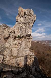
 Unnamed tower on Oberhäuser Grat Unnamed tower on Oberhäuser Grat |
Let's start with the name Kirner Dolomiten - Kirn Dolomites - suggests a rocky mountain range with much climbing potential. However, just like every beautiful landscape is called "Schweiz" (Switzerland) in Germany (just think of Sächsische Schweiz) any rocky feature seems to have earned the name "Dolomites". In this case the dreams of local climbers are to blame who would willingly exchange anything Dolomite-like for the plains and hills of their home turf. They don't even care about the rock composition: Kirner Dolomiten are made up from blocky quartzite.
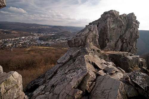
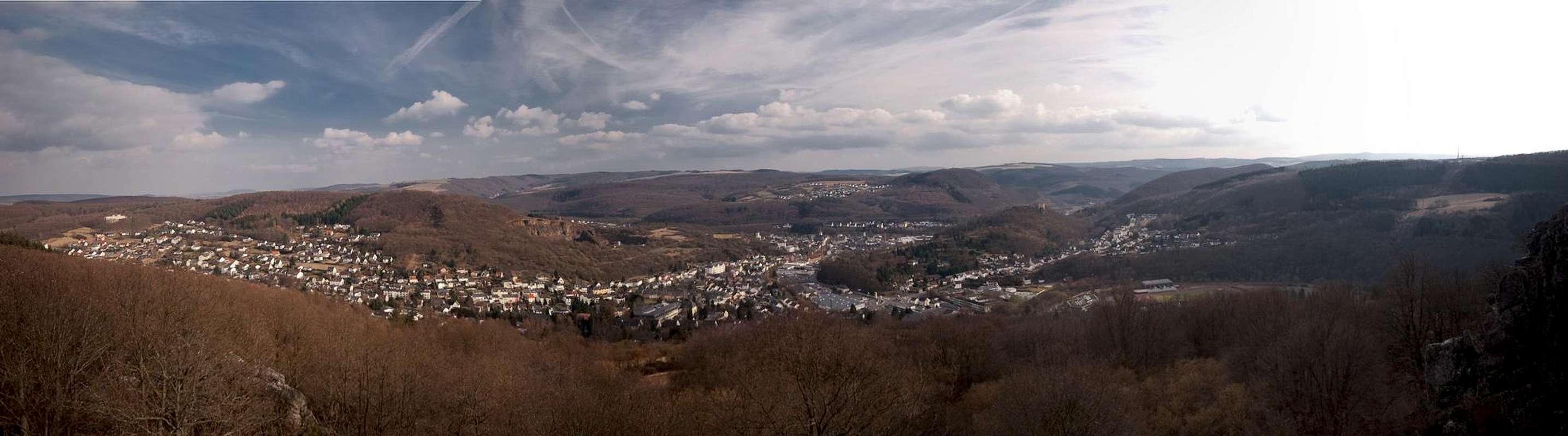
Kirn is a small town on the outskirts of Soonwald in the south-western part of the Hunsrück mountain range. It is located in a bend of the Nahe River and is famous for its brewery and the quartzite quarry pits around. To the north of the town, to both sides of the Kallenfels Valley you find an area of rocks - the Kirner Dolomiten. In the mountain ranges of Hunsrück and Taunus, which stretch on both sides of the Rhein River you can find rare - but not altogether uncommon - features made up from quartzite. They rise out of the underlying hills and mountains like sceletal ridges, so called riff-rormations. Wherever they can be found they have been either protected as natural monuments or they serve as adventure ground for the local climbers (sometimes both). Starved and hungry as the latter are, they settle even for minor riffs, where the wall "height" of 5m ensures a couple of bouldering moves take you to the tops. Nikolausfels is a good example for one of the quartzite riffs. It grows out of a steep slope and thus reaches wall heights up up to 30m.
 |  |  |  |
Among these quarzite structures Kirner Dolomiten take a special place. They are by far the largest accumulation of climbing rocks with several ridges running along in parallel. The rock quality is excellent - as is usual for this type of quartzite. Big blocks form natural staircases and on Oberhäuser Grat ledges take you to the top easily. Thus Kirner Dolomiten offer routes starting from UIAA 0 (whatever that might be) to difficult UIAA VIII. On the downside quartzite tends to become polished from wear and thus very slippery in wet conditions.
As you will see from the pictures another obstacle has to be taken into account: vegetation. Kirner Dolomiten reach heights of up to 30m (base to top) and therefore much of the climbing action takes place beneath the forest canopy. There is much moss on the north faces and the less important crags can only be reached by a severe bushwhack. Much of the bushes are thorny blackberries which virtually bar the access especially in summer.
 |  |  |  |
Kirner Dolomitesn divide into two different sections. The biggest area is close to the village of Oberhausen, high above town. There are three parallel ridges, all of which have been developed for climbing. The most popular feature is Jungfrau, a steep standalone tower which is crowned by a summit cross. Further westward, at the outskirts of the village Kallenfels you find the remains of the castle Steinkallenfels. The castle was built on top of three massive quarzite rocks but after it was blown up by French troops in the 18th century not much is left. The lowest of these three rocks, Schwarze Wand is another popular climbing crag, most likely since there is a parking lot directly at its base. Across the valley - on the western side you find the long ridge of Wehlenfels. It has only one route, a seven pitch ridge traverse. Like aforementioned Nikolausfels it rises out of the surrounding slopes and is a perfect place to get used to alpine ridge traverses.
Thanks to the many different climbing possibilities, Kirner Dolomiten are very popular among the climbing diaspora of the Rhein Main area. On fine days from spring through autumn you'll find its walls crowded. Unfortunately toproping is very popular and German climbers tend to "reserve" routes for themselves by hanging ropes from the tops. It is not uncommon that quarrels break out around this practice. Probably the best time to climb is on a fine winter day. Routes are empty and no foliage obstructs the views. On such days you can dream of the real Dolomites by spelling the inofficial names of the crags like Val-di-Roda-Crest or Mugoni Peak.
The Climbing Cliffs
There is an online climbing guide (in German), written by Thomas Hanne, which is an excellent addition to the guidebook by Christoph Deinet (see Maps and Books Section). You can find it at http://www.theo-unterwegs.de/html/kd.htm Thomas has drawn layout maps of the various sections, rather than showing the topos. The routes he climbed are available as topo photos.The following layout maps are linked. If you click them, you'll be directed to the pages on Thomas' online climbing guide . Numbers refer to the routes there. (Permission is pending)
This section is under construction until I finally decide how and what to post.
- Oberhäuser Felsen
- Oberhäuser Wand

- Oberhäuser Grat
- Northern Part

- Southern Part

- Northern Part
- Jungfrau

- Oberhäuser Wand
- Kallenfelser Wand


Getting There
 On Oberhäuser Grat
Kirn is located very close to the airport Frankfurt / Hahn, which is served by low budget airlines. A narrow and winding backroad, L182 connects to it directly.
More likely the potential aspirant will start somewhere near Frankfurt. He'll reach Kirn by the following itinerary:
- From Frankfurt take motorway A3 west in direction of Köln / Wiesbaden
- At intersection Mönchhofdreieck switch to motorway A67 south, direction Darmstadt / Mainz
- At intersection Rüsselsheimer Dreieck switch to motorway A60 west, direction Mainz / Bingen
- As you cross the Rhine River wave across the quarry pit on the left hand side. I'll wave back if I see you.
- After crossing three more motorway intersections A60 will take you to Bingen
- At intersection Dreieck Nahetal switch to A61 south, direction Alzey / Ludwigshafen
- At the next exit lleve for B41 direction Bad Kreuznach / Kirn / Idar-Oberstein
- Just before you reach Kirn leave the highway for the town centre
- Switch to L182 which will take you to Kallenfels (Schwarze Wand and Wehlenfels)
- For Oberhäuser Felsen leave L182 after 200m already. Signs lead to the village Oberhausen
- In Oberhausen turn left for the sports ground. There turn right and follow a paved forest road until you reach a small partking lot.
Red Tape
 Jungfrau Tower seen through the winter tres
Basically there is no red tape here. However, the ground on which Oberhäuser Felsen lie is privately owned. Camping or campfires are not allowed. Also, take your trash back home with you.
Glas has become a major problem in the last few years. At the bases of some of the rocks big quantities of broken bottles have been found. Take care for yourself and your ropes! And don't follow the bad example!"
Accommodation
  |
Camping
There is a campground to the south-west of Kirn. Owner is Egon Andre, Tel.: +49 6752 2267
Hotels
Google Search
Weather Conditions
Maps & Books
Maps
Digital Maps
You can get the official 50k and 25k maps as software CDs, to be found on the web page of Landesvermessungsamt Rheinland Pfalz.
- CD-ROM 1:50 000 Rheinland- Pfalz/Saarland 4.0
1:50000
ISBN: 3-89637-336-6
- CD-ROM 1:25 000 Nr. 3 Mittelrhein Taunus Rheinhessen
1:25000
ISBN: 3-89637-346-3
Regular Maps
Also by Landesvermessungsamt Rheinland Pfalz you can get topographic maps of all scales:
Books
- Kletterführer Rhein Main Gebiet
Ch. Deinet
Panico Alpinverlag, 2002
ISBN: 3-926807-76-8
Online Climbing Guide
There is a wonderful online climbing guide, which is an excellent addition to the guidebook above: