
-
 4241 Hits
-
 79.04% Score
-
 10 Votes
|
|
Mountain/Rock |
|---|---|
|
|
49.79872°N / 7.44855°E |
|
|
Trad Climbing, Sport Climbing, Toprope |
|
|
Spring, Summer, Fall |
|
|
1230 ft / 375 m |
|
|
Overview
 Oberhäuser Grat West Ridge Oberhäuser Grat West Ridge |
Oberhäuser Grat is the main climbing riff among the Kirner Dolomiten, a quartzite climbing area in the west of Germany's Hunsrück mountain range. The cliff is located close to the village of Oberhausen (-> name) on the eastern end of a small plateau. It consists of a single ridge of quartzite blocks, which seem to have been placed there for the sole purpose of climbing them. The rock is of wonderful quality: very hard with a rough surface, ideal to hold onto. The quartzite forms blocks, so that many ledges of all sizes run across the faces of the cliff.
Oberhäuser Grat is the largest cliff among the Oberhäuser Felsen rocks, running from north to south. It usually is divided in a northern and a southern part, the separation point being a saddle to the north of the highpoint of the ridge. The northen part is lower and offers routes only on the valley-side, i.e. to the east. The west face is very small and can be scrambled up to by any hiker. The top of the northern section is wide, inviting climbers and hikers alike to use it as a resting and lookout platform.
 |  |  |  |
The southern part of the ridge is about twice as high. Here most routes are on the west faces. They separate into several broad, but steeply sloped ledges, which offer easy access to the top of the cliff. A single east-west running ridge runs from the highest spot towards the west, ending in a nice leaning tower.
 |  | 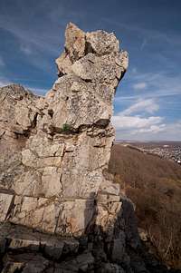 |  |
The ridge ends in a saddle, which separates it from the standalone tower of Jungfrau, which in return is separated by another saddle from a continuation of the ridge. Here you will find easy routes up to UIAA II, wonderful for motivated hikers. The ridge runs out to the south and vanishes beneath the oak and beech trees of a little forest, before dropping towards the village of Kallenfels.
 |  |  |  |
Oberhäuser Grat is the most popular climbing cliff of Kirner Dolomiten. On fine days you'll have to account for much traffic on the east face routes. Like with all German climbing cliffs, vegetation is the most serious obstacle as moss often covers the north and east faces, while bushes and brambles grow out of any nook and crevice. In late summer bases of the east face are often covered with blackberry bushes, which makes the approach to the cliffs a painful affair.
In former times the ridge was named Val di Roda Kamm, alluding to the Val di Roda Ridge in the Pale di San Martino.
Climbing routes on Oberhäuser Grat
|
| |
|
|


Getting There
 The Oberhäuser Grat summit ridge above the town of Kirn
Kirn is located very close to the airport Frankfurt / Hahn, which is served by low budget airlines. A narrow and winding backroad, L182 connects to it directly.
More likely the potential aspirant will start somewhere near Frankfurt. He'll reach Kirn by the following itinerary:
- From Frankfurt take motorway A3 west in direction of Köln / Wiesbaden
- At intersection Mönchhofdreieck switch to motorway A67 south, direction Darmstadt / Mainz
- At intersection Rüsselsheimer Dreieck switch to motorway A60 west, direction Mainz / Bingen
- As you cross the Rhine River wave across the quarry pit on the left hand side. I'll wave back if I see you.
- After crossing three more motorway intersections A60 will take you to Bingen
- At intersection Dreieck Nahetal switch to A61 south, direction Alzey / Ludwigshafen
- At the next exit leave for B41 direction Bad Kreuznach / Kirn / Idar-Oberstein
- Just before you reach Kirn leave the highway for the town centre
- Switch to L182 which will take you to Kallenfels (Schwarze Wand and Wehlenfels)
- For Oberhäuser Felsen leave L182 after 200m already. Signs lead to the village Oberhausen
- In Oberhausen turn left for the sports ground. There turn right and follow a paved forest road until you reach a small partking lot.
Red Tape
Basically there is no red tape here. However, the ground on which Oberhäuser Felsen lie is privately owned. Camping or campfires are not allowed. Also, take your trash back home with you.Glas has become a major problem in the last few years. At the bases of some of the rocks big quantities of broken bottles have been found. Take care for yourself and your ropes! And don't follow the bad example!"
Accommodation
CampingThere is a campground to the south-west of Kirn. Owner is Egon Andre, Tel.: +49 6752 2267
Hotels
Google Search
Weather Conditions
Maps & Books
Maps
Digital Maps
You can get the official 50k and 25k maps as software CDs, to be found on the web page of Landesvermessungsamt Rheinland Pfalz.
- CD-ROM 1:50 000 Rheinland- Pfalz/Saarland 4.0
1:50000
ISBN: 3-89637-336-6
- CD-ROM 1:25 000 Nr. 3 Mittelrhein Taunus Rheinhessen
1:25000
ISBN: 3-89637-346-3
Regular Maps
Also by Landesvermessungsamt Rheinland Pfalz you can get topographic maps of all scales:
Books
- Kletterführer Rhein Main Gebiet
Ch. Deinet
Panico Alpinverlag, 2002
ISBN: 3-926807-76-8
Online Climbing Guide
There is a wonderful online climbing guide, which is an excellent addition to the guidebook above: