Preparations and Start
The massif of Korab mountain is wonderful, but unfortunately for us mountaineers, it is still insufficiently explored part of the Macedonian mountains. With its cliffs, sharp peaks, deep valleys, many rivers and lakes, it is an island of untouched beauty.
The story begins more or less on standard way. The idea for the tour revolves around the head a certain period, a plan, the path traced, looking for the proper team mates. This time with us (Marin and Trajce) came Gerasimov Peter (Pero), all three members of mount.club 'Makpetrol', and Andreja Jakimovski member of the mount.club 'Makedon'. Early morning on Sunday - October, 10 2010 start from Skopje with vehicle of Mr. Pero. We reached Zirovnica village something around 6 am. Andrea, who has previously been in this area, told us that it is better to park in the upper part of the village. We found a parking spot near the top mosque. The village is clean, with many new houses and narrow streets. People are polite, ready to chat.
From Zirovnica village to sheepfold
Depart at 6:35 to the exit of the village. On the way we encounter the villagers who get up early to complete their work. One of them told us the way to Babin Kamen, it is better to take the right side of the valley of the river Zhirovnichka - which corresponded with our plan. He also told us that sheep herds slumped down from sheepfolds - which was a good information for us - did not have to worry about contact with dogs in the mountains.
The trail goes over the village and then catches the valley of the river, between the Kurtovo Kule on left and Krebuljic and Asan Kula peaks on the right side. The temperature was slightly above zero, and the grass and fern were covered with morning frost. But the sun began to appear and soon its rays began to heat up, and especially hot color of the woods lit by sunshine - golden yellow autumn color.
After about half an hour of walking, trail enters the woods. Beautiful beech forest, the path traced ideally, everyone to be able to move effortlessly. We passed two small springs along the way.
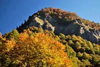
Then through the forest begin to loom the rocky beauty of the steep slope of Kurtovo Kule. Steep rocky forms, and among them beautiful grassy slopes, some tree... A true feast for the eyes.
River valley is more spread now and we are on the edge of the valley, in an amphitheater with a sheepfold. On the left side peaks Kurtovo Kule (2082 m), Javorsko Brdo (2155 m) and finally - on the border with Albania - Visoko Brdo (2245 m). On the right side is the Plocha peak (2233 m) - topped with a trapezoid shape - and on the north and west side (the Albanian side) - very steep and rocky sections.
![Visoko Brdo peak]()
My plan 'at home' was to go to Babin Kamen - a rocky and very nice hill, and then to climb to the ridge - the border with Albania, and after the crest to go back - Plocha, Visoko Brdo, Javorsko Brdo Kurtovo Kule and get down to Zirovnica village. But Andreja - who was once to Skrzhec area - the plateau over the Babin Kamen peak wanted, if possible, to go slightly to the north - to the beautiful peak Shupla Stena (2440 m). (Shupla Stena = Hollow Rock). We agreed to go first to Babin Kamen, hence considered the possibility of ascent to Supla Stena, because I knew that on that area is pretty rocky terrain.
From sheepfold to Babin Kamen peak
After the sheepfold we turn right, toward the north and climb up the Tri Sinori hill - beautiful dome which stands a little below the main peaks. When we reached its eastern side, our eyes were cached by a rock proudly protruding over the grass meadow. We had to stop under it and make a small pleasure for us climbing on it.
From this position a wonderful view opens towards the most beautiful part of the massif of Korab Mountain in the direction of Ribnichka Skala, Kabash, Guri Kuj peaks... The vast expanse now painted in warm autumn colors. Under them a wide rocky body of Babin Kamen (Grandma's Stone). Very nice hill that can offer some alpine climbing, and in winter can be a great place to camp and train steep snow and ice ascents. Especially because it is very close to the village where Thanoushe which can be reached by 4WD vehicle. At the foothill of Babin Kamen there are meadows, springs - ideal for winter and summer tours.
![Babin Kamen]()
But Babin Kamen had still to be reached. There is almost an hour walking from Tri Sinori to the foot of Babin Kamen. And there are two - three small mountain lakes, which obviously in summer were larger, and now were covered with icy surface. From here at height of 1820 meters - begins ascent to Babin Kamen. Pretty steep climb - but it will be appropriately rewarded with a beautiful view to all sides - protruding rocks below you, the tops of Korab massif, surrounding lakes and springs.
At 10:30 we are on top. Here we make a short break to have breakfast and to take some photos. Then we looked toward Suplja Stena and determined which route would be best to climb. We decided to try to climb Supla Stena until 1 p.m. - there was enough time, and meteorological conditions were excellent.
Ascent to Supla Stena
We pass the area with several springs rich in water - that part indicated on the maps as Dolni Chardak. After the springs, terrain starts to climb more steeply - first by grass, then by boulder, and at times it was easier to climb the steep slope with high grass. At height of approximately 2100 meters, there is one rockiest part, but with grass crossings between them. I chose one that seemed best for passage.
When I reached there, I saw that there is small trail - a trail that traversed from left to right. That confirmed to me this whole section - the whole range of Korab is crisscrossed from a very nice and logical trails - which were formed for centuries from locals, especially shepherds.
Then we entered onto a grass plateau which soon climbs steeply. We head to the ridge which is the border with Albania, because we want to see what is on the other side, and hence the path looked somehow more logical.
That was steep grassy slope, changing to rocks as we reached the topmost part. Especially the Albanian side has very steep cliffs, but beyond cliffs on Albanian side was spread in a beautiful valley - with alpine amphitheater and terrain which testify of former glacial influence.
Let's hope that time will come when we will be able to walk on those beautiful landscapes without red tapes and permissions.
The last part of ascent is very steep and rocky, so - in winter or bad weather conditions - one has to be extremely careful.
After the Shupla Stena peak if you want to continue to north - soon will encounter a rock wall - about fifty meters vertical which is supposed to be climbed with climbing equipment, but it is not very advisable because rock is very loose. For those who want to traverse toward Korab main peaks on the north - there is a pass from below - the trail which we found at about 2100 - 2150 meters - it goes under the Crn Kamen (Black Stone) peak in the direction of Derza peak.
We were at Supla Stena peak 15 minutes before 1 o'clock. After a brief rest we prepare to go down. At the Albanian side some clouds started to rise up.
Back to Zirovnica village
On the way back we found a natural phenomenon - a hole - a bridge over which the peak is called Shupla Stena. When we were climbing the peak we passed on the top part of the ‘bridge’, so we could not see that we are actually passing over a hole. Pero and Andreja, which passed lower during the climb, told us about this strange 'bridge'.
We descend the same path to the rock of 2150 m, and then follow the trail that slowly descends to the south - to the saddle towards the Plocha peak. The trail passes under big boulder and high cliffs on the south side of Shupla Stena.
The route than passes over the part called Gorni Chardak and continues to go down to the Trite Sinori. Here we made a break - at the point when we must pass from the other side of the mountain and when we will not be able see these beautiful landscapes - especially our favorite peak Kabash. We sat a little bit and enjoyed the vast mountainous landscape of the Korab massif.
We return back the same route we came this morning: the sheepfold, the steep sides of Kurtovo Kule, Zhirovnichka river valley, grove. We reach the village in the evening. At 6:15 p.m. we are in our car.
Technical data: Length of track: 25 km, total ascent: 1775 m


Comments
Post a Comment