

-
 26133 Hits
-
 89.96% Score
-
 31 Votes
|
|
Mountain/Rock |
|---|---|
|
|
64.06845°N / 16.92539°W |
|
|
Hiking, Mountaineering |
|
|
Summer |
|
|
3694 ft / 1126 m |
|
|
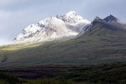
Kristínartindar from the south.
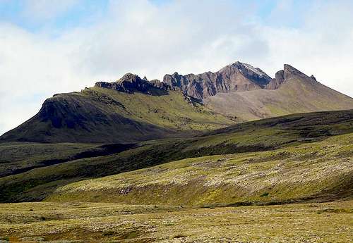
Kristínartindar from the southeast.
Overview
Kristínartindar is one of Skaftafell’s most popular mountains, often climbed because of its marvelous view and its location near the Park Visitor Center and campground. It has the added advantage of not requiring any glacier crossings and being a relatively easy climb (Class 2 in dry conditions). It is located between the glaciers Skaftafellsjökull and Morsárjökull with excellent view of each and on a good day views on to the ice cap, Vatnajökull along with surrounding mountains including Iceland's highest peak, Hvannadalshnúkur.Views
 NW from summit NW from summit |  N from summit N from summit |  NE from summit NE from summit |  NE from saddle NE from saddle |
 S from near summit S from near summit | 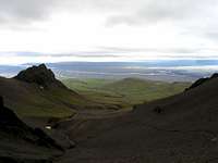 S from near saddle S from near saddle |  SE from trail SE from trail | 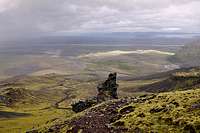 SW from trail SW from trail |
Getting There

S from Route 1
The Skaftafell Visitor Center and camping area is just off Highway 1 (The Ring Road) about 330km west of Reykjavík. Driving time from Reykjavik is about 4-5 hours depending on conditions, what you are driving, and stops along the way. The maximum speed limit in Iceland is 90 Km/hr on paved roads and wind is a definite issue if you are in high profile vehicle. The nearest town to the west is Kirkjubaejarklausir, about 67 Km. The nearest town to the east is Hofn, about 126 Km.
The Park can also be reached by bus.
The mountain is accessed from the camping area west of the Visitor Center via one of several trail combinations. Round trip is a little over 16 Km (10 miles).
See the route page for the options.
When to Climb

S Ridge 31 Aug 2013
July and August are the best periods to climb, but even then, expect the possibility of low temperatures, strong winds, precipitation of most any kind.
The following "worst case" conditions are from the main Skftafell page:
Summer travel in the highlands:
-2 ºC (28 ºF), 20 m/s (45 mph) winds, sleet or snow
Summer travel in the high mountains and glaciers:
-10 ºC (14 ºF), 25 m/s (56 mph) winds, snow
Red Tape
There are no fees or permits required as of 2013. If you are just there for the day, parking is free at the Visitor CenterHowever, be sure to check at the Visitor Center for current trail conditions and possible closures. The trails accessing Kristínartinda were closed for a short period in the summer of 2013 because of excessivly soft and muddy conditions.
Camping & Accommodations
There is a large camping area operated by the Park just west of the Visitor Center.Other accommodations in the area as well as links to accommodations elsewhere in Iceland can be found here: Tips for accommodation
Maps

Fairly detailed map

Schematic map
Two maps that you may find of use. The green cast map has better detail, the brown more trails. If enlarged, both are big enough to print and use.
Maps can also be purchased at the Visitor Center.
External Links
Main Park Homepage - Follow links to various informationPark description of the route to the peak
Third party description of Kristinartindar
Nanuls - Jun 26, 2007 8:23 am - Voted 10/10
CampsiteI would recommend not staying at the official campsite at the Skaftafell Visitors Centre. The site has increadibly poor drainage and when it rains, which it does a lot in Iceland, it tends to get very waterlogged. There is another campsite a little further east along the main road which is on a slight slope meaning it doesn't suffer from this problem. This campsite also has a swimming pool and hot-tubs, which are great after a day in the mountains.
Step - May 25, 2021 1:46 am - Hasn't voted
Paid ParkingParking is •not• free at Skaftafell (but included in the campsite fee if you stay there). Otherwise, remember to buy a day ticket at the vending machines found in the parking area.