The Drive In
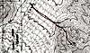
The drive on the dirt road from HWY 95 was in really great shape. When you turn off of HWY 95 to go west at the same spot where you turn for Corn Creek, you have to go against traffic for about 50 feet or so, so just make sure no one is coming down HWY 95 the other way.
Drive on the dirt road for 1.9 miles and take the left fork. After this continue driving down for a total of 6.4 miles and look for a place to park on the right side of the dirt road right next to a power pull. This is where you park.
The road is in really great condition. A passenger car could have made it no problem.
The Hike
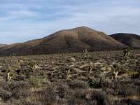
This was a nice easy desert peak. It’s a straight hike across the desert floor for about 0.65 miles. Then you have a choice of a few ridges in front of you on the North/NE side of Kyle Peak. There are some easy class 3 sections on the way. The entire 830 feet of elevation gain starts right here. It’s about 0.7 miles up to the summit.
Jim and I saw some deer on the drive in. We did not, however, see any wildlife on the way to the summit. There are many Joshua Trees blooming in the area though.
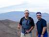
The summit
We looked and could not find a "Kyle" bench mark. There were some USGS markers though. There was no summit register. I placed one up there. I'm anxious to see the traffic that signs it in future trips there.
The views were very rewarding.
Mummy Mountain rose up to the west over Angel Peak.
Harris Mountain could be seen with some snow on top. The entire La Madre Range and
La Madre Mountain to the south was nice. My favorite views though were of the
Sheep Range to the East. This has to be one of the best places to view the Sheep Range and
Sheep Peak.
Just as the sun was setting and after taking many photos and enjoying the scenery it was time to start hiking back. Once we returned to Vegas we enjoyed some Chinese at the corner of Durango and HWY 95.
Comments
No comments posted yet.