-
 8602 Hits
-
 89.77% Score
-
 30 Votes
|
|
Route |
|---|---|
|
|
16.19432°S / 71.53207°W |
|
|
Mountaineering |
|
|
Summer |
|
|
Most of a day |
|
|
Alpine F |
|
|
Overview
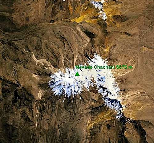
La Azufrera or North-East Route - Nevado Chachani 6075 m
La Azufrera, or Ruta Noreste, is the Normal route to get the summit of Nevado Chachani 6075 m, a mighty stratified volcano including four summits, amongst which the main one overcomes six thousand meters: the North-West summit or main summit 6075 m, the North summit or “Pico de los Angeles” 5852 m, the South-East summit or Monte Trigo 5820 m and the West summit or “La Horqueta” 5484 m., the lowest. Chachani is situated North to Arequipa, a large town in Southern Perù, the second one in the country, from where the mountain is perfectly visible.

“La Azufrera” is the easiest way to climb Chachani and one of the easiest routes allowing to climb a peak overcoming 6000 meters of altitude. As a result of the poor precipitations on Cordillera Volcanica, notwithstanding the altitude, this peak doesn’t show a wide permanent ice cap. In latest years the snow’s amount has exceptionally decreased and it decreases more during the dry season, the local winter (from June to September).


For this reason in the beginning of that season, in earlyJune and July, there are more probabilities to make an interesting and nice ascent, with more chance to find snowy and icy ground instead than powder, like during the local Spring (from October to December). In that case the ground involves the use of basical ice gear (crampons and an ice-axe).
Getting There
From Arequipa m. 2400 head to North and follow the road directed to the “Canyon del Colca”, entering between El Misti and Chachani and leading to the “Pampa de Matacaballo” at 4200 m., 45 km. from Arequipa (2 hours), quite a desert land, with the exception of rare huge moss cushion, an autochthonous species named “yareta”. Here you must turning off to left from the main road; arranging a four-wheel-drive vehicle it’s possible to follow a track reaching a drop off point at 5100 m., when the Base Camp can be put down.


Being Nevado Chachani surrounded by roads making a circuit, there’s another possible way to reach the Chachani Base Camp always starting from Arequipa: by driving towards West along a good highway and leaving the main road in Pampas Cañahuas, then following on the right a road to the “Pampa de Matacaballo”.
")
The higher camp - called Azufrera Camp or Camp I – where is suitable to sleep before rising to the summit – is situated at about 5300 m.
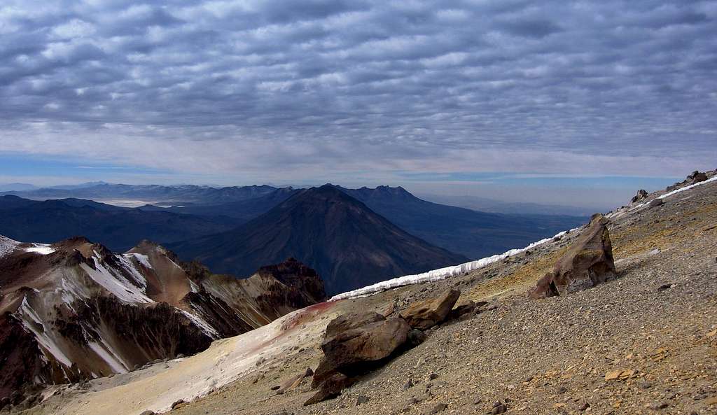
Volcan Misti seen from Chachani
Route Description
La Azufrera or North-East Route report
Summit altitude: m. 6075
Difficulty: F
Climbing length: 800 m
Exposure: NE
Starting point: Azufrera Camp or Camp I m. 5300


The climb is technically really easy, but the ascent is strenuous; as a matter of fact two crossing on relatively steep terrain constitute the main difficulties to climb the summit. Yet it shouldn’t be underestimated, indeed sometimes a true difficult is represented by the altitude and altitude sickness (AMS), especially if the mountaineer wants to climb the peak too quickly.


From the Base Camp it is advisable to rise to the Azufrera Camp and stay overnight here to get a better acclimatization. After the start from Azufrera Camp, the route is rising in about 1 hour to the Angel Col 5550 m, a cold saddle situated between Los Angeles (on the right) and Monte Trigo (on the left) summits, from where it appears an incredible view of the town of Arequipa.


After the saddle normally we begin to find the first snow or ice fields: crossing them and then soon traversing on the right side the base of Los Angeles Mountain, along steep snow’s slopes, frequently iced in early morning, we head towards Fatima, a minor summit on the way to Nevado Chachani main summit. After the climb of Fatima steep slopes along a zig zag trail, we reach the start of another crossing, a very characteristic passage of the ascent, especially in reason of the presence of "penitentes": Mount Fatima traverse.

After the “penitentes” it appears for the first time the Chachani main summit. From here we gain the base of the scree slopes giving access to the summit plateau. The final climb towards the summit involves an easy but very steep and strenuous climb up this slope, which after having summited on the contrary provides a fast descent back to the first traverse. 4-5 hours from Camp I.


Descent: reversing the same itinerary
Essential Gear
Depending on the conditions (ice and snow’s presence) the standard route can requires crampons and an ice-axe; it’s highly recommended to bring those, because it’s not easy to know the mountain’s conditions in advance and climbing the two steep traverses on ice without the gear surely is not a good idea. The standard route does not require roping up, as there are no crevasses on Chachani. Complete high mountain’s equipment is necessary. Chachani is a very cold place and temperatures can dramatically fall down during the night. In recent years, the amount of snow on Chachani has decreased remarkably, so during many months it may be a poor amount of snow on the mountain. For example, in 2010, October and November, there was no snow at all, and the ascent could be made without crampons or ice axes. Climbers would need to check on the snow conditions in advance.
When to climb

Due to the dryness of the weather in Cordillera Volcanica (Arequipa Area), having very poor precipitations, concentrated between January and March, theoretically it’s possible to climb Chachani all round year....yes, it’s possible: during these months we can find more snow, but the weather may be changeable, with snowfalls and mists. I think the best months to climb Chachani are June and July (the local “invierno”, wintertime). During this season the weather is fine and steady and, moreover, there is more snow on the mountain in comparison with the following season (September and October, the local Spring), with more chances to find the beautiful and characteristic “penitentes”.
Red Tape

")
The volcano is situated inside the Salinas y Aguada Blanca National Reserve, but there are not particular restrictions in climbing.
Meteo
External Links