
|
|
Route |
|---|---|
|
|
38.57000°N / 118.7915°W |
|
|
Scramble |
|
|
Most of a day |
|
|
Class 3 (Only a short bit) |
|
|
Approach
From Southern California:
Drive to Bridgeport, then see below to proceed from there.
From Reno:
Drive to Bridgeport, then see below to proceed from there.
From Bridgeport/Highway 395:
We'll start with the difficult part: Getting to the trailhead. From Bridgeport, CA, proceed on CA 182/NV 338 for 16 miles to a signed dirt road (Sweetwater Road) on the right that goes to Hawthorne. Proceed on this good dirt road that follows the East Walker River and it will eventually leave the East Walker and head out into the Fletcher Basin. A ranch will be encountered, and the road goes right through the yard and crosses Rough Creek. Drive s l o w l y through the yard, the ranch used to have a hand (Bob)who was psychotic and actually fired his rifle at a UPS van that went through there too fast. He must have missed, the van didn't stop or come back. (This is a first-hand account). I have been advised that Bob is no longer employed there.
The next landmark is a 4-way intersection, and you are facing to the east. The north-south road is well traveled, and a right turn takes you to the Chesco Mine, a still-active mine, while a left turn takes you towards Mt. Grant. Follow this and you will pass under a high-voltage power line, one of those with the metal towers that are balanced on a single point and steadied with cables. When you pass under these lines the second time, turn right and follow the pole line service road. This road is rough and is best traveled with a high-clearance vehicle, but not necessarily a 4WD.
At the second 4-way intersection, turn right and drive up into Lapon Canyon. This section of road is pretty good for a ways, but soon deteriorates. We were last here in February, and snow stopped us low, at about 7,500'. In low or no snow conditions, a high clearance vehicle with 4WD will save about a mile of walking if you drive all the way up to the Monarch Mine. Find a parking spot off the road, and you're ready to go.
There are no locked gates to go through from this side of the peak, no warning signs, no no-trespassing signs, but keep in mind you are on militarily controlled land.
 |  |
Route Description
Proceed up Lapon Canyon to the Monarch Mine. From here, there are rudimentary roads that switchback discontinuously up the north fork of the canyon. The better option is to locate the abandoned mine worker's trail that stays on the crest of a small ridge above the mine workings. The south fork of the canyon is a poor choice, it is infested with thick brush.
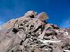
As you near the head of the canyon, bear right (east) and when you crest the ridge, the summit will be in sight, still a fair ways away. Angle northeast to gain a cat-cut that goes straight up the ridge. Soon you will decide to contour around to the west to gain the summit ridge, the most interesting part (climbing-wise) of the whole journey.
Clamber up the ridge to some amazing views. Since Mt. Grant is a stand-alone peak, the views are wonderful, and on a clear day you can see peaks 150 miles away. The panorama of the Northern Sierra is laid out before you.
 |  |  |
Essential Gear
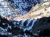
There is a stream in Lapon Canyon, probably seasonal, so if you're here in the summer, bring lots of water. Otherwise, just bring your favorite shoes.