
|
|
Route |
|---|---|
|
|
63.99400°N / 19.063°W |
|
|
Hiking |
|
|
Summer |
|
|
Class 1 & 2 with sparse Class 3 |
|
|
Overview

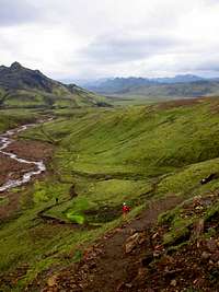
The route is an excellent hut to hut route in a remote setting. Although several of the huts are accessed by 4WD roads, much of the route traverses the slopes below Icelandic glaciers before descending into the relative verdure of Þórsmörk.
Getting There
 Approaching the Grashagakvísl
 Frostastaðavatn along road F208 heading towards Landmannalaugar.
From Selfoss on highway 1 there are two routes.
1)
- East on highway 1
- Left on route 30 past Reykir
- Right on route 32 past Sultartangi and over the Þjórsá river
- The road ends at route 26
- Left on route 26 and drive towards Hrauneyjarfoss
- Before Hrauneyjarfoss, turn right on road F208 (last gas station in area)
- Landmannalaugar is at the end of F208 (4 wheel drive may be needed)
2)
- East on highway 1 towards Hella
- Before Hella turn left on route 26 (gas station available)
* route 26 can be taken towards Hrauneyjarfoss as mentioned above, or
- Right on road F225 (4 wheel drive may be needed) which ends at road F208
- Right on road F208
- Landmannalaugar is at the end of F208
Route Description
The trail is primarily class II with a couple sections that require hands. Otherwise, snow and ice will be encountered depending on conditions. The trail is well marked with sticks marking the path. By and large the path is quite visible. There are 5 huts that can be used for comfortable camping and whose distances and elevations are listed below. The terrain surrounding much of the trail is suitable for camping as well. From the Laugavegurinn, there are many options for side trips ranging from hot springs to small mountains and glaciers. More or less this is a theme park for outdoors folks.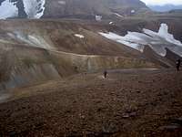 Stórihver to Höskuldsskáli
 Landmannalaugar
Major points along the route (distance from Landmannalaugar Camp)
Landmannalaugar (0 km)- Elevation: 600 meters.
Hrafntinnusker Hut (11 km) - Elevation: 1027 meters.
Álftavatn Hut(23 km) - Elevation: 600 meters.
Bláfjallakvísl River (25 km) - Elevation: 400 meters.
Emstrur Hut (39 km) - Elevation: 350 meters
Markarfljót River (50km)- Elevation: 100 meters.
Basar Huts in Þórsmörk (55km) - Elevation: 240 meters.
Essential Gear
Gear is highly dependent on the season and duration of one's trip on Laugavegurinn. For example, a winter traverse would be extremely difficult and I am not sure if it has ever been done.In general, evening temperatures on much of the trail can be expected to be at or below freezing. In the early season (late spring and early summer) treks can expect extensive snow and ice covered stretches of trail. Accoridngly, crampons and poles would be a good idea. Mid and late summer treks will encounter short stretches of ice and snow but the gear depends on one's ability to traverse such short stretches (50-100 meters) of icy and snow covered slopes.
The duration of treks can vary from more than 1 week (if many side trails and hot springs are explored) to less than 5 hours if one runs the entire trail (see external links below).
Water filters are not needed for the glacial run-off encountered along the trail.
 Leaving Álftavatn
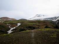 Kaldaklofsfjöll
External Links
Ferðafélag Íslands (Iceland Touring Association)Laugavagur Ultra-Marathon