
|
|
Mountain/Rock |
|---|---|
|
|
37.94621°N / 119.70738°W |
|
|
Tuolumne |
|
|
6388 ft / 1947 m |
|
|
Overview
LeConte Point is the prominent peak standing guard over the head of Hetch Hetchy Reservoir in the northwest corner of Yosemite National Park. Although not high compared the surrounding mountains, LeConte Point offers superb (and mostly snow free) winter and early spring scrambling and a splendid view. LeConte Point sees few ascents in spite of its proximity to a popular early season backpacking destination (Rancheria Falls) at its base. The summit register dates back to the early 1970s and averages about one half dozen entries per year.The climbing is fun although not too technically challenging. With a bit of route finding the east ridge can be kept to class 2. However, the rock is fairly solid and the short class 3 to 4 obstacles are very enjoyable and leave little incentive to spend much time searching for the easiest route. More sustained class 4 and 5 climbing can be found on the North and West faces but the approach to these cliffs would involve some excruciating bushwacking. The approach hike to LeConte Point is a 6.5 miles each way to Rancheria Falls following a scenic route along the north wall of Hetch Hetchy on a well built trail passing numerous waterfalls on the way. Beyond Rancheria Falls another 2 miles brings you to the summit of LeConte Point and views of the reservoir below.


Getting There
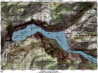 Route Map
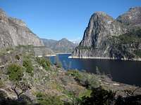 LeConte Point
The most reasonable trailhead for LeConte Point is Hetch Hetchy Reservoir, beginning at O’Shaughnessy Dam.
O’Shaughnessy Dam (37.94565° N, 119.78348° W)
From the San Joaquin Valley follow Highway 120 into Yosemite National Park and the Big Oak Flat entrance. A few hundred yards before the entrance station, turn left (east) at the sign onto Evergreen road (paved) and follow it 7.5 miles to the end. Turn right onto Hetch Hetchy Road (this point is where the gate is closed nightly) and proceed another 1.5 miles to the park entrance station. From the entrance station it is about seven more miles down to O’Shaughnessy Dam and the trailhead. The roads are open year round but can be temporarily closed after snow storms.
The most up-to-date road conditions for the park can be found by calling (209) 372-0200.
Refer to the Yosemite National Park Current Conditions page to check road status and open hours. Note that the road closes nightly and hours change seasonally.
Approach
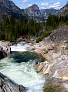
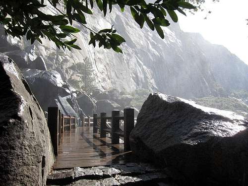 Wapama Falls Bridge
The route to LeConte Point mostly follows the popular Racheria Trail beginning at the Hetch Hetchy dam, passing several scenic waterfalls and with panoramic views of the reservoir throughout the trip.
Trip statistics for the east ridge via the Rancheria Trail:
8.5 miles one-way, 3900 feet elevation gain out plus another 1400 feet on the return
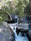
From the parking area cross O’Shaughnessy Dam and continue through the 500 foot tunnel. Hike up the old access road about a half mile to the first trial junction. Turn right on the signed Rancheria Falls trail. This trail traverses along the north wall of Hetch Hetchy passing several waterfalls including small Tueeulala Falls after 2 miles and the impressive Wapama Falls 2.5 miles from the trailhead. There is a good bit of poison oak from just before Wapama Falls until the Tiltill Creek crossing… nothing problematic but watch for the occasional branch that may encroach upon the trail.
The trail climbs and descends somewhat after Wapama Falls and then crosses the lovely gorge containing Tiltill Creek before arriving at Rancheria Creek (6.5 total miles). Continue up the trail past the likely campsites to a junction with the Tiltill Valley trail. Turn right and cross Rancheria Creek in a few hundred yards. This is the last reliable source of water in the summer or fall, although in spring there is another stream crossed a few times en route to the east ridge. The trail climbs steadily 1,200 feet to near the saddle on the east ridge of LeConte Point.
Route Description
 Hetch Hetchy Dam
Before the trail crosses the East Ridge, it comes within a short distance of the cliffs guarding the low point of the saddle (note this is just after the trail levels out at 5600 feet and before it resumes climbing again in an easterly direction). Leave the trail and scramble over several short class 2-3 rock bands and gullies to the saddle. Alternately, these cliffs can be bypassed by following the trail all the way to the ridge then down climbing to the low point through several patches of brush though this is completely unnecessary. The broad ridge is a convoluted stretch of small cliffs, sandy patches, juniper and pine trees, and some brush. Route finding is not difficult or critical.
Where the grade on the ridge starts to rise, there is a short, 50 foot class 3 to 4 cliff. This can be bypassed with minimal effort using a chute slightly to the north of the crest of the ridge. The rock is solid and the exposure is very minimal… really just a couple of very easy class 3 moves are used as you ascend. The remainder of the route is straight forward Class 1 to 2 with no major problems. The summit is a small sandy plateau with a few weathered junipers for shade. The summit register is at the high point at the west end overlooking Hetch Hetchy. Total distance since leaving the trail is about a half mile and 600 feet of climbing.
Flora and Fauna
 Lizard!
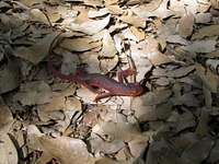 Salamander!
“Hetch Hetchy is home to a diverse array of plants and animals. Gray pine, incense-cedar, and California black oak grow in abundance. The distinctive Manzanita bush is common, and many beautiful examples of this red-barked shrub are along the road. Spring and early summer bring brightly colored wildflowers including lupine, wallflower, monkey flower, and buttercup. Seventeen species of bats inhabit this area of the park including the largest North American bat, the Western Mastiff. This large bat is only one of two bats in Yosemite whose echolocation can be heard by the human ear. Also, be alert to sightings of snakes and black bear.”– National Park Service, Hetch Hetchy Valley (2007)
Red Tape
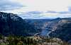
 LeConte Point Vista
Opening Hours:
The Hetch Hetchy entrance station is only open during daylight hours. The opening and closing times vary throughout the year. Currently hours are 8:00 AM to 5:00 PM in November through March, 7:00 AM to 9:00 PM May through Labor Day, and 8:00 AM to 7:00 PM during the periods in between. The gates are locked and you may be fined if you have not left before the closing time. Refer to the Yosemite National Park Current Conditions page to check open hours before your visit.
Entrance Fees:
Access to LeConte Point is through Yosemite National Park and an entrance fee is required. The Yosemite fee page has full details.
Wilderness Permits:
Permits are required for overnight trips and and subject to quotas from November through April, so if seeking a permit reservations far in advance are highly recommended. Permits are self issue 24 hours/daily at all wilderness centers outside the quota season. Check the Yosemite permit page for full details on hours, the reservation process, and reservation availability.
Food Storage:
Bear canisters are required throughout Yosemite National Park. Even so… some don’t carry them.
Campfires:
Fires are prohibited above 9,600 feet, not really a concern around Hetch Hetchy Reservoir
Yosemite National Park Wilderness Permit Office
PO Box 545
Yosemite, CA 95389
Phone: (209) 372-0740
Fax: (209) 372-0739
Current Conditions
Current NOAA / National Weather Service ForecastWhen To Climb
One of the main attractions to hiking and climbing in the Hetch Hetchy area is the year round access. The trailhead is at 3,800 feet and any winter snow usually melts within a few days. Summer climbs are very hot and not frequently done. The waterfalls are best in spring.If you day hike, watch the time! In the winter you will have to arrive when the gates open at 8:00 AM and keep a brisk pace to make the 16+ mile, 5,000+ feet round trip and be back at the entrance station by 5:00 PM.
 |
 |
 |
 |
 |
 |
Camping
 Backpackers' Campground near Hetch Hetchy
Backcountry camping is excellent at Racheria Falls although you will not find much solitude here in spring, especially on weekends. If you have an overnight wilderness permit, you can stay one night before and after your trip at the backpackers' campground near the trailhead. There is a Forest Service campground on Evergreen road that is open summer only. In the winter, the closest open campground is Hodgdon Meadow near the Big Oak Flat entrance station.
Dispersed camping is also allowed for free in Stanislaus National Forest outside the entrance stations. There are several private sections of land along Evergreen Road, so make sure you are on public land before camping.
Etymology
 Hetch Hetchy Reservoir
“Joseph Nesbit LeConte (1870-1950), a charter member of the Sierra Club, professor of engineering mechanics at the University of California at Berkeley, 1895-1937. The point was named by R. B. Marshall, USGS, in 1911. The name didn’t appear on maps until the publication of the Hetch Hetchy Reservoir 15’ quad, 1956.
John Muir described the point long before it had a name. ‘The upper end of the Yosemite Valley is closed by the great Half-Dome Rock. The upper end of Hetch-Hetchy is closed in the same way, by a rock differing from Half-Dome only in those features that are directly referable to peculiarities of physical structure. . . . In front of this head-rock, the Tuolumne River forks, just as the Merced forks in front of Half-Dome.’ (‘Hetch-Hetchy Valley.’ Overland Monthly, July 1873: 47-48.)
Joseph N. LeConte was one of the foremost explorers of the Sierra Nevada. He hiked and climbed from 1889 to 1928, wrote extensively about his travels, was an expert photographer, and compiled a number of very important maps. (See the Bibliography. Memorials in SCB 35, no. 6, June 1950: 1-8; and American Alpine Journal 7, no. 4, 1950: 484-86.)”
– Peter Browning, Yosemite Place Names (2005)
“An explanation of the meaning of the word Hetch Hetchy has been obtained through the kindness of John Muir, who says: ‘I have been informed by mountaineers who know something of the Indian language that Hetch Hetchy is the name of a species of grass that the Tuolumne Indians used for food, and which grows on the meadow at the lower end of the valley. The grain, when ripe, was gathered and beaten out and pounded into meal in mortars.’ The word was originally spelled Hatchatchie.”– Sanchez, Spanish and Indian Place Names of California (1922)