
-
 3649 Hits
-
 80.49% Score
-
 12 Votes
|
|
Route |
|---|---|
|
|
44.57959°N / 6.80861°E |
|
|
Sport Climbing |
|
|
Summer |
|
|
Most of a day |
|
|
5.10a (YDS) |
|
|
TD-, 6a (French scale) |
|
|
12 |
|
|
Overview
Les jardins d'Amandine
The mighty rocky castle of Tete de Sanglier (Wild Boar Head) shows an interesting East face overlooking the road joining St. Paul sur l’Ubaye and the small village of Maljasset. While driving in the direction of Maljasset along this road, the eye is attracted by a huge corner cutting the whole face in its central sector: a slabby wall of high quality orange and black quartzite is situated on the right-hand side of this corner. Some modern climbing routes had been realized along this face. There are some other classic routes on the South Face of the mountain.

|

|
Getting There
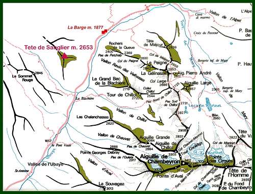
From Barcelonnette follow the road D902 rising towards NE along Ubaye Valley, reaching St. Paul sur l’Ubaye; cross the village following the road D25 to Maljasset. Park the car 500 mt. before La Barge village and 2,5 km. before Maljasset near a stream called “Beal Gros”.
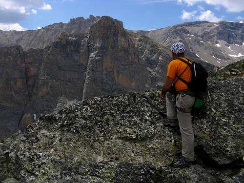
Nearby the top with Sommet Rouge NE face in front of
Les jardins d'Amandine report
Les jardins d'Amandine report
Summit altitude: m 2653
Difficulty: TD-, F6a max, F5c obbl.
Equipment: spaced bolts
Climbing length: 350 m
Exposure: E
First ascent: J.P. Chevalier – G. Fiaschi – J. Golè 1994
Starting point: nearby Béal Gros Stream along Road D25 St Paul sur l’Ubaye – Maljasset, 2500 mt before Maljasset and 500 mt before La Barge
Huts and “Gite”: Refuge CAF and Gite d’Etape “La Cure” in Maljasset.
***“Les Jardins d'Amandine” report (French Scale)
From the parking follow a little track crossing a meadow towards left, then a stream inside the forest, then rising towards the face. Last distance runs along a ledge skirting the face towards left (30 minutes from the parking). Now the usual route runs along the direct variant, situated on the left-hand side of the original route and avoiding the great black stripe often wet. The variant reachs the original route at the second belay. Starting point on the left-hand side of the black stripe. The face is crossed by a large vegetated ledge dividing it into two parts. The climbing way is the same for both cliffs, mainly along steep slabs and some little overhangs. Upper section is a bit steeper and with spaced bolts.

|

|
L1 - Climb the slab straightly, then slantways towards left, then again straightly. 5b, 40 m
L2 – Another slab. 5b+, 40 m
L3 – After a steep little wall traverse 4 m. towards left to the belay. Short pitch. 6a, then 5c, 20 m
L4 – A bit slantways towards left along a slab, then climb straightly a steep wall and finally move towards left to a belay inside a niche. 6a, then 5c, 45 m
L5 – Climb the corner on the left-hand side of the belay; after a slab, climb a little overhang and finally another slab crossed by some thin cracks, reaching a belay on the left. 5b, 6a, 40 m
L6 – Towards left entering a little corner; climb the corner, leading to a slab. Climb the slab slant to left, reaching another little corner. From here head towards right avoiding a little overhang. Belay over the median ledge. 5c, 5b. 40 m Possible going out traversing towards right along the median ledge
L7 – An easy spur, then a black slab leading to the belay near a pine. 3b, 4b

|

|
L8 – Climb some easy steps, then traverse 40 m towards left along a ledge going down to a grassy terrace. Belay near an “ometto” (stones’ pyramid) below a whitish steep pillar
L9 – Climb the steep wall with good holds, then a little overhang, reaching a slab and the belay inside a corner. 4b, then 5b, 45 m
L10 – Climb a steep wall on the left-hand side of the corner, then a slab to a little tree. Climb another steep wall, then another slab. 5c, 5a. 40 m
L11 – Climb a short slab, traverse 2 mt. left along a ledge, climb a little overhanging wall. Climb a pillar, then leave it on the right – huge block – and climb a short slabby corner leading to the belay. 5c, 5b. 35 m
L12 – Climb a pillar with broken rock reaching the belay (belay equipped). 4a, 30 m. Not equipped pitch.

|

|

|
From the belay 12 rise walking along easy slopes and rocky steps towards right, reaching a wide grassy terrace (2600 m). Here it's appearing the mighty North-East Face of Sommet Rouge! Gourgeous! Turn to right, climbing an easy ridge leading to the summit signal.
Descent - It’s possible to abseil the route, anyhow it’s heartily recommended to continue the ascent, reach the summit and descend along the Houerts Valley, doing the crossing of the mountain. The milieu is superb and the game is worth the candle!

Essential Gear
Rope 2 x 50, helmet, ten expresses, some friends and nuts, ribbons.
Red Tape
There are no particular restrictions in climbing and hiking.
Where to stay
In St. Paul sur l'Ubaye: - Equipped camping open in summer.
In Maljasset: - Refuge CAF Maljasset (French Alpine Club - CAF, mt. 1905), 60 beds, always open, phone 04 92 84 34 04 REFUGE CAF MALJASSET
- “La Cure” Gite d’etape.
In Pont d’Estreche: -Maison d’hotes “La Posada”
When to climb
Best season to climb Tete de Sanglier goes from June to October.
Meteo
External Links
GuideBooks and maps
 |
 |
- Guidebooks
"La grimpe en Ubaye" by Colin Michel CAF
“Alpes du Sud, Provence" by Hervé Galley - Editions Olizane - Geneve (Switzerland)
- Maps
IGN TOP 25 3538 ET, Aiguilles de Chambeyron