
-
 4228 Hits
-
 73.06% Score
-
 3 Votes
|
|
Route |
|---|---|
|
|
46.30568°N / 13.63047°E |
|
|
Hiking |
|
|
Summer, Fall |
|
|
Most of a day |
|
|
Medium hard walk-up |
|
|
Rating the Route (By Hiking Standards)
The grading system for hiking and scrambling routes is here. By the Swiss Hiking Scale the grading would be T3. 0. General: From Kal-Koritnica, 500 m, to 1870 m, exposition E, W. First by a broad path through woods on Golobar meadow, then by a comfortable military path till below the notch in the ridge. Finally a narrow, also a bit exposed path and pathless terrain on top. Good hiking shoes and poles. 1. Effort: cca 1400 m, 4 h. 2. Power: 1 - No difficulties, only walk-up. 3. Psyche: 2 - Easy (one exposed grassy passage). 4. Orientation: 3 - medium. |
Overview
The ascent on Lipnik from Golobar meadow is a very nice route which brings you through a wild, abandoned country on a nice, panoramic summit with a historical pedigree. On this page also the 4 variants to ascend Golobar meadow are shortly described (I did only two of them).
Getting There
See the parent page of Lipnik how to reach the 5 trailheads for Golobar ascent.
Route Description
The route from Golobar meadow is the usual and most recommended ascent on Lipnik. During the WW1 this mule track was called "Lipnik Weg". Let's first have a look how to reach Golobar meadow.
Golobar meadow ascents
1. From Kal-Koritnica

By the monument to Golobar victims the marked path deters from the main road and goes across the meadow to Soča river. Near the hanging bridge there are nice ponds (called Brjeka).
On the other side, ascend straightforwards up the hill. Be careful, because there are many tourist trails, so you must strictly follow the mountaineering path, marked with a red circle with a white dot inside. Once you hit the path, you will have no more orientation problems till Golobar. In many turns the path goes up, climbs over a steeper rocky barrier and above continues a bit towards the right. In this section we walk through a beautiful beech forrest, all the time above the deep ravine of Javoršček creek. On approximately 1000 meters you reach the building ruine, pass by it (water in the creek bed) and continue more or less in the same direction (SE) to the lower meadows of Golobar. In a few more minutes you are on the upper, bigger meadow, where in the upper part you see a big cross. There all paths join. 2 hours for some 800 meters of altitude.
2. From Predolina, 1205 m
2021 info: The path, leading from Predolina across the slopes of Kal towards Dolič and Golobar meadow is in the middle ruined by landslide and not passable!
After leaving the car on Zaprikraj meadow you walk some 15 minutes to Predolina where the unmarked but good path deters right, across the slopes of Kal summit. The path is at first comfortable, going more or less horizontally across the slopes, after passing Kal in becomes narrow on a few places, but poses no real problems. When reaching above the valley of Dolič you must descend some 100 meters to cross the valley. If you are attentive, on a nice meadow you will see the rests of the chapel from the WW1. Close to this place is also the ex alpine pasture Zadnji Slatniki (1140 m), where the marked path joins us from the left (coming from Čezsoča). Now we must ascend the slope towards Čez Utro pass, 1317 m. In a few long turns, passing the hunters hut, we reach it and a broad northern view opens. To the big cross on Golobar the marked path then descends some 50 meters.
3. From Čezsoča, 366 m
You park in the village and go eastwards into the valley of Slatenik creek. The marked path goes over the northern slopes (belonging to Javoršček). First there is a cart-road, then the marked path deters left up. There a big landslide must be crossed. In that part the path can not be well maintained so it can be tricky if wet. After the landslide, a comfortable path brings us in another 30 minutes to Zadnji Slatniki (ex pasture), where we join the variant, described above in #2. Some 2 h 30 min.
4. From Čezsoča, 366 m, directly on Golobar
Some 100 meters of Slatenik confluence into Soča, from a narrow road to Jablenica hamlet a mountain road deters right up the slopes of Javoršček. It makes some 200 meters of altitude, finally crosses the big landslide and ends. If you leave your car there, proceeding by a hunters path around the northern slopes of Javoršček, you will do the fastest ascent on Golobar. But then you must return there too. The path is comfortable and can be done in 1 h 45 min.
5. Bulfon Weg
This ex military trail is nowadays hard to follow and can so not be recommended. In addition, it is very boldly traced, so no mistakes are allowed in those steep terrains. The beginning is near the wooden bridge across Soča river, close to the confluence of Lepenjica. You can park by the camp nearby. The path goes southwards on the slope and soon branches. Bulfon Weg is the right branch. In the western and south-western direction it encircles the hill, finally reaching Golobar. 2 h, difficult orientation, path ruined on many places, terrain very steep and wild.
Summit ascent
So, there we are, on Golobar meadow. From the big cross we now continue up the hill in the SE direction.
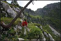
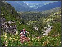
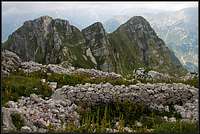
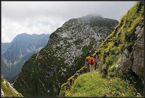
A good military mule-track goes mostly right across the forrested slopes and can be easilly tracked. After some 30 minutes it branches. The continuation in the same direction is a dead end, bringing us on frontline positions above Dolič valley. So we must go by the left branch, and there is also a ciarn indicating that (in 2009). Now the orientation problems are over. The mule track can be easilly followed. The direction is still towards the SE. The path brings us in a lighter forrest where we can spot the rests of military material cable way. In the distance, the notch in the ridge of Lipnik neighbours is well seen. Now the path is winding up by the left slopes of a distinct valley, going up to the notch. Above, on scree slopes the path is more and more narrow, but it can not be lost. We approach the notch from the left, only the last part are a few steep turns directly upwards. On the notch a magnificent view into Lepena valley and on mountains above it opens.
On the right we already see the summit of Lipnik. The path first descends some 15 meters from the notch, then it crosses comfortably the slopes of Srednja špica. The direction is towards the south. Later a few crossing passages are narrow and require some care, especially if conditions are not good (wet, slippery). But soon we reach the summit slope, where we can ascend everywhere. Actually, there we are moving through the ex military village. You will notice well preserved steps, paths connecting buildings, you easilly move from one terrace on another. A few buildings still have some walls preserved. Mostly all equipment was carried down in valleys where you can see items in private and public collections. From the notch you will need less than 30 minutes to reach the top. Altogether less than 2 hours from Golobar.