
|
|
Mountain/Rock |
|---|---|
|
|
48.39660°N / 122.3079°W |
|
|
Skagit |
|
|
Hiking |
|
|
Spring, Summer, Fall, Winter |
|
|
934 ft / 285 m |
|
|
Overview
Little Mountain is a low elevation mountain located immediately southeast of the city of Mount Vernon, Washington. Despite its small stature (with only 934' elevation), Little Mountain is one of the most visited and popular recreational destinations in the Mount Vernon area.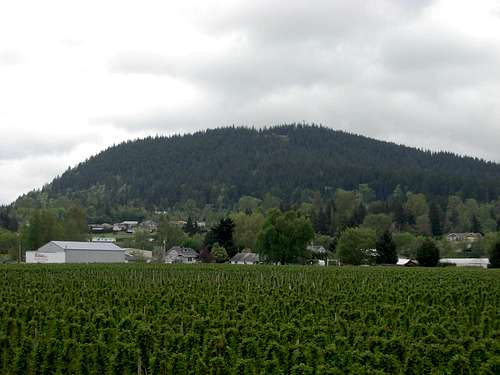 Little Mountain
Most of the mountain, including its entire upper half, has been designated as "Little Mountain Park". At approximately 480 acres, Little Mountain Park is Mount Vernon's largest city park. The park has two major access possibilities: by road or by trail. There is only one road within the park boundaries, and that road leads 1.5 miles up to the summit and two viewpoints. The summit road is accessible for motorized and non-motorized use, and is open daily year-round between 10:00 AM until dusk, except during periods of snowy/icy conditions.
 Communications Towers On Summit
Multiple hiking trails also exist on the mountain of varying distance and difficulty, allowing plenty of recreational walking and hiking opportunities for visitors. This includes a 2.5-mile roundtrip summit trail. The summit trail is the most used trail on the mountain, is considered easy-to-moderate difficulty (depending upon fitness level), and passes through thick second-growth forest. The true summit of Little Mountain is actually where the communications towers are located, but that fenced-in area not open to public access. However, public-access trails do exist that circle around the communications towers fenced area.
A full trail map is available at the following website: http://www.littlemountainpark.org/map/
 Upper Trailhead For Summit Trail
The summit has a long history of human influence. Before the 1900s, local Native American tribes regularly visited the tiny peak for hunting and as a viewpoint for the Skagit River lowlands. Later, settlers did the same. Later still, the Washington Division of Forestry {(which later became the Washington Department of Natural Resources (DNR)} constructed a 100' tall wooden fire lookout tower on the summit. The tower had a 7' x 7' cab and shake cabin. In 1942, due to the mountain's convenient location and ease of access, an Aircraft Warning Service (AWS) cabin was added at the summit with a purpose of watching for any enemy aircraft that might approach the region's nearby coastal waters during World War II. In 1980, the lookout tower and cabins were destroyed by the DNR.
 A View From Pickering Viewpoint
During the mid-1980s, a gazebo and picnicking area were established at the summit, with south-facing views. The South Viewpoint is officially called "Pickering Viewpoint", in honor of the "Frank C. Pickering Trust Fund" donating money in 1986 for the construction of the south-facing retaining wall at the summit. Also, with the peak's close proximity to Mount Vernon, the summit became an ideal location for several communications towers. Later, a north viewpoint ramp was constructed in 2004 and then officially opened in 2005 near the summit area, overseeing the city below.
 North Viewpoint
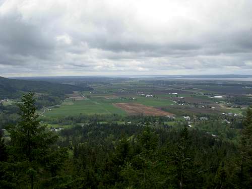
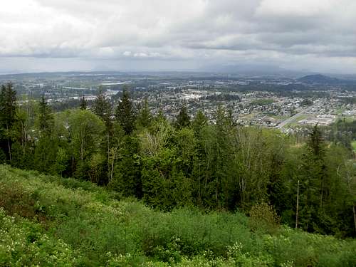
On a clear day, views from the summit area include Mount Vernon, Skagit River valley, Olympic Mountains, San Juan Islands, and Mount Baker. The summit area has also been known to be an interesting far-range viewpoint for the region's vast colorful tulip fields during early Spring months.
 A View From North Viewpoint Ramp
Little Mountain is locally popular as a destination for hikers, bikers, picnickers, birdwatchers, and even hang-gliders. The South Viewpoint, also known as Pickering Viewpoint, still has a concrete ramp near it that used to be very popular with local hang-gliders as a launch spot (until safety concerns caused the ramp to be fenced-off).
 Hang-Gliding Ramp At South Viewpoint
 Looking Down Hang-Gliding Ramp...
Getting There
FROM MOUNT VERNON OR FROM NORTH OF MOUNT VERNON:
1) From I-5, take the "Kincaid Street" exit, near the south/downtown section of Mount Vernon, WA.
2) Head east and uphill along Kincaid Street for approximately 0.7 miles.
NOTE: Once uphill out of the downtown area, Kincaid Street turns into Broad Street.
3) Turn right (south) on South 18th Street. Follow for approximately 0.6 miles.
4) Turn left (east) on East Blackburn Road. Follow for approximately 0.6 miles.
NOTE: Little Mountain will be the hill seen south of the road.
5) Turn right (south) on Little Mountain Road. Follow for 0.3 miles, and then veer right and uphill onto an unmarked road (the Little Mountain summit road) to enter Little Mountain Park.
 Little Mountain Park Entrance Sign
FROM SOUTH OF MOUNT VERNON:
1) From I-5 heading northbound, take the "Anderson Road" exit.
2) Take a right onto Anderson Road, then soon afterwards turn left onto Cedardale Road and head north.
3) Cedardale Road ends at Blackburn Road. Turn right (east) onto Blackburn Road and follow for approximately one mile.
NOTE: Little Mountain will be the hill seen south of the road.
4) Turn right (south) on Little Mountain Road. Follow for 0.3 miles, and then veer right and uphill onto an unmarked road (the Little Mountain summit road) to enter Little Mountain Park.
 Lower Trailhead Near Entrance Gate
Red Tape
Little Mountain Park is open all year. There are no fees or permits needed to hike or drive on Little Mountain.Little Mountain Park is open daily, 10:00-Dusk. However, the entrance gate and road might be closed to motorized traffic during times of inclement weather and road conditions. The summit (hiking) trail begins right before the entrance gate.
For current rules, regulations, and trail updates, please visit the Little Mountain Park website: http://www.littlemountainpark.org/
peter@parallelcreative.com - May 5, 2016 12:29 am - Voted 10/10
Out of date contentHi , A page on your site - http://www.summitpost.org/little-mountain-trail-map/778825 - includes an old trail map for Little Mountain Park in Mount Vernon. The trail system has been significantly expanded over the past few years and some trails have been rerouted. Since more new trails are in the works so, you might want to consider just linking to the map page on our new website: http://www.littlemountainpark.org/map/ Please let me know if there’s any other info I can help with. Cheers, Peter Wheeler Board Member, Mount Vernon Parks Foundation
Redwic - May 5, 2016 3:05 am - Hasn't voted
Re: Out of date contentHi Peter. I was just telling my wife last week how much the trail system has expanded and I planned to add more information on this page. I appreciate you providing that link. Thank you.
peter@parallelcreative.com - May 21, 2016 5:46 pm - Voted 10/10
Re: Out of date contentGlad you found it useful. Hope we see you at our trail builders fundraiser on June 4th!