
|
|
Mountain/Rock |
|---|---|
|
|
47.36697°N / 121.54037°W |
|
|
King |
|
|
Hiking, Skiing |
|
|
Spring, Summer, Fall, Winter |
|
|
4586 ft / 1398 m |
|
|
Overview
Little Saint Helens located off of Exit 47 on I-90 is one of the lesser known summits in the region. It is not a very popular summit due to the fact that there is no true organized trail to the summit and the fact that there is a number of forest roads that go around the summit. As of 2011 there are now attempts to make this peak more accessible to the public by putting a trailhead up at the base of Little Saint Helens and improving some of the forest road and turning them into mountain bike path.
The peak also lacks some of true mountain feel that many other mountains in the region have. First the mountain has been heavily forested. In summer you really have to stay on the roads much of the time or be prepared to deal with second growth forest and nasty devils club. Also the fact that this road contains a heavy amount of forest roads makes it not very desirable in terms of the nature aspect. With so many other mountains in the region containing a much more natural setting this mountain usually is skipped by many. My personal opinion is that is summer skip this peak because there are so many others in the region that are more desirable.

In winter though this mountain becomes a much better destination. The winter season opens up two routes to the summit. The first route is the winter route which is basically a snow climb up from the John Wayne Trail up the northern ridge of the mountain. Provided there is good snow at the base this can be quiet a rewarding snow climb and due to its closeness to Seattle and lack of popularity it can be quiet rewarding. The other way is via the Hansen Creek road which contains a 3 mile road walk or drive up if you have a high clearance 4X4 hummer or snowmobile up to the summer trailhead and going up the peak directly through the second growth forest. The avalanche here vary depending on how open the route is. I would not climb here is the avalanche danger is approaching high.

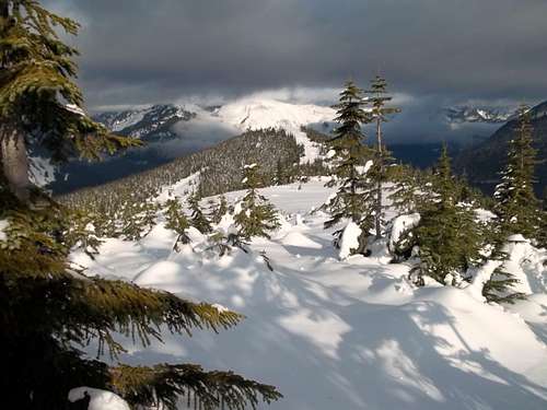
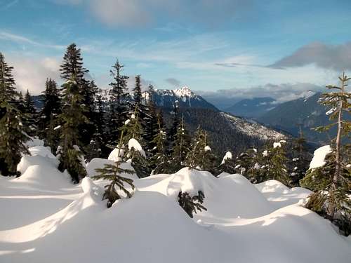
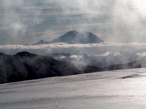
As for the views they are rewarding especially in winter. Both literally just north of the summit and a little to the south of the summit are excellent 180 degree views due to the open fields. The northern views contains excellent shots of Bandera, Granite and Defiance. The southern open field contains excellent views of Rainier and many of the southern peaks. Both sides contain good views of Bear scout (Mount Baldy), Silver and Humpback to the east and Mount Gardner, McClellan Butte, and Mount Kent to the west. The absolute true summit is limited in the views is block a group of trees to the south of it, however the two fields more than make up for the views. On a personal note save this mountain on your wish list for the winter when snow gives this mountain a more appealing touch.

Getting There
Get off of Exit 47, the same exit that the more popular trailhead such as Granite Peak are located. Make a right when heading of the ramp. Head down the road roughly 300 yards. Once you run into the T-intersection make a right and head west the road is a dirt road but as of 2011 the road is in very good condition. Stay on the road for roughly a mile. From there make a left onto another well established dirt road. From there take that road roughly 3 miles. You will pass the parking section for Humpback and then another dirt road along the way. The road will head south and be on the eastern side of Hansen Creek for most of the way. Take all the way to the marked tralhead located at the foot of Little Saint Helens. It should be noted that this road only passable in winter by a 4x4 and Hummer in winter and is many time passable after a major storm.If going for the true winter route you park near the T- section and then hike up to the trestle bridge located a couple hundred yards to the south.
Red Tape
No Red Tape here. Be prepared though to be sharing the parking with those who practice fire arms in region here. Also in December a lot of people will take this road up to cut down their Christmas trees so be aware of this. That being said the people I ran into tend to be quiet respectful of hikers.Camping
Camping is legal provided there is no tresspassing of the watershed. On the summit area there are a couple of open fields both to the north and the south.External Links
A good report of the peak from Eric WillhiteA good winter report from Little Saint Helens
Northwest Weather and Avalanche Center
Baarb - Dec 5, 2011 11:50 am - Hasn't voted
Lookslike a nice day out. Perhaps adding captions to the pictures on the main page would be helpful in explaining what they're of / illustrating as one reads through. Clicking on each or looking for the photo name in the web address breaks things up a bit. Cheers.