
-
 8643 Hits
-
 88.19% Score
-
 26 Votes
|
|
Mountain/Rock |
|---|---|
|
|
37.73219°N / 118.56876°W |
|
|
Trad Climbing |
|
|
Spring, Summer, Fall |
|
|
7800 ft / 2377 m |
|
|
Overview
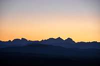 The Minarets, Mount Ritter and Banner Peak are seen from the road to Locals Only Rock.
Locals only is a rock formation located some ten miles from the town of Benton, and thirty miles from the town of Mammoth Lakes, California.

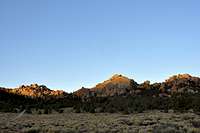
 Locals Only Rock
Locals Only Rock may come as a complete surprise to a climber looking for high quality rock in the middle of a heavily volcanic region. Locals Only Rock is but one of the many rock formations in an area known as Benton Crags. The formations are identical to the type of granite you find in Joshua Tree National Park, very grainy and well featured. Locals Only Rock, in particular, is less than 90 degrees with good holds, cracks and flakes. The biggest differences to Joshua Tree are the size and altitude. At nearly eight thousand feet, Locals Only is a great place to climb in the warmer seasons.
The drive to Locals Only Rock will take you through some of the most desolate areas of Owens Valley of California. The road is a beautiful paved two-lane highway passing through pinion forests and volcanic formations. You will pass by a sheep farm and a ranch complete with a wind mill. The only road signs you will run into will urge you to “Share The Road.” My feeling is that because this road is not traveled very much, the locals drive in the middle of the road and fast. Fortunately, my wife and I didn’t have to evade any such drivers.
 | |  | 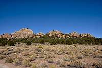 |
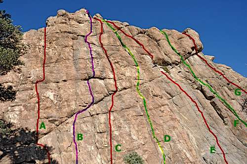
Routes of locals Only Rock
The history of climbing on Locals Only Rock dates back to the early 1980’s. The first ascents were done by a handful of climbers. As it is unavoidable with any new climbing area, I have no doubt it took a great deal of hard work and dedication to clean the rock and cut a path through the pinion forest to establish access to these rocks.
Locals Only Rock is about one hundred and fifteen feet in height and sports several moderate climbs from 5.6 to one 5.10a. You will not find any sport routes on this rock. You need to protect the climbs using your own gear. Taking extra slings is highly recommended as you may zig zag up most of the routes. There are two bolt-anchors on top to use for belaying and rappeling. However, these two anchors are for the climbs on the left side of this rock. You need to be prepared to set up your own anchor for the climbs ending on the right side of this rock.
The most highly recommended route on Locals Only Rock is called “Surfin Safari,” rated 5.9.
This route is located on the right side of the formation and climbs up cracks, corners and sections of face to the top.
Locals Only Rock | |
| A | Pipeline, 5.8, Standard rack, pro to 3 inches |
| B | Locals Only, 5.6, Standard rack, pro to 3.5 inches |
| C | Get Lost, 5.7, Standard rack, pro to 3 inches |
| D | No Trespassing, 5.8, Standard rack, pro to 3 inches |
| E | Surfin Safari, 5.9, Standard rack, pro to 3 inches |
| F | Tough Muffin, 5.9, Standard rack, pro to 3 inches |
| G | Low Cal, 10a, Standard rack, pro to 3 inches |
| Note | There is another climb to the left of Pipeline that could not be shown in the photo. Tube, 5.6, bolt anchor, Standard rack, pro to 3 inches |
 Locals Only Rock-extreme left Locals Only Rock-extreme left |  Locals Only Rock, left side Locals Only Rock, left side |  middle middle |  right side right side |  Mary on Surfin' Safari, 5.9 Mary on Surfin' Safari, 5.9 |
Camping
Benton Crags are located within National Forests and you can camp anywhere you want. However, fire restrictions are in place. You may acquire a fire permit from Bishop Ranger Station in the town of Bishop, or the ranger station in the town of Mammoth Lakes. Benton Crags are within a pinion forest with no water or facilities. Most people prefer to use the campgrounds closer to Highway 395. There are a number of Campgrounds within the town of Mammoth Lakes, and many more in the nearby towns. The following links should help find a suitable camp.http://www.tripadvisor.com/Attraction_Review-g60791-d1119984-Reviews-Mammoth_Lakes_Visitor_s_Center-Mammoth_Lakes_California.html
you ask about Lake George campground and Lake Mary campground,
Or,
you may want to try the following links for camping outside of the town of Mammoth Lakes:
Horton Creek Campground
Rock Creek Canyon
Inyo National Forest
Bishop Creek and vicinity camping
How to get there
If you are going to climb on any of the Benton Crags, chances are that you are using Mammoth Lakes as your jumping off point. Therefore, the directions given here assume that you are starting from the intersection of Highway 395 and Highway 203, the main road leading to Mammoth Lakes.From the intersection of Highway 395 and Highway 203 drive south on HWY 395 for 5.5 miles to its intersection with “Benton Crossing Road.” You will see a small church on your right. From this intersection drive another twenty four miles past Crowley Lake and pinion forest to “Barker Mine Road,” which is shortly after the sign “Wildrose Summit.” Barker Mine Road is actually the National Forest Road (3S50) and it’s a dirt road. From here you will see several of the formations that make up Benton Crags. Drive .4 miles to another dirt road. Turn left here and drive .8 miles past at least two forks in the road heading left. Stay on the main, wider dirt road for this .8 mile stretch. You will come to a fork. Take the left one for another .3 miles to a good turn around/primitive camping area. It is important to know that fire restrictions are in effect. Locals Only Rock is visible behind the trees from here and it’s a short walk up a steep and sandy hill.