
|
|
Mountain/Rock |
|---|---|
|
|
40.69510°N / 111.018°W |
|
|
11342 ft / 3457 m |
|
|
Overview
Long Mountain is one of the peaks in the Western Uinta Mountains. It isn't officially named, but does have a benchmark marked "Long" on the topo maps. The mountain has three main individual peaks. The central peak is the highest at 11,342 feet elevation, followed by the north at 11,327, and then the east at ~11,150. The peaks are nice scrambles and can be approached from almost all directions and from many trails. The western section of the Uintas doesn't have near as high peaks as the central sections, but the peaks are still interesting.The Uinta Mountains are one of the few mountain ranges in North America that run east to west rather than north to south. Within the Uinta Mountains are about 2000 lakes, and some 900-1000 are full of trout. Along with the San Juans in Colorado, the Uintas have more contiguous area above timberline than any other area in the Continental United States. This is a beautiful area with many lakes, meadows, wildflowers, and some rugged peaks.
 Anchor Lake and ridge north of Long Mountain.
Getting There
Upper Setting TrailheadThe Upper Setting Road takes of north off Highway 150 8.7 miles east of Kamas. The lower section of this gravel road is good for passenger cars, but the upper half of the road is suitable only to high clearence vehicles. There are many side tracks, but follow the main track to its end.
Norway Flats Trailhead
The Norway Flats Road branches off the north side of Highway 150, 10.6 miles east of Kamas. There is a sign marking the road. The road is good for the first mile, and then it quickly deteriorates into a 4wd road. Follow the 4wd road north staying on the main road that is marked for 4wd's (staying away from the forks marked for ATV use). Near the end of the main road there is a junction. Turn right along a less used road and follow the road to its end. If you reach a large lake, you're in the wrong place. Turn around and backtrack a short distance to the last junction and follow the less used road to its end. At the end of the road is a vehicle barrier trench and a singpost without a sign (late 1990's). This old blocked off road is the beginning of the trail.
Crystal Lake Trailhead
Crystal Lake is reached from the Trial Lake spur road off Highway 150 25.7 miles east and north of Kamas. Follow the signs along the spur road to Crystal Lake. This gravel road is good for all vehicles.
Middle Fork Weber River Trailhead
From Oakley (State Route 32), turn east on the Weber Canyon Road. Follow this road east for about 12 miles to where the Smith and Morehouse Road turns south. Go straight and pass under the big ranch gate that says "Thousand Oaks Ranch". This is a public road, the ranch just wants to make it look private. Read the sign that informs you that either side of the road is private land for the next several miles. The land between Thousand Oaks and Holiday Park is private, so stay on the main road and don't camp along it. Follow the good gravel road to Holiday Park. Once at Holiday Park, follow Uinta Road to the parking lot and outhouse at the trailhead. Do not cross the river on the 4wd road, look for a sign pointing out the trail to Abes Lake and Crystal Lake.
Gardners Fork Trailhead
First, drive to the Middle Fork Weber River Trailhead as descibed above. You will need a 4wd for the remainder of the drive, unless the road has been recently improved by the forest service. From the parking lot described above, drove to the west end of the parking lot and cross the river. The crossing used to be really rough, but the forest service has done work on it in recent years. Follow the road west to a junction and turn left. There is a sign pointing the way to Gardners Fork. Follow the road southwest to another junction. Both tracks meet up eventually, so either fork is fine. There are also a few short dead end side tracks, so some backtracking might be necessary. Do not take any of the side tracks that head too far away from the stream. Drive as far as you can and park. In the late 1990's, the best place to park was went a cliff was just west (right) of the road, but rumor has it that the road is not as rough as it used to be.
Smith and Morehouse Trailhead
The trailhead is at the Ledge Fork Campground. From Oakley (State Route 32), turn east on the Weber Canyon Road. Follow this road east for about 12 miles to where the Smith and Morehouse Road turns south. Turn right (south) at this junction and follow this good gravel road past the Smith and Morehouse Reservior. The road ends at the Ledge Fork Campground and the trailhead.
 Long Lake and ridge east of Long Mountain.
 Routes Overview
Upper Setting RouteThis route begins at the East Upper Setting Trailhead, follows the trail to West Shingle Creek Lake, over a low pass to Erickson Basin, over Big Elk Pass, down to Big Elk Lake, along the trail east, and climbs to near Island Lake and approaches Long Mountain from its SW ridge.
Norway Flats Route
This is the shortest route to Long Mountain. The trail heads north to Big Elk Lake, at which point it joins the Upper Setting Route.
Crystal Lake Route
This is the route from the east. From Crystal Lake, the trail heads west over Watson Pass, west to Long Lake, west to Island Lake. From Island Lake, either the SW or SE ridge of Longs can be used to reach the summit.
 South ridge of Long Mountain from Long Lake.
Middle Fork Weber River Route
This is a more solitary route to Long Mountain. This route follows the trail/route along the Middle Fork River to its head. Trails near the headwaters are either hard to find or non-existant, no matter what the topo maps may indicate. Once the headwaters basin is reached, several routes can be taken. You can head west along the base of the ridge until you are north of the saddle between Long and East Long Mountains. From there, you can cimb to the saddle and then follow the ridge west to the summit. You can also hike to the very broad saddle between Mount Watson and East Long Mountain. From there you can climb west up to the summit of East Long Mountain, then continue along the ridge to the summit of Long Mountain.
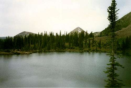 Anchor Lake with Long Mountain in the center.
Gardners Fork Route
This is another seldom used-trail/route. The trail is good to Fran Lake, but mostly fades beyond. The route will stay along the base of the ridge to the west. The route passes Rhodes Lake, Olsen Lake, south to Anchor Lake, and further south to the saddle between Watson and East Long and the routes mentioned above. From near Anchor Lake, you can head west to Hells Kitchen Pass, and then follow the scenic ridge south over North Long Mountain, down to a saddle and then south to the main summit.
Smith and Morehouse Route
This route goes up the main Smith and Morehouse Trail southeast to near Island Lake. From near the minor saddle near Island Lake, the SW ridge of Longs can be used to reach the summit.
Guidebook
More details about the area can be found in the book Western Uinta Backcountry Guide, including many routes to the summit, and hiking trails to the many lakes, and fishing information. Just send me a PM if you want to purchase the book.SP members can have the book for 1/2 price, and there is no shipping cost.
 Guidebook
Red Tape
For the southern routes (the first three trailheads above), and for traveling Highway 150, there is now a $3 per day use fee for parking along the highway. There is no red tape for the other routes.When To Climb
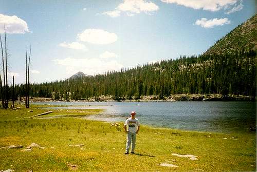
July through September is the normal hiking season here. All trailhead roads above are closed in winter. The best route in winter might be to snowshoe or ski up the Norway Flats road from Highway 150. The round trip distance in winter would be about 22.4 miles and would be a three-day trip for most. Along the Middle Fork Weber River route in summer.
Camping
There are many campgrounds along Highway 150, but they can be crowded and full on summer weekends. There is also a campground at Smith and Morehouse Reservoir. In addition to campgrounds, there are several primitive camping sites on each route described below.Upper Setting Route
There are campsites along the Upper Setting Road. In the backcounrty, there are some good campsites along the way to East Shingle Creek Lake and near a lily pad pond. There are good campsites at East Shingle Creek Lake. Erickson Basin has many really good campsites. BIg Elk Lake has some campsites on it's southwest and east sides.
Norway Flats Route
There are some campsites along the Norway Flats Road. Good campsites are found along the trail and in the meadow .5 miles from the trailhead. This route joins the Upper Setting Route near Big Elk Lake (see above).
Crystal Lake Route
There are many good backcountry campsites throughout the area. Long Lake campsites are a bit over-used, so you may want to look elsewhere. Island Lake is very popular as well, and can be crowded.
Middle Fork Weber River Route
There are many backcountry campsites right along the Middle Fork Weber River. In some sections a long the river, campsites are a little scarce, but there should be some nearby on any section of the river. If you take the Anchor Lake route, there are some secluded campsites at Adax Lake. This route joins with the Gardners Fork route just north of Anchor Lake, so see the Gardners Fork section just below.
Gardners Fork Route
There are some campsites along the Gardners Fork road on the way to the trailhead. There are a few backcountry campsites along the route to Fran Lake. Fran Lake, Rhodes Lake, and Olsen Lake all have some nice campsites. There are some secluded campsites in the meadows between Olson and Anchor Lakes. Anchor Lake has only a few campsites, but there is more room in the meadows east and below the lake.
Smith and Morehouse Route
Large campsites are a bit scarce on the lower section of the trail. The upper basin has some good campsites, but some of the smaller streams can dry up in late summer. There is still water around, but you will have to leave the trail and head aways west to find it.
 Many good backcountry campsites are available.
Mountain Conditions
Contact the ranger station in Kamas for current road and trail conditions. Their phone number is 801-783-4338.WEATHER FORECAST FOR WESTERN UINTA MOUNTAINS
Here are some average highs and lows from Mirror Lake at 10,190 feet :
| MONTH | HIGH | LOW |
| JAN | 23 | 0 |
| FEB | 25 | 2 |
| MAR | 29 | 6 |
| APR | 38 | 14 |
| MAY | 47 | 22 |
| JUN | 57 | 31 |
| JUL | 67 | 38 |
| AUG | 65 | 37 |
| SEP | 57 | 30 |
| OCT | 46 | 19 |
| NOV | 32 | 10 |
| DEC | 26 | 4 |