Lost in the Darkness
The story of our adventure starts out in Late September. The Division of Wildlife Resources contacted me for help to retrieve a radio collar located high on Outlaw Peak in Dinosaur National Monument. The DWR and National Park Service Rangers were unable to find a route up there (or to get a helicopter to retrieve it) so they contacted me for help since I have explored the area extensively and had climbed Outlaw Peak (which has had only two known ascents). They had flown over the collar and knew the approximate location. It seemed like a challenging but simple enough task and I offered to help, but my real job kept getting in the way and I could never seem to get out.
On foot, the best time for exploring this extremely rugged country is late August through mid-September when the Yampa River is low and not too cold yet, but as time went by it seems the chances of getting away to go look for the collar became slimmer and slimmer. Unfortunately, I was also told that the collar might not still be transmitting by spring time and a winter trip to the area is completely unfeasible most of the time. The collar was located just to the east of the summit bock of Outlaw Peak and only a few people have ever been there, so I hoped I could help.
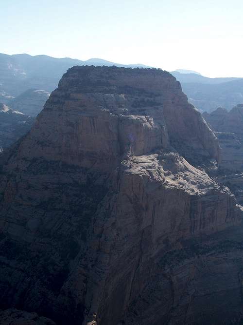
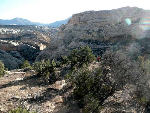
![Outlaw Peak]() Towering above the mighty Yampa River is the mighty Outlaw Peak, which has had only two known ascents. The collar is on a broad bench on the right shoulder of the peak that can be seen upper right. We would not have to climb to the very summit to retrieve the collar.
Towering above the mighty Yampa River is the mighty Outlaw Peak, which has had only two known ascents. The collar is on a broad bench on the right shoulder of the peak that can be seen upper right. We would not have to climb to the very summit to retrieve the collar.
By late November I could finally get away, but I didn’t want to try something of this difficulty alone. My coworker Justin Kuhn had done a few short trips of some of the desert peaks around Craig and expressed some interest in helping out so we planned to get out as soon as we could (we were both working on the same project). The day finally came on November 22, but could we do it? I had my doubts. The river might be too cold and high to cross and a one day trip at this time of year would not be easy. I had done a similar one day trip with Jeff Fox when we went to go measure Outlaw Arch, but that was in late September and we still returned after dark.
Since we only had one day at our disposal (we had usually been working long days 6-7 days a week for several months) we would have to get up very early and try to do the entire trip in one day. After packing up we met in the morning at 5 am so we could drive out to the trailhead and hit the route as soon as it got light.
The first event of the day was that we got a flat tire just before reaching the trailhead in the morning which cost us over an hour of valuable daylight. We quickly started on the route as soon as the tire was fixed.
As mentioned, I have been in the area several times, but usually in August and September with longer days and warmer mornings and nights and because we were going in late November, we were carrying a lot more extra gear (all of which was used and needed) and had much heavier packs. It made the going slower than in previous trips. We were also carrying the collar locating equipment. Because we would be wading (or swimming!) the Yampa River twice we brought along full wetsuits, which are bulky and relatively heavy.
(Note: Because of the time factor we got few photos of the November 22 trip, so I will use some from previous trips to fill in the gaps).
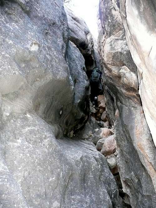
Because of the late hour we decided to try the most direct route to the Yampa River, which involves several downclimbs and a hidden and very steep chute that forms the Access Gully (other people I have taken down the route have a less nice name for the gully). We made our way cross country through the rugged country, down a canyon and up and over the saddle to the access gully. While we were climbing up to the saddle Justin asked why we couldn’t continue down the canyon, but I informed him that the canyon ends in a 600 foot vertical drop straight down to the Yampa River.
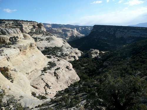
![Descent canyon]() This is the descent canyon that we used before climbing up to the very steep chute. The upper part of the canyon is easy, but since it shoots off a 600 foot cliff, it can't be followed all the way to the Yampa River.
This is the descent canyon that we used before climbing up to the very steep chute. The upper part of the canyon is easy, but since it shoots off a 600 foot cliff, it can't be followed all the way to the Yampa River.
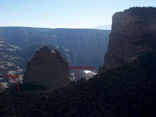
![Route to access gully]() This is the location of the hidden access gully which forms the most direct route to Outlaw Park. The actual gully is hidden and can’t be seen in the photo.
This is the location of the hidden access gully which forms the most direct route to Outlaw Park. The actual gully is hidden and can’t be seen in the photo.
We climbed up to and descended (easier said than done!) the steep gully to the Yampa River. Jeff Fox says it best in his trip report from our September 2006 trip (although this time was cold rather than hot):
From here on out, the terrain got worse. It was steeper, it was more loose, rugged, hot and treacherous. Immediately we had to ascend a steep narrow gully that was choked with boulders, trees and bushes. The climbing was difficult to say the least. Hoisting oneself up and over large boulders that are wedged between the walls of a slot is one thing, doing it with a large pack is not fun. I don’t know how many times my pack got caught on the trees we were climbing out from under. You had to pay attention to hand holds too. The rock was rotten, soft and loose.
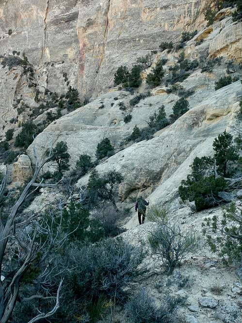
![Approach]() Descending into the head of the gully. It gets more difficult below this.
Descending into the head of the gully. It gets more difficult below this.
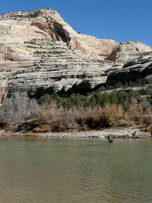
This time, in late November we even had more gear with us. Justin and I took a break at the river and took time to change into our wetsuits and bag our gear for the icy cold crossing of the Yampa River. I went first and found it to be belly deep with some careful feeling around with a walking stick. It was pretty hard to stand up, but other than that not that bad and easier than expected. Justin followed but failed to find the extra neoprene socks I had brought so he crossed without them. His feet were freezing and aching by the time he reached the other side of the river. We ate a snack and quickly headed up to find a break in the first cliff bands on the north side of the river.
![Cold Crossing]() Crossing the very cold Yampa River.
Crossing the very cold Yampa River.
We found a new route up the cliff bands west of the routes I had used previously. There was a narrow chimney to climb that was a struggle, but it was less exposed than the original route we used to climb the cliff bands farther east. We also found a really cool new arch that I hadn’t been close to before and had only seen from a distance on earlier trips.
![First cliff band]() Climbing the chimney in the first cliff band. This route was a bit easier than the route we used in previous trips so was a good route to take.
Climbing the chimney in the first cliff band. This route was a bit easier than the route we used in previous trips so was a good route to take.
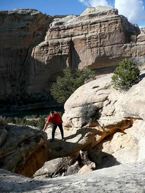
![Arch]() That's me on a neat little arch we found after climbing the chimney in the first cliff band.
That's me on a neat little arch we found after climbing the chimney in the first cliff band.
Now that we climb the first cliff bands it was just up, up and up switching back and forth between various ledges, cliff bands and slickrock until we got to the crux area. About half way up the ledges and cliff bands, we sat down in a scenic area for lunch at 1 pm. We were still moving at a slower pace than was hoped.
I explained to Justin: “I think this is the point of no return as far as getting back before daylight goes. If we continue there is no way we could get before dark”.
“How is the route out of here”?, Justin asked.
Me: “Not bad. Lots of elevation gain. Once we find the collar the quickest way out is Outlaw Canyon and back to the river. We would have to hurry fast in order to get to the top of the rappel before dark. We don’t want to do that part of the canyon in the dark. After reaching the river (through Outlaw Canyon), we’ll take an easier way out than coming down that gully” (the one we came down before crossing the river). I pointed over to the rock point and cliff bands across the river from Outlaw Canyon. “Our route is over there. It is a longer and less direct route, but it’s easier (relatively speaking). Once we are up and out of the cliff bands the route is easy and then it’s just an up and down walk to the vehicle”.
Justin: “Let’s go get the collar. It’s what we came to do, right?”
Me: “Let’s go”.
We then put our packs on and climbed up to the exposed ledges near the crux saddle. I am now quite familiar with which ledges to use since I have now crossed the ledges several times. The ledges aren’t that difficult, but are very exposed and one misstep has a 600 foot penalty.
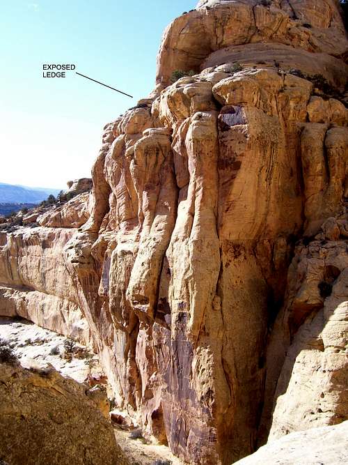
![Ledge]() This is one of the exposed ledges on our route.
This is one of the exposed ledges on our route.
We crossed carefully crossed the exposed ledges and made our way down the very steep chute to what used to be one of the hardest parts of the route. At that location just before the final ledge to the Key Saddle there used to be a choice of two routes. You could either do a scary ledge traverse or hug an overhanging boulder and step over a scary gap with a sizable void underneath. This time we found that the “step over crack” had been filled in by a large rockslide sometime between September 2006 and November 2008. We simply walked over the gap over loose rubble (you must be careful because the rubble is loose, but the route is easier and less scary than it used to be).
![Desceding to the final ledge]() This is me descending to the final ledge just before the Key Saddle. We have just completed the exposed crux ledge adn now have to descend a steep rockslide.
This is me descending to the final ledge just before the Key Saddle. We have just completed the exposed crux ledge adn now have to descend a steep rockslide.
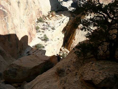
![Finding the collar]() This is me setting out to find the bighorn sheep collar with the locator equipment.
This is me setting out to find the bighorn sheep collar with the locator equipment.
The “fun” was still not over. Now we had to descend a very steep and brushy slope to another bench and traverse the bench along a deep drainage. The route down is has enough brush to remove skin, but this time we were wearing long pants and so we only lost a little blood. After our traverse we had to climb two more cliff bands. The first was a tricky climb up a juniper tree to where we could reach a ledge and scramble up. We then traversed to the head of the drainage to what was probably the single most difficult move on the route. It was a steep climb up a loose chimney. All that was left was the comparably easy long bench traverse up to the open and hidden plateau guarded by Outlaw Peak.
Justin was exhausted so he sat down to rest while I set up the locating equipment and set off to try and find the collar. It was already 2:20 PM and we only had three hours of daylight left and I looked for the collar for almost an hour. I passed up and down steep ledges and over open flat slopes, but couldn’t find the collar. I must have walked several circles, but it was time to leave, collar or not.
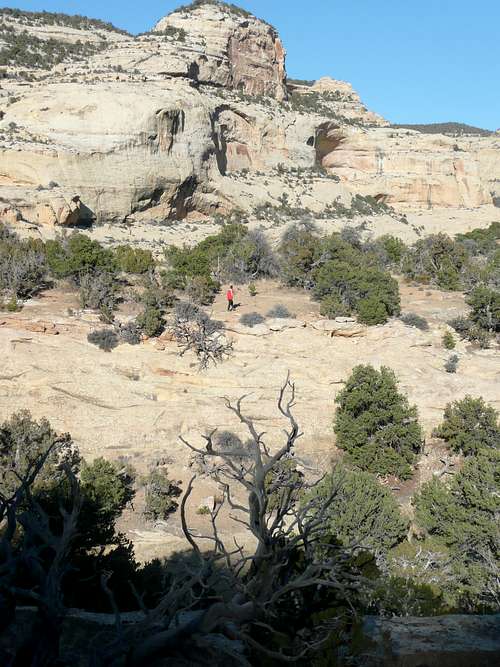
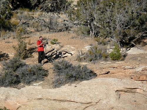
![Looking for the collar]() This is me attempting to locate the bighorn sheep collar with the locator equipment.
This is me attempting to locate the bighorn sheep collar with the locator equipment.
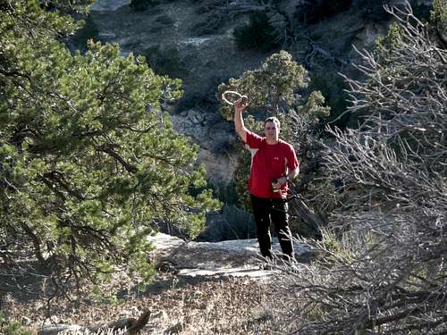
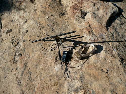
![Collar found]() That's me with the locating equipment and the bighorn sheep collar which we found.
That's me with the locating equipment and the bighorn sheep collar which we found.
I headed back towards Justin who was on the flats next to a cliff and kept the radio collar on. Right at the last minute I saw something half buried in the sand. It was the collar! We had found it. Justin was out headed towards me when I found the collar and I drank much water and we were both excited to have found it. By now though, it was already 3:15 PM and the cliffs were already casting long shadows. We would have to really move in order to make the top of the rappel by dark.
![Collar and locating equipment]() This is the bighorn sheep collar and the locating equipment.
This is the bighorn sheep collar and the locating equipment.
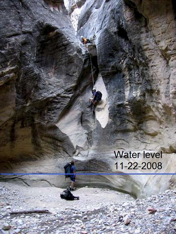
![Outlaw Canyon]() This is a September 2 2006 photo of the rappel in Outlaw Canyon. On November 22 2008 the water level was as shown and there was a huge wimming pool sized pool of ice cold water, but by now it was too dark to get photos.
This is a September 2 2006 photo of the rappel in Outlaw Canyon. On November 22 2008 the water level was as shown and there was a huge wimming pool sized pool of ice cold water, but by now it was too dark to get photos.
We took a lower ledge below the cliffs and traversed south and around to a drainage. We followed the drainage and an exposed and steep and exposed ridge down to the bottom of Outlaw Canyon. Amazingly the bighorns also use this route.
Unfortunately, Justin sprained his ankle on the steep way down to the floor of the canyon floor. This would slow us down a bit, but we still crossed our fingers that we would be to the top of the rappel by dark.
Outlaw Canyon down to the top of the rappel is a scenic corridor with just typical bouldering in normal conditions. This time we found the canyon had ice covered pools to either cross or traverse around. One large ice covered pool just looked too cold to swim through. We found a narrow ledge (not much wider than a boot) on the left wall of the canyon. I tried the ledge first. It was rather un-nerving as we had to duck while hugging the wall above the icy pool. A fall here would only result in maybe an 8-10 foot fall, but it would be into an ice covered pool which was not exactly appealing just before it was getting dark in late November.
After passing another pool we were on our way downcanyon. When the canyon narrowed to a slot we knew we were near the rappel. We were elated and very glad to be close since the sun had gone down and it was just getting dark. Relief! Just one more corner…….elation immediately turned to disappointment and hit us like smack in the face as we looked off the drop. Below the drop was a huge swimming pool sized pool of cold brown water. This would not be pleasant.
Reaching the top of the rappel and eying the huge pool of water was a letdown, but there was only one thing we could do. We dry-bagged our gear and dawned our wetsuits while occasionally giving disgusted looks to the big brown pool. Floods had rearranged the rocks, so I spent some time reconstructing the rappel anchor in the fading daylight. We decided the easiest and quickest way to negotiate the obstacle was for me to lower Justin down the drop with the belay device and then have him swim across the pool and set up a zipline for the packs. I threw the trekking poles off the drop and into the pool to see if I could throw them across. They made it ¾ of the way through.
The stars were now peeking out as I anchored myself to a boulder and lowered Justin 37 feet down into the cold murky depths of the pool. Justin shouted out some good (and unexpected) news. “I can touch the bottom” he said and also said “if I hug the right wall I think I can make it to the shore of the pool without swimming”. It was good news. “The pool is c-c-c-old” Justin said. After reaching the shore I asked “Justin, can you get the trekking poles?” Since he had just exited the cold water Justin wasn’t that excited to do it, but he retrieved the poles and we set up the zipline for the packs.
Me: “I’ll send a small one first, but pull the line tight”.
I attached a relatively light drybag to the rope with a ‘biner and sent it down the rope. The zipline worked flawlessly so it was nice to know I could rap down without a huge pack. By now it was completely dark except for some starlight. I sent the pack and a drybag on the zipline and sent that down too. By now it was dark dark and down where Justin was standing it was almost pitch black because the canyon is so deep and narrow at that point. I warned Justin that a heavy pack was coming, but since it was now so dark it smacked right into him earlier than expected. I did what any friend would do and laughed a bit before rappelling into the darkness and cold pool.
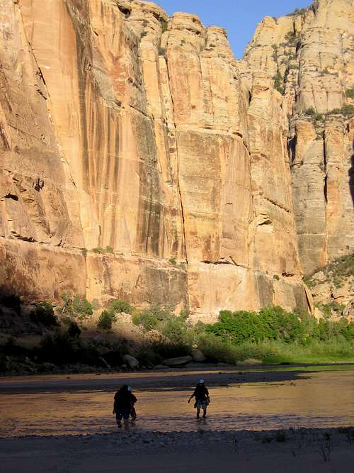
![Wading the Yampa River]() This is the mouth of the deep gorge of Outlaw Canyon (background: right side of photo) where it meets the Yampa River (September 2006). It was completely dark this time (November 22 2008) so we didn't get any photos. The river was much higher in November 2008.
This is the mouth of the deep gorge of Outlaw Canyon (background: right side of photo) where it meets the Yampa River (September 2006). It was completely dark this time (November 22 2008) so we didn't get any photos. The river was much higher in November 2008.
From here down the narrow canyon there were no more technical obstacles, but there was much bouldering. It was not easy in the darkness even with headlamps since the narrow canyon is choked with boulders and drop-offs. At one boulder jam all we could see was a void of black below. I because poking around the boulders and found a small dark hole we could squeeze down. I squeezed down the hole and found that I could chimney down a dark crack behind the boulder and reach the canyon floor. I called to Justin and shown my headlamp and he asked if it was really the way down. It was and was quite exciting at night.
Eventually we reached the final falls obstacle in the canyon which was covered by a wall to wall pool of dark icy water. We could climb down the ledges to the pool and up on the ledges to the left and to a brush covered bench. The brush was thick but we bashed through it until reaching the Yampa River. It was now 6:30 PM and an hour and a half after sunset and we had been going for many hours and were getting tired. The easiest route out of here (though longer) from this location is actually up the Yampa River a bit and up and out Red Rocks Canyon, but the river was higher now than it was at the times I had used that route and I was worried that the water may be too high to do it. We wouldn’t want to get dead-ended and have to retreat in the dark.
It seemed a more sure choice to try the more direct route through the cliff bands that I had found a few years earlier. I was worried about being able to find the route up all the cliff bands in the dark (the night was very dark and completely moon-less), but we would try. It wouldn’t be easy, but I also knew that two years ago Jeff Fox and I were able to navigate similar terrain farther west in the dark (but we had completed the more difficult sections in the daylight).
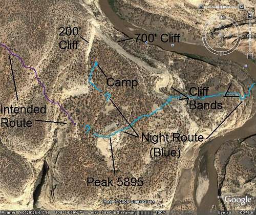
![Lost in the Darkness]() This was our night route (blue), but between the question marks the route we took and where we wandered is a mystery.
This was our night route (blue), but between the question marks the route we took and where we wandered is a mystery.
We crossed the cold Yampa River and rested on the rocks on the opposite side. I had found the descent in the dark of the rugged lower part of Outlaw Canyon was not kind to my wetsuit so it was full of tears and holes which made the crossing colder. My pack didn’t fare so well either. After crossing, we changed out of our wet wetsuits and into the dry clothes that were in our dry bags and sat down to eat some “dinner” (a few granola bars, M&M’s, etc). We also drank quite a bit of water before putting our heavy packs on and heading up the steep slope to the first of the cliff bands. We headed left until we found a place where the cliff was climbable and tackled the pitch directly. We had to take the packs off and haul them up.
After the first pitch it was just a matter of heading up the steep slope to the next cliff band and contouring to the right or left until we found a location where the cliff was climbable. All in all we climbed an additional five cliff bands, each successively harder than the last (in the daylight we probably could have skirted some of the cliff bands) until we reached a large flat area. I had hoped that we were finally through the worst of it and through the cliff bands.
As we headed up the slope slowly the skyline of the mother of all the cliff bands became visible. In the dark the cliff appeared huge and menacing. We were not out of the woods yet!
We headed right and climbed up to some high ledges on the cliff. I took off my pack and headed off some narrow ledges to the right to check out the route feasibility. The ledge pinched out to narrower and narrower until it went around a corner. At the corner the ledge was about a foot wide and pitched at a 45 degree angle and all that could be seen below is a gaping black void. My headlamp would shine down 100 feet or so, but I could not see the bottom and had no idea just how high up we were. I thought to myself “this isn’t going to be fun with a pack”. With shaky knees I carefully crossed the ledge around the corner and was relieved that it became wider. It began to become easy until I was faced with a 10 foot vertical pitch. I climbed the pitch and climbed up a dirty and steep chute and chimney before I finally found myself on top of the wall. I couldn’t spend much time messing around so I quickly headed back down to Justin and the packs. After climbing down the chimney and chute, I used a tree to lower myself down the 10 foot pitch and to the ledge. It was really dark so I shouted to Justin for some guidance. He shouted back and shown his headlamp around until I could see it. I then found the narrow ledge and reversed the route back.
“This is the way” I said.
Justin: “How is the route?”
Me: “It isn’t going to be fun with a pack. We have to cross a narrow ledge” (which I guess was an understatement).
We both headed to the ledge and crossed it quickly trying not to think of the terror of doing it in the dark and trying not to think of how deep the void below us was. When we got to the 10 foot pitch I was tired and Justin and I helped each other up the pitch and hauled the packs up behind. We climbed the chute and chimney and were elated to be on top of the cliff bands. It was now just after 8:00 PM. With any luck we would be back to the vehicle by 10:30 or 11:00 PM. It was not easy and the route wasn’t handed to us without a trial, but we had done it. Not only that, we had done it in the dark and were home free. All that was left was the comparatively much easier rolling route with only several minor scrambles across the desert and to the vehicle. We were very tired but also very joyful since we were done with all the real hardships. We drank some water and pushed on.
We headed off onto the desert flats before I stopped to look at the compass. Elation quickly turned to sudden (but short) despair when I found that the compass had been broken. The compass would do us no good and we were on our own to find our way back on this very dark night. There was no moon at all, but the Milky Way and stars were really brilliant and it made a beautiful scene in a night of stark and harsh beauty.
I thought we could still make it to the vehicle in the dark. All that we had to do was head in the right direction across several drainages to a canyon rim (the canyon we had originally descended part way to the very steep access gully to the river) and follow the canyon rim back to its head. Near the head of the canyon we would follow a ridgeline until we would only be a mile from the vehicle and from there is a very old cowboy fence line that could be followed west to near where the vehicle was parked. All we had to do to get there was to traverse some rugged country through some drainages and make our way to the rim of that canyon.
We headed out west through the desert flats until we spotted another cliff band. “What was this?” I thought. We climbed the (relatively easy cliff band and found ourselves on top of a butte. I pulled out the map and figured that we were on the summit of Point 5895 (on previous trips we had passed to the north of this little butte, but I had forgotten it was there before looking at the map and figuring where we were). We were slightly too far south, but not far off track.
We descended the west side of the butte and headed northwest or at least thought we were headed northwest. It was quickly discovered that finding our way was harder than expected and that every cliff, butte, hill and drainage looked the same in the dark. You couldn’t see the bottom of any drainages so it was hard to figure out which was the right one.
We zigzagged around headed in what we thought was the right direction until we were at the rim of the canyon (or a canyon). We followed the rim a ways and descended slightly into the canyon before returning to the rim. By now we were becoming really exhausted. We pulled out the map on a regular basis and continued on until I saw something on the left. As we got closer I could tell that it was another big cliff.
“Oh no” I said as I could feel my heart sink.
Justin asked “What is it?”
Me: “There is a big cliff on the left. It shouldn’t be there”.
Justin peered through the darkness until he too could make out the cliff.
Me: If we are in the right place there should be a cliff going down to the right, not up to the left”.
We both looked hard at the map. While we are looking I made another observation.
Me: I think I can hear the river”.
Justin: “WHAT? You’re kidding me! We’ve been wandering the desert for over two hours and we must be closer to the vehicle than that”.
I had thought we were following the correct canyon, but this confused me and as soon as we were walled in I knew that I had no idea where we were and that it was pointless to continue wandering without daylight or an idea of our location. It was obviously that we had become lost in the darkness on this eerie and moonless night.
We both looked at the map. I thought the only place we could be was perhaps tucked in a little valley near the river canyon, but how could this be? We had been wandering too long to be not far from where we first topped out on the final cliff bands. It was already past 10:00 PM.
I already knew the answer, but I asked anyway.
Me: “What should we do? Should we stay here the night or try and continue on and find the route? I think once the daylight comes we could easily find out where we are. Every rock, drainage, cliff and hill looks the same in the dark”.
Justin: “I’m beat. Let’s stay here”.
It was over. We had solved all the technical and hard parts of the route including many in the dark, but the labyrinth of rocks and drainages in the comparatively easy rolling desert terrain had defeated our plans of getting home that night.
We went over to near a shallow ravine to where there were a couple of old dead trees lying on the ground and we began to unpack. It had been noticed that our water was all frozen. Because we had been using so much energy we hadn’t noticed just how cold it had gotten.
We spent the night on the plateau near that ravine and next to the couple dead trees. In my emergency kit for fire starting items I had two lighters and two boxes of waterproof matches and a fire starter. We spend an hour and a half gathering a large pile of wood to get us through the night (it is rare that I have a campfire anymore, but this one was needed). We quickly got a fire going and ate some snacks and were grateful that we had the sense to bring extra water (1-1.5 gallons each) to replenish our dehydrated bodies.
Dinosaur National Monument is a cold desert at this time of year and has a different climate than the deserts farther south say around Moab. The temperature dropped quickly and bottomed out at 8F degrees and we spent the night either lying around, standing around or sitting around the fire. When you lay down one side of your body was very warm and one side very cold depending on which side was facing the fire, so it was hard to sleep (the ground itself was also freezing). I think I slept about a total of an hour and Justin 2-3. We had wood, but it was small branches rather than big logs so it had to be replenished every 30 minutes or so. I also had an emergency bivi sack, but it was noticed that after only a few minutes condensation started so I just slept on top of it. It was a long night (as was expected), but we were no worse for the wear and we were safe. We were lost in the darkness but daylight would paint the rugged country with familiarity and we would be out in a few hours once the sun illuminated the landscape. We even enjoyed several shooting stars and the night was beautiful with millions of twinkling stars and the very visible Milky Way. We packed up at night so we could leave as soon as light was available. We also unthawed our water and kept it by the fire so we could keep hydrated.
Although we felt safe my thoughts kept wandering to Kim (my wife) and I was worried about her. Although I always tell her not to worry unless I am not back by mid morning (this time I said 9 AM), I knew she wouldn’t be sleeping well and would be worried. (The reason I always say “until the next morning” is because I always suspect that on one of these trips one of these days we would reach the vehicles too tired to drive safely out and would catch some sleep before driving and wouldn’t want anyone to worry for such a reason). I felt really bad that she might be worried and hoped that deep down she knew that we were perfectly OK. Justin and I also had an interesting conversation about rescue. We wondered that since we were called since the NPS didn’t know the route up there, who would come rescue us and how would they find the route assuming we were somewhere on the plateau or in the upper gorge of Outlaw Canyon? It had taken several trips over a period of years before we finally put the route together (this was only the second known descent of Outlaw Canyon and Outlaw Peak has had only two known ascents [we didn’t summit this time, but completed much of the route] had had only two known ascents). On the little valley/plateau, a helicopter could likely find a place to land, but not so in the upper narrow gorge or out on the exposed ledges. We devised that since we had retrieved the sheep collar and its transmission was detectable by air (which is how we knew the approximate location of the sheep collar in the first place) that they could find our approximate location this way. With the detailed directions that I put on Summitpost, it was likely that they could be followed without too much trouble, but undoubtedly it would be time consuming and some route finding would be involved. Someone had done just that a few months prior when they made the second known ascent of Outlaw Peak. The route was perhaps a bit exposed at times, but wasn’t that difficult; it just wasn’t obvious (without detailed directions) and that was the reason it took us several trips over a period of a few years to put together. We also discussed that we both should get GPS’s for Christmas.
Anyway, rescue is the last thing I ever want to happen on any trip I’m on so we knew at first light we would high tail it out of here. I tried to rest but my thoughts kept drifting, especially to Kim.
Twilight slowly dawned and as soon as it began to get light I got out the map and started walking towards the canyon edge to the east. I could pick out the huge hulking mass of Outlaw Peak and just see the Yampa River straight down 700 feet below. So we were not far from where we topped out on the final cliff band. How were we only here after wandering for two hours in the dark? What route did we follow? Since it was so dark we had somehow got turned around ended up at the rim of the river canyon rather than the side canyon we thought we were following. I couldn’t figure it all out, but it didn’t matter. I headed back to camp, asked Justin if he was ready and drank some water before heading out of here as fast as we can. It was amazing how easy it was to figure out where we were as soon as it was light.
![Lost in the Darkness]() This was our night route (blue), but between the question marks the route we took and where we wandered is a mystery.
This was our night route (blue), but between the question marks the route we took and where we wandered is a mystery.We looked at the map, kept it in hand and set off. We actually found that at first we headed a bit too far south and had to negotiate some of the drainages when they were deeper than they would have been if we headed north, but we quickly got back on track and headed towards the vehicle. Since the country was rather complicated, it was obvious that if we had tried to continue last night with no sense of direction (the compass was broken) that it would have been extremely difficult to follow the route in the dark. In fact even with a compass it wouldn’t have been that easy.
Other than all the drainages to cross and one small cliff band we climbed, the route back was mostly uneventful, but tiring since it had a lot of ups and downs. At the little cliff band we climbed we found an old constructed cowboy camp in the rocks that had some old pots and pans, old cans and metal boxes and various items from the 1920’s and 1930’s. It was interesting, but we didn’t spend much time to poke around and continued on (in retrospect I wish we had taken more photos on the way out, but we had only one thing on our minds and that was getting back). We eventually hit the old fence line mentioned previously and rather quickly followed it out to the route and then to the vehicle. We were tired, but safe.
We decided to take the driving route out past Echo Park and up to the Harpers Corner Road. It would be a slightly longer drive, but I knew that on the hill we could get cell coverage with less than an hour of driving. This was important.
When we were within range, I called Kim. She was very glad to hear from us and mentioned that she had been talking with our coworkers as well. Justin also called the office. When one of our coworkers noticed that we didn’t show up to the project, they left messages on our phones and called the office in Craig. One of our coworkers was about to call Kim by 9:30 AM, but she called them and asked if anyone had heard from Justin and was somewhat worried. Search and Rescue was called only a few minutes early, but we quickly had them call it off. We returned to the office and were allowed to take the day off. The ordeal was over. We were safe and had accomplished our goal was accomplished by us returning the sheep collar. I love exploring the area, but would never again repeat the route in late November.
Epilogue
Our emergency kit came in very handy. If we wouldn’t have been able to start a fire we likely would have survived the night out OK, but we wouldn’t have been able to stop for very long and would have had keep walking just to keep our bodies moving to keep warm. We would have certainly quickly run out of water doing so and would have dehydrated us severely by morning. We also brought along extra clothing and both had hats which came in very handy. We had also left a detailed plan of where we were going (though the terrain is rugged and it would have been difficult to locate us in places along the route). We had stopped when we knew we were off track.
To sum it up, always bring an emergency kit along and always be prepared to survive a night out. I hate to think of how thing could have turned out if we didn’t have one. Always take one along. Despite having to spend one out, I think we made all the right choices and returned unharmed.


Comments
Post a Comment