Overview
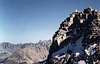
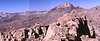
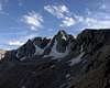
Peak 12,804' - which I have privately dubbed "Lost Lakes Peak" - sits atop the ridge dividing the Piute Lake basin and the Lost Lakes basin near Piute Pass. The peak is composed of dark granitic rock, and has an excellent view of Mount Humphreys, the Humphreys Basin, and it's neighbor, Muriel Peak. The summit straddles the Fresno-Inyo county line. Though this is a lesser peak with no summit register, the climbing is varied and interesting, and can be done easily as a day hike from the Piute Pass trailhead.
Getting There
From Highway US-395 in Bishop, drive up Highway CA-168 to the North Lake turn-off, just before Lake Sabrina. Park in the hiker parking area, about 1/2 mile below the campground. Hike through the campground and up the Piute Pass Trail to the summit of Piute Pass. Hike southeast, following the Fresno-Inyo county line up to a bench below the peak's north ridge.
Red Tape
For day hikes, no permit required. For overnight stays, obtain a free wilderness permit at the White Mountain Ranger Station, 798 North Main Street, Bishop, CA 93514, phone number is 760-873-2500.
When To Climb
Best season is early June to mid October. Earlier than June, use skis or snowshoes to approach. November to January may have some snow, but not enough to ski.
Camping
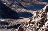
Best camping is at Piute Lake, before Piute Pass, or at Muriel Lake, just southwest of the pass. Fair but exposed camping can be found on the bench below the north ridge, near the Fresno-Inyo county line, or at the Lost Lakes.
External Links

 7977 Hits
 81.5% Score
 14 Votes