

|
|
Mountain/Rock |
|---|---|
|
|
36.57860°N / 118.293°W |
|
|
14505 ft / 4421 m |
|
|
Overview
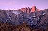
Mount Whitney, of the California Sierra Nevada, holds numerous distinctions. It is the highpoint of both Tulare & Inyo counties. It is the highest peak in the Sierra, & indeed in all of California. Finally, it rises higher than any piece of land in the United States outside of Alaska.
Mount Whitney's elevation stature continues to intrigue the human psyche, both from a civilian as well as a governmental perspective. Its elevation seems to be continually evaluated and reevaluated using the newest technologies, perpetually changing (usually in an upward trend) the mountain's height. The NPS plaque on the mountain lists Whitney's official height at 14,496.811 feet. The most recent observations by NGS (National Geodetic Survey)/NOAA (National Oceanographic & Atmospheric Administration) put it at 14,505' (4,421m)- thanks Eleutheros!
All this being said, it is still no 5,000m (let alone 6,000 or 7,000m) peak. It would be a minor (if somewhat steep on certain aspects) foothill in any of the Earth’s great ranges. It harbors no glaciers. A huge number of people, possessing little wilderness skills or technical expertise, manage to run, hike, &/or crawl their way to the top of this large piece of exposed granite each year via the uninspiring Mt. Whitney trail.
The attributes which make Mt. Whitney a truly great mountain are frequently overlooked. History, commanding position, excellent rock, its great east face & ‘subsidiary’ needles, & a tantalizing selection of routes are arguably the bread & butter of Mt. Whitney. During the winter months, delightful opportunities also exist for the ski mountaineer / backcountry snowboarder.
While its gentle western slopes would hardly inspire the hardened mountaineer, Whitney’s east face, erupting 2,000 ft. above cold & serene Iceberg Lake, draws the climber’s eye upward & makes them yearn. Whitney’s subsidiary needles, (to the south of the main east face), are awe-inspiring enough by themselves, & have their own epics, legends, & lore firmly established.
The proximity of the highest point in the continental US with the lowest point in North America has not escaped notice. The Badwater Ultramarathon, begun officially in 1987, takes some of the most masochistic individuals imaginable from Badwater (Death Valley) to the lofty summit of Mt. Whitney. Before this was ‘en vogue,’ Stan Rodefer and Jim Burnworth of San Diego became the first people to do the Badwater/Whitney (Lowest/Highest) hike in recorded history, in October 1969. They took 2 weeks, crossed the dreaded salt flats and hiked a direct route not using roads or any other conveniences (this was documented by the Park Rangers and in a November 4, 1969 San Diego Tribune article entitled "Hikers View High, Low Sites in the U.S.”). Props. Ouch.
The 11-mile Mount Whitney Trail (class 1) is the easiest and most popular route to the summit and is often done as a strenuous 22-mile day hike. During the summer and autumn months, only sneakers are necessary to ascend this summit from the Whitney Portal trailhead at 8,365 feet, however, earlier in the season, an ice axe and crampons may be required. Many people will appreciate taking two days to do this hike, spending a night at Outpost Camp or Trail Camp. An interesting time to visit is the month of April, before the quota season starts, when the snowpack is firmer and Trail Camp becomes a base camp for groups hanging out in the winter alpine scenery using their 2-way radios to talk to those above Trail Crest.
While there are many other routes on Whitney, the most popular ones after the main trail include: the Mountaineer's Route, East Face, East Buttress, and North Slope. The first three of these start from Iceberg Lake while the last one is often climbed as a traverse from Mount Russell. Winter makes the Mountaineer's Route a popular objective. The East Face & East Buttress are the classic technical climbs on the peak.
For a discussion on winter climbing, see the "When To Climb, Ski, etc." section below.
|
|||||||||||||||||||||||||||||||||||||||||||||||||||||||||||||||||||||||||||||||||||||||||||||||||||||||||||||||||||
|
 |
 |
 |
 |
 |
Getting There
WHITNEY PORTAL: This is the trailhead for both the Mount Whitney Trail and the Mountaineer's Route as well as many other mountaineering and climbing routes on Mount Whitney, Mount Russell, and Mount Carillon. Take US-395 to Lone Pine and then turn west on Whitney Portal Road. In 13 miles, you will reach Whitney Portal at an elevation of 8,365 feet. Bears have been known to frequent this trailhead so do not leave food in your car during bear season - there's a reason why all the garbage cans are bear-proofed. During winter, the last 6 miles of this road are not plowed.
ONION VALLEY: This is primarily a backpacking approach using the Onion Valley traihead reaching Trail Crest in 36.1 miles. The first 7.4 miles cross Kearsarge Pass on the Sierra Crest and bring you to the John Muir Trail (JMT) / Pacific Crest Trail (PCT) where you head south crossing Forester Pass (13180') en route to Mount Whitney via the JMT. You can also bypass Trail Crest on your ascent climbing Mount Whitney's western slopes with a possible camp at Arctic Lake. From norbertc: "Advantages: no crowds, gorgeous scenery along the John Muir trail; no problem getting a last-minute trail permit at Whitney Portal; this is a circuit loop, so when you descend Whitney on the west face you are on that trail for the first time" if you bypass Trail Crest on the ascent. To reach Onion Valley, turn west on US-395 at Independence, north of Lone Pine.
OTHER APPROACHS: In addition to Onion Valley, there are numerous other approaches including Horseshow Meadows typically used for Mount Langley (Ref: gordonye). While these other approaches are interesting for backpackers, climbers will usually be interested in a more direct approach. While one may be tempted to bypass the trail quota when using a trailhead other than Whitney Portal, the Whitney Zone covers a large amount of land to the west of Mount Whitney as well, so although this area may not be patrolled by rangers as rigorously, a permit is still required.
 |
 |
 |
 |
 |
Red Tape
Permits are required year-round, however, a quota is in place for the Mount Whitney Zone from May 1 to November 1 depending whether you are on the Mount Whitney Trail or others, e.g. the Mountaineer's Route (differences described below). Permit information is available on the Inyo National Forest page. Reservations also available at recreation.gov. During other times, a self-issued wilderness permit is required. As of 2022, walk-up permits are no longer issued. You can also check the Whitney Portal Store Message Board for people who have extra openings on their permits.
MOUNT WHITNEY TRAIL: Between May 1 and November 1, there is a quota of 60 overnight hikers and 100 day hikers in effect. 100% of these permits are made available via advanced reservations made during February of the same year (reservations accepted by mail or fax), however permit processing does not begin until February 15. These get taken quickly for weekends and overnights, however, weekday quotas often are not filled. For open slots, permit requests can be made after May 1 (reservations accepted by mail, fax, or phone). Reservations cost $15/person. There is now also an explicit "Trail Crest" Exit permit/quota for people who just use the Whitney Trail as a descent route, say for the Mountaineers Route. Luckily for those of us who don't want to bother with quotas, travel between November 2 and April 30 requires only a self-issued wilderness permit. Let's hope it stays that way.
OTHER MOUNT WHITNEY ZONE TRAILS (INCL. MOUNTAINEER'S ROUTE): All other trails in the Mount Whitney Zone are also subject to overnight and day quotas between May 1 and November 1, however, only 60% are available via advanced registration with 40% reserved for walk-ins. For the North Fork of Lone Pine Creek (aka Mountaineer's Route), only 10 permits per day are currently available, 6 reservable, and 4 for walk-ins). Use self-issued permits at other times.
 |
 |
 |
 |
 |
When To Climb, Ski, etc.
Mount Whitney is a year-round mountain. Between late May and October, hiking/running the Mount Whitney Trail and climbing on the Mountaineer's Route are popular. Then activity generally slackens during the next few months while the snow pack accumulates until the February to early May season when ski mountaineering, backcountry snowboarding, and general mountaineering on routes such as the Mountaineer's Route and the North Face are popular. Mountaineering on the Mount Whitney Trail is also very popular but generally there is not enough good snow above Trail Crest to make this worthy for skiing or boarding.
WINTER CONSIDERATIONS
While winters in the Sierra are relatively mild, compared to say New Hampshire's Mount Washington and Presidential Range, there are some things to consider:
- Climbing Gear: Generally snowshoes, crampons, and an mountaineering axe are required. Expect to use snowshoes on the lower portions of the trail through March/April as you may encounter several feet of fresh snow along the trail, however they may no longer be necessary by late April to May. On the Whitney Trail expect to change over to crampons and axe by the time you hit Trail Crest and above though windpacked snow should begin just above Bighorn Park (outside of the trees). On the Mountaineers Route, you will need an axe and crampons above the notch. Often times rope is used on the last section of the Mountaineers Route to gain the Whitney Plateau.
- Sleeping Gear (Mostly Ref: Gonekuku): Given the Sierra's generally mild weather, you should be fine preparing for a -20°F night though some people go as light as 0°F. Night temps at 12,000' can range from 5°F to -10°F. It's useful to use the "aviation rule" for temperatures: "You lose about 3.6°F per 1,000 feet gained. If it's 40°F low at Lone Pine, it's about 36°F colder on the summit of Whitney that night. (about 7°F at trail camp)." Day temps at Outpost Camp have been reported in the 8-9°F range.
- Approach: During heavy snow, the Whitney Portal Road is closed at either at the Lone Pine Campground (5,900') or the base of the mountain (6,600'). There is no plowing beyond 6,600' and people often park on the north side of the road here. If you take a 4WD vehicle past the plowed area, be aware that your vehicle can get stuck in snow storms or rock slides. During the winter, many groups make their first camp at Whitney Portal (8,365').
- Avalanche Conditions: While the Whitney Trail does not have any recent history of avalanche danger, you should still check the CSAC Avalanche Bulletin (under Mountain Conditions section).
 |
 |
 |
 |
 |
Camping
MOUNT WHITNEY TRAIL: The two popular campgrounds on this trail are Outpost Camp at 10,335' and Trail Camp at 12,000' at 3.8 and 6.2 miles from the trailhead respectively. Those feeling the effects of the altitude will want to stay at Outpost Camp, however, most people making a multi-day trip stay at Trail Camp. During "bear season," you should be prepared for both bears and marmots. In recent years, bears have been known to make it up to Trail Camp so bear-resistant food containers are now required for overnight trips along the Mount Whitney Trail between May 25 and October 31. If you do not have a bear-canister, rangers will ask you to "leave the area." As for marmots, you may want to keep your tent pinned down with rocks and leave it open along with your pack so they won't feel compelled to chew through your gear to satisfy their curiosity.
NORTH FORK OF LONE PINE CREEK: The popular campgrounds along this route are: Lower Boy Scout Lake (10,300'), Upper Boy Scout Lake (11,350'), and Iceberg Lake (12,600'). Many parties climbing the Mountaineer's Route and other East Face routes in 2+ days will try to reach Iceberg Lake on the first day. All camping should be at least 100 feet from the lakes. Human waste should be buried 6-8 inches deep and at least 200 feet (70 paces) from any campsite and water source. Toilet paper should be packed out. According to the Inyo NF, "Improper disposal of human waste at Iceberg Lake is a serious problem." Proper water treatment is probably a good idea here!
 |
 |
 |
 |
 |
 |
Mountain Conditions
Use the following resources to check route and weather conditions on Mount Whitney:
www.395.com - High Sierra Weather Report incl. satellite photo.
Weather Underground - Lonepine, CA Weather Forecast
Whitney Portal Store message board
CSAC Eastern Sierra Avalanche Bulletin
MOUNT WHITNEY RANGER STATION
P.O. Box 8 Lone Pine, CA 93545
(760) 876-6200
(760) 876-6201 TDD
website
Open 7 days/week; 8.00 - 17.00 Nov - Apr, 8.00 - 18.00 May - Oct
At the 'Interagency Visitor Center' 1 mi S of Lone Pine, US 395-State route 136 junction
 |
 |
 |
 |
 |
Whitney, The Man
Charley Begole, Johnny Lucas & Al Johnson took a trip to the summit of the highest mountain in the range, & christened it ‘Fisherman’s Peak.’ Ain’t it as romantic as ‘Whitney?’ The fishermen who found it looked mighty romantic on their return to Soda Springs. Wonder who that old earthquake sharp thinks is running this country, anyhow?
-Inyo Independent, 20 September, 1873
For years our chief, Professor Whitney has made brave campaigns into the unknown realm of Nature. Against low prejudice & dull indifference he has led the survey of California onward to success. There stand for him two monuments, - one a great report made by his own hand; another the loftiest peak in the Union, begun for him in the planet’s youth & sculptured of enduring granite by the slow hand of Time.
-Clarence King
The appellation of what is now known as Mt. Whitney stands as testimony to the rewards of shameless brown-nosing, before the United States Geological Survey (USGS) introduced naming guidelines designed to prevent such shameless & juvenile acts from occurring.
Despite Clarence King's amusing inability to be the first to scale this great peak (the highest in the contiguous United States, no doubt a large contributor to his desire to be the first ascentionist), his boss happened to be Josiah Whitney (1819-1896). Whitney happened to be chief of the California State Geological survey at the time. As Whitney kept on approving the paperwork funding yet one failed expedition to summit the mountain after another for his obsessed henchman King, King felt compelled to express his gratitude in a meaningful manner. Mt. Whitney thus became Mt. Whitney after King & Richard Cotter dubbed it as such in July, 1864 (fittingly from the top of Mt. Tyndall).
A person of modern times could not be blamed for being curious about how Joshiah Whitney became the state’s head geologist (1864-1874), as well as professor of geology at Harvard (1869-1896). Whitney, despite his academic qualifications, held various misperceptions commonly known today to be falsities. He denied the possibility of any active glaciers remaining in the lower 48 states; ironically enough, King named one of the first documented glaciers that he ‘discovered’ (& California’s largest, on the northern flanks of Mt. Shasta) after Whitney). Whitney was also adamant in his denial of Yosemite Valley’s formation by glacial movement (it was indeed formed by glaciers), a concept proposed by the great naturalist & conservationist John Muir, whom Whitney scornfully referred to as ‘that shepherd.’ Interestingly enough, a subsidiary peak of Mt. Whitney, lying a short distance south of the true summit bears Muir’s name.
Miscellaneous Info
GENERAL INTEREST LINKS:
USDA FS Inyo National Forest official web site
Whitney Portal Store: Provides weekly trail report from June to October among many other useful things.
The Whitneyzone- webcam & online forum. Information for Mt. Whitney hikers, maintained by the Mt. Whitney Hikers Association. Badwater Ultramarathon: Although this 135 mile race officially ends at Whitney Portal due to the permit quota, runners have continued to extend this to the Mount Whitney Summit for a "true finish." Al Arnold, 1977, First Ever Badwater to Mt. Whitney (Summit) Finisher: Marathoner Magazine (predecessor to Runners World), premier issue, Spring 1978.
ADDITIONAL BOOKS (not available from Amazon.com):
"Climbing Mt. Whitney: The Complete Guide for Hiking and Backpacking" by Walt Wheelock and Wynne Benti; Published: Dec 1998; ISBN: 1893343006. Available from BarnesAndNoble.com.
 |
 |
 |
 |
 |
External Links
- C.E.Brennen's account of climbing Mount Whitney
- Information about the Mountaineers Route Permits, camping, and details about the Mountaineers Route.
- Helen Smith's Trip Report
- Google Search for "Mt. Whitney Hike" Leads to many interesting pages
- Whitney Portal Store Lots of useful info, photos and maps.
- Mount Whitney USGS Topographic Map Commercial dealer offers standard quad for $6.95.
- Fun, but bloody long, day-hike on the Whitney Trail
- Trip Report: Whitney Trail, June 2010 by backcountrybliss.net
- Mount Whitney, August 2002
- Mt.Whitney East Face in winter of 1983 Miguel carmona on Fresh Air Traverse, East Face in winter of 1983.
- Mt. Whitney, July 9, 2003 Pictures I did Mt. Whitney as a dayhike with my son on July 9, 2003. We started and ended at Whitney Portal, took 6:45 to go up (including breakfast stop and others) and about 5:0 to go down (also including stops.)
- Google image search for "Whitney Hike" Dozens of great photos.
- Mount Whitney Trip Report
- Whitney/Muir/Wotan's Throne (08/30/2005)
- Mount Whitney in November 05 by Main Trail (Text in German)
brutus of wyde - Jan 3, 2006 2:55 pm - Hasn't voted
Untitled CommentFeel free to link it to the "Overview section" of the Whitney main page.
Brutus
redsplashman23 - Oct 3, 2006 6:06 pm - Voted 10/10
Elevation is now 14,505 feethttp://en.wikipedia.org/wiki/Mount_Whitney http://www.halfaya.org/leo/hiking/Whitney/index.htm (Mount Whitney is apparently 14,505 feet according to the latest measurement (see this Wikipedia article), and the trail is 22 miles out-and-back with a net elevation gain of 6130 feet (but also some descent in the middle, so there is more overall climbing).
bearbnz - Jan 20, 2008 12:17 am - Hasn't voted
More red tapeThe North Fork of Lone Pine Creek now requires a lottery permit. From the INF: Originally Posted By: Inyo National Forest2008 Update: Mt Whitney Zone Day Use Quota applies for all day hikes into the Mt. Whitney Zone. This affects all visitors that will day hike into the Mt. Whitney Zone and includes all trails, cross country travel, including the Mountaineers Route, East Face/ East Buttress and other summits within the Mt Whitney Zone. Day use of North Fork of Lone Pine Creek trail is included in the Mt. Whitney Day Use quota of 100 people each day. Visitors with an overnight permit into the Mt Whitney Zone do not require an additional day permit, the overnight permit is valid.
kenrw - Jul 28, 2012 4:16 pm - Hasn't voted
Red TapeIt is true that there are only 100 day-use permits. Most are reserved in advance. HOWEVER, the reality is that about a third are pushed back into the pool every day. There are a lot of cancellations. After 3pm the day before the permit date, about 30-50 day-use permits are available. Do yourself a favor, don't bother reserving a permit. It will be almost certainly be available the day before you need it. Also, there is no fee for getting a permit the day before it is used as a walk-in permit request. I drove down from Bend, OR, and was not concerned about getting a permit.
AskaRanger - Sep 9, 2012 12:23 pm - Hasn't voted
More red tape 20122012 permit software was moved online to Recreation.gov so a few details have changed for the Mt Whitney Lottery. •No more applications by mail or fax. •Lottery applications are filled out online, from Feb 1 to March 15. •Computerized random selection starts on March 16 •Open slots after the lottery can be reserved online starting April 1. •Recreation.gov applies a $6 per application fee •Inyo’s $15 per person fee only applies if you get a reservation. Here’s the link directly to the lottery page: http://www.recreation.gov/permits/Mt_Whitney/r/wildernessAreaDetails.do?page=detail&contractCode=NRSO&parkId=72201 North Fork of Lone Pine Creek is included in the waste management area, so please update your reference to burying poop to reflect use of wag bags.
Diggler - Sep 10, 2012 9:42 pm - Hasn't voted
Re: More red tape 2012The red tape (r)evolution continues! Thanks for posting.
Diesel - Aug 7, 2013 5:09 pm - Hasn't voted
Mt. Whitney - The Rest Is Dowhill!I did the day hike on 7/31/2013. It took me 4:25 to top and 4:25 back to Portal. I had a permit but nobody seemed to care. I hiked alone and decided early on into my hike not to waste time taking pictures going up. I kept a high tempo and did not really stop until at about 14,000 ft where I got a nose bleed. I stuffed some toilet paper in my nose and continued like a maniac since I did not want to lose time. Coming down it was a different story: I took pictures, looked around but most importantly, all hikers I passed on my way up were coming up puffing and struggling. The rule of the mountain is that who’s coming up gets the right of way, so I had to pull to the side and let everyone pass. A few tips: 1) do not make the mistake, as many do, to attempt to sleep in the car at the Portal for acclimatization and early start. There is so much noise at the Portal during night, one cannot rest. Lot of people told me how tired they were due to noise, bright Moon-light and other factors. Cars are coming and going 24 hours. People drag coolers, laugh, scream and open and close the metal food storage containers all the time. Also, if you are not used to sleeping in the car, you’ll never rest properly for the big hike. 2) There is lot’s of water along the trail. If you don’t like drinking right from the creeks, get a filtration pack. It’s much lighter that carrying all the needed water up and down. I needed 3 bottles of water and 2 of Gatorade for the whole hike. I got hydrated very well the day before and drank a good coffee and Gatorade 01 Prepare before the hike. 3) If you are not used to altitude get a prescription of the altitude pills. They helped me a lot. I live almost sea level: altitude over 11,000ft kills me. With the pills though I did not feel the effects of it. I spelt in a motel in Lone Pine. The drive to the portal was 25 minutes. I woke up at 4:AM, eat and left by 4:30. At 5 to 5:AM I was at the Portal. It was so dark I could not see a thing. I used the time to store everything with scent I did not need for my hike into the metal storage contains. I started the hike at 5:15AM when there was a bit of light, enough to see the trail. I did not want to carry the flashlight with me all day for 15 minutes of darkness. By 5:25AM there was daylight. I did train very good for this hike. Do not take my time as a guide. There are people that hike to the summit much faster but I also run into a guy that was coming down and he said he was hiking for 26 hour nonstop! The guy left at 4:00 AM the previous day, made it to the summit and now he was coming back. It was 6:00 AM and he still had 2.5 miles to go. If you remotely think about hiking Mt. Whitney, please do. It will give you personally a great sense of accomplishment. There is not much you can tell others since they will not understand or care, but to you it will men a lot. You will see what I mean after you’ve done it. Good luck.
scraig - Mar 24, 2014 8:41 pm - Hasn't voted
2014 permit lotteryThe red tape section looks dated. I suspect Inyo tweaks the lottery/permit rules annually. Beware that you can only get one permit by LOTTERY per year. I submitted 4 separate lottery applications for 4 separate trips. Got one date, but the other 3 applications got kicked out despite those dates still having availability. Person I spoke to insists the lottery application states that policy, but I did not see it and there is no way to verify until the 2015 lottery starts. You can get multiple permits per year, first come, first served for remaining space after the lottery.
muzik311 - Mar 26, 2014 10:10 pm - Hasn't voted
Mt Whitney Trip Report March 15-19th 2014Recent trip from March 15-19th up to Mt. Whitney on the Mountaineers Route. Had to park at the base of the mountain (around 6,600 ft). The road was gated and locked at this point. Must walk the road (no snow) up to Whitney Portal. No snow until you cross over Lone Pine Creek. Snow starting around 8,500 ft? Snowshoes were mostly worn to Upper Boy Scout Lake. Fully frozen except one patch in the NE side of lake. From Upper Boy Scout Lake to the gully was soft snow and snowshoes were traded for crampons and trekking poles until Ice Berg Lake. Good snow and conditions from this point to the notch with ice axe and crampons. Good amount of snow up to the summit in the cracks. Rock was ice free. No snow on top of summit. It was very warm, sunny, and clear. With one day of wind gusts. Had the mountain top to ourselves !! Photos by Chris Brinlee (webpage: http://www.chrisbrinleejr.com/ )
orri - Jun 4, 2014 2:39 pm - Voted 10/10
Current ConditionsWhitney Portal Store's message board seems to be the best for the most up to date conditions. http://www.whitneyportalstore.com/whitney-messageBoard.html
molliej - Jul 21, 2015 9:07 am - Voted 10/10
DivineThats one divine place. But too risky for my capabilities.
Panorama Paul - Mar 27, 2018 11:52 am - Hasn't voted
Whitney PanoramaPLANNING TO CLIMB MOUNT WHITNEY? You’ll want to know the names of the other peaks: https://www.summitpost.org/labeled-mount-whitney-panorama/1002719/c-841725 . Download before your trek, go on-line while on top AND/OR buy a 2x3-foot fine print from https://www.panoramapaul.com/ .
Jeff M - Mar 2, 2019 11:16 am - Hasn't voted
Mt. Whitney Portal Store WebsiteTheir site changed to here: http://www.mountwhitneyforum.com/ It's got the best online info and webcams since the folks live and work on the mountain and in Lone Pine year-round.
Diggler - Mar 27, 2019 9:42 pm - Hasn't voted
Re: Mt. Whitney Portal Store WebsiteThanks, Jeff- I will update.
adamschneider - Sep 17, 2022 4:39 pm - Hasn't voted
No walk-up permitsSince 2020, there have been no walk-up permits available; you must reserve on-line. (Ref: https://www.fs.usda.gov/detail/inyo/passes-permits/recreation/?cid=stelprdb5150055)
Diggler - Sep 21, 2022 5:21 pm - Hasn't voted
Re: No walk-up permitsThanks, Adam. Will make appropriate revisions!