A great choice
When I look out my kitchen window, it is Lowe Peak that I see staring back at me. One of those peaks that everyone in the Salt Lake area looks at daily but very few know the name of. Of course, there are many that couldn't tell you that the name of the mountain range on the west side of the valley is the Oquirrh mountain range. One of the impressive things about Lowe Peak is the fact that it is 10589 feet high. I'm hoping to get to about the same elevation on Washington's Glacier Peak (10541) in a week or so. However, Glacier Peak is a whole different ball game.
I've had the pleasure of visiting Flat Top mountain on a couple occasions but it was Lowe Peak that I really had in my crosshairs. When my son in law Jeremy from Washington state contacted me and said he'd like to do a good solid hike, Lowe Peak jumped onto the planning table. I sent him a link to the Summitpost page for Lowe Peak and after he read the description and said yes, it was just a matter of waiting until he got here. He mentioned that he'd never hiked in the Oquirrh area and was very much interested in seeing what that area had to offer. He was pleasantly surprised.
First day of summer arrives
Jeremy and his family made the long drive from Washington and on June 21st, he and I were out the door heading for the little community of Ophir, nestled on the west side of the southern part of the Oquirrh range.
Ophir was sleeping when we drove through it and continued up to the end of the road where we would begin our hike. Immediately after leaving the car and starting on the trail we had to make a water crossing of the stream, being careful to find a place where we could cross without getting our footgear wet.
Little did we know that we would be repeating this process 12 more times in less than a mile. In some places the stream was not very wide and easy to find a place to cross (see picture) and in other places we had to make our way carefully but it all worked to slow us down. Finally the water crossings were done with (next time I'd bring sandals for this part) and we were at a meadow area that is 1.3 miles in but it took us an hour thanks to the water crossings.
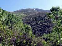
![From near the meadow]() West side of Lowe Pk
West side of Lowe Pk
We stopped for a mini break at the meadow and then continued up the trail until we could see a drainage that looked like we could have easier access by going up it. This saved us dealing with the brush and for the most part it worked pretty well for over a thousand feet of elevation, helping us go from the 8000 foot mark to the 9000 foot level. Finally we decided to get out of the drainage and in checking our GPS and map, realized that we still had 1600 feet to go but we would do that in a short half mile. It was steep but good footing all the way to the ridgeline where we were able to then make our way over to the summit area. Most of the snow was gone and just a few patches remained on the ridge crest but we had no need to use the snow and soon we were thrilled to the views that we had in all directions.
![Up the drainage]() Up the drainage
Up the drainage![Out of the drainage]() Out of the drainage
Out of the drainage
An old antenna structure lay on the ground near the summit and just down the ridge to the north was a small shed like structure (containing some old used batteries) and two antennas that may not be functional any more. A USGS benchmark adorned the summit and a glass register bottle was tucked away in nearby cairn. My GPS said that we had covered 3.3 miles but most of the elevation gain was contained in the past two miles where we gained the lion share of it as we ascended the drainage on the west face.
I could see my house from the summit (just kidding) but I could see where Lehi was located. To the north I could see Tooele and to the east, some of the Salt Lake City area. The nearby mountains were beautiful with Flat Top to the south and many others that I didn't know the names of. After a short lunch break and a cell phone call or two, we headed back down only with the intent to go over towards Dead Ox pass and make our way back down a prominent ridgeline that looked like the best way to get back to the meadow.
Summit time
![Flat Top]() The view south
The view south
![At the summit]() The summit The summit | ![The top]() On top On top | ![Summit cairn and register]() Summit cairn Summit cairn |
The reception committee
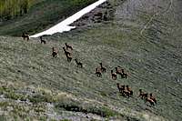
![Elk on Dead Ox Pass]() Elk at the pass
Elk at the pass
As we headed down, we traversed over toward the ridgeline and the pass and upon getting to a spot where we could see the pass clearly, we noticed a large herd of elk grazing there. Immediately we knew we had a photographic opportunity and since Jeremy has a nice SLR, he was the one to try and get close for some good pics. As he moved closer the elk tolerated him while he was snapping their pictures but it seemed like he crossed an invisible border
and they were suddenly on the move and were heading on over the pass and over the eastern side of the mountain. They are absolutely beautiful animals and we counted about 60 overall. A few of the pics Jeremy was able to get are included with this trip report.
We had dropped over 1300 feet from the summit and to get back up to the ridgeline we had intended to take would require us to reascend some elevation so we decided to just drop straight down from the pass and make our way to the meadow. It turned into a bit more of brush fest than we thought it would be but as always, going downhill through the brush is always easier than going up. Often we could find lines that the elk had created through it and that helped. On the way to the meadow we surprised one deer but that was the extent of the wildlife we saw during out visit. On the way out, instead of finding ways to get across the stream crossings without getting our boots wet, we just walked through them. My boots and socks were thoroughly soaked of course when I reached my vehicle but I really didn't care, we had had an extremely satisfying day for the first day of summer.
![Oh no, they re running away]() Stampede
Stampede
Totals: 7 miles Elev. gain 3500'
More pictures
More elk pictures by Jeremy
Our route


Comments
Post a Comment