


lsheen - Jun 18, 2012 7:10 pm - Voted 10/10
Khumbila...Or Khumbu Yui Lha in the background?
Big Lew

Marcsoltan - Jun 18, 2012 7:13 pm - Voted 10/10
Re: Khumbila...Lew, I spent several days waiting for a plane in Lukla. I don't remember any mountains like this anywhere near Lukla.

Nigel Lewis - Jun 19, 2012 9:19 am - Hasn't voted
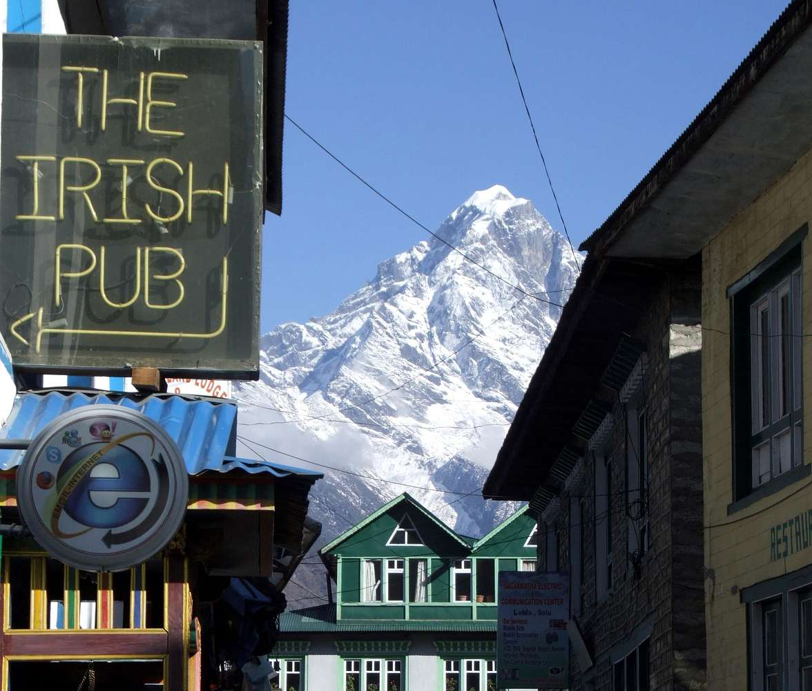
Re: Khumbila...Well I can assure you I was standing near to the Starbucks coffee shop on the main path from the airstrip toward Namche bazzar when I took this picture. All I can say is, either you weren't looking properly or it was cloudy!!
Marcsoltan - Jun 19, 2012 10:01 am - Voted 10/10
Re: Khumbila...I remember another airstrip at Kumjung (sp?), or Chukung (?), just above Namche Bazzar. That was in the mid 90s. Lukla was about a 4 hour walk down Khumbu valley from Namche. You could NOT see Namche from Lukla. Now, I wonder if they expanded the airstrip above Namche, and called it Lukla, or Lukla High! I spent 4 days at Lukla, the old location, no beautiful mountains anywhere to be seen, no clouds, only green hills and carcasses of crashed planes to keep people entertained, a boring place. But yes, Namche Bazzar is surrounded by beautiful mountains.
I walked from Jiri to Leboche, a distance of 120 miles, to climb the Leboche peak. On the way back, I was tired and decided to fly out of Lukla. But, since I didn't have reservation, I had to wait a few days. It got cloudy for a few hours every day, but it would be sunny most of the day. I think things have changed, Starbucks, Irish Pub....
Nigel Lewis - Jun 19, 2012 2:00 pm - Hasn't voted
Re: Khumbila...This picture was taken at LUKLA!! Not new Lukla, not Lukla high, but LUKLA. You're right about one thing, though. You can't see Namche from Lukla. But then I didn't say you could. The photo is taken on the main street that runs at a 90 degree angle to the airstrip at LUKLA. The path goes toward Namche baazar and is the main route to Everest base camp. Lukla is indeed several hours walk further North. We got back to LUKLA a few days early and had to wait for a flight as they were all booked. We spent several days in LUKLA and I am quite familiar with the place now.
The Zatrwa pass is a half day walk from LUKLA and is covered in snow. It's a very common route to the Hinku valley. There are F*cking big mountains the other side of the valley that are covered n snow, and the mountain in this picture, which I took from the street in LUKLA is covered in snow.
I am not mistaken. I was in LUKLA when I took this picture, and they sure as damn it haven't built the mountain since you were there. The bars, coffee shops and internet cafes make it more bearable though!
N
Marcsoltan - Jun 19, 2012 2:16 pm - Voted 10/10
Re: Khumbila...Okay, there is only one Lukla, and it's the one we both have been to. I know now what gave me trouble with this picture. When I was there, there wasn't a spec of snow on the ground. Mountains look quite different with snow on them. The mountains around Lukla looked so boring, at that time, I didn't even take any photos. All I remembered were green hills. My apologies.
Marc
Nigel Lewis - Jun 19, 2012 2:24 pm - Hasn't voted
Re: Khumbila...Thanks Marc, it's appreciated!
N
lsheen - Jun 20, 2012 6:52 pm - Voted 10/10
Glad we sorted THAT out!;^)
Still wondering if it is in fact Khumbila in Nigel's photo... I'm about 95% certain it is but...
Big Lew
Marcsoltan - Jun 26, 2012 4:20 pm - Voted 10/10
Re: Glad we sorted THAT out!Hey Lew, since Nigel hasn't seen your latest comment, I am taking liberty, with Nigel's permission, to answer your question. I clicked on the link you provided on your first comment. One of the photos shows several monks outside of Tengboche Monastery with Khumbila in the background. The village of Tengboch is pretty far from here and impossible to view from Lukla. In fact, it's even further than Namche Bazar which cannot be seen from here. So, I am sure Nigel will agree that this mountain is not Khumbila.
Marc
Nigel Lewis - Jun 26, 2012 10:54 pm - Hasn't voted
No mapsorry guys, I don't have a map of the area and I can't remember whether I was looking North or South when I took the shot.
N

Nelson - Jun 27, 2012 1:02 am - Voted 10/10
Re: No mapNice shot. I think it's Kwangde Ri, also called Kongde Ri. It is at the eastern end of the Lumding Himal, northwest of Lula and southwest of Namche. At least that's a guess from looking at my map.
Marcsoltan - Jun 29, 2012 1:44 pm - Voted 10/10
Re: No mapWell, you may be right Lew. Here's more wood for the fire. Click on the link and see my question to William Marler and his answer.
Name the mountain
lsheen - Jun 30, 2012 12:02 am - Voted 10/10
Re: No mapHi Marc,
I appreciate your comments, and I appreciate your help. I would LOVE to confirm once and for all the name of this peak! And... I understand this may not be possible.
Mr. William Marler (one of my SP heroes, BTW) says this peak didn't have a well-known name in '86, although he sort of implied that it might soon get one.
In the course of my research, I found a bunch of more recent pics via Google (image search for Nupla) that identified this peak as Nupla. I have also checked several online and digital maps (particularly Google Earth), and mostly found agreement. Perhaps Nupla was the name that was under consideration when William took that pic, and is the eventual and current name of this beautiful peak - looking north up the Main Street in Lukla?
Marc, over the years I have learned that ID'ing any Himalayan peak is a daunting challenge... it seems that there are conflicting names and elevations for EVERYTHING!
Peace,
Big Lew
lsheen - Jul 1, 2012 6:44 pm - Voted 10/10
Re: No mapBTW Nelson - I think you are absolutely one of the best photographers here on SP, and I certainly didn't mean to come off as combative or disrespectful. I looked at maps also, but Google Earth was what convinced me that this peak is Nupla.
I'm honored you chimed in on this thread, and I wish I didn't have to respectfully disagree with you about the ID of this peak!
;^)
Peace,
Big Lew
Nelson - Jul 2, 2012 9:46 am - Voted 10/10
Re: No mapBig Lew,
Thanks much for the complement. Hardly-deserved, as there are so many outstanding photographers on this site. But much appreciated.
I just looked at your annotated photos and humbly defer to you in any Himalayan peak naming discussion!
To try to pin this one down I had pulled out my copy of the 1987 Schneider Shorong / Hinku map and tried to determine which peak it was. Nupla was what I had settled on, but then I found this and fell into the trap of believing something on the Internet at face value.
http://www.art.com/products/p14430213-sa-i3028611/tom-cockrem-mount-kongde-ri-towers-over-lukla-village.htm
Thanks much for your correction and I'm glad the mystery is solved. I look forward to seeing some more of your annotations. They are fantastic!
- Nelson


Comments
Post a Comment