
-
 56398 Hits
-
 74.92% Score
-
 5 Votes
|
|
Route |
|---|---|
|
|
38.02213°N / 119.23462°W |
|
|
Hiking, Scrambling |
|
|
Summer, Fall |
|
|
Overview
 Lundy Canyon
The 3.0 mile long Lundy Canyon Trail packs an amazing amount of spectacular scenery into a short, intense trip into the heart of the High Sierra’s Hoover Wilderness. Along the way, one encounters historic ruins, enormous beaver ponds, beautiful waterfalls, abundant meadows and wildflowers, soaring cliffs and ultimately the beautiful granite playground of the Twenty Lakes Basin. However, to earn the Lakes Basin, one must climb a potentially treacherous trail the leads up a talus-filled chute that is precariously steep and unstable. The trip up is nonetheless exhilarating, providing stunning vistas and an intimate view of one of the canyons tallest and most beautiful cataracts.
Route Description
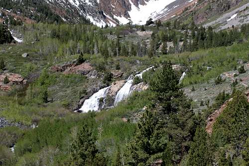 The lower falls in Lundy Canyon
The Lundy Canyon trailhead is found alongside Mill Creek, in a large grove of aspen. Watch for felled trees and conical stumps left by the beavers. The trail itself is found in the northwest corner and passes through the aspen grove for a few tenths of a mile. Soon the trail climbs out of the aspens and rises high above one of the large beaver ponds. Terraces at the upper end of the pond show how industrious the beavers are. The extreme end of the pond is pummeled by the lower Lundy Canyon Falls. The falls are sixty to seventy feet high and fall in two parallel horsetail plunges. The trail passes near the top of the falls and shortly thereafter, at 0.5 miles from the trailhead, passes the wilderness boundary and officially enters the Hoover Wilderness.
At this point, the trail approaches another, smaller beaver pond. A large cataract flows into Mill Creek from the north. This creek’s source is Burro Lake, found high above the canyon floor in a cirque beneath 11,770 foot Black Mountain. A series of rough use trails depart the Lundy Canyon trail here and parallel the steep cataracts on their east side. After 1,000 feet of climbing the route eventually follows the creek when it turns to the west and climbs another 1,000 feet before reaching the first of a couple of tarns prior to Burro lake. The lake’s perimeter is nearly 0.5 miles around and rests at 10,551 feet. Black Mountain soars another 1,000 feet above. Solitude is practically guaranteed.
 Looking north, up the route that leads to Burro Lake
Continuing west on the Lundy Canyon Trail, the route passes around the small beaver pond where the Burro Lake route departs the main trail. About 0.5 miles from the wilderness boundary, the trail crosses Mill Creek and enters into some of the best wildflower areas in Lundy Canyon. While the trail has been fairly level to this point, the stretch from the crossing to the second falls is the most level. Another 0.5 miles of easy hiking through the wildflowers brings one to the foot of the second set of falls along Mill Creek. The creek drops over a series of falls ranging in height from 20 to 40 feet. While there are numerous cataracts along this stretch, core is a series of four falls that drop in rapid succession, totaling about 100 feet.
Beyond these falls, the trail begins to climb above the creek. The ascent is gradual at first, but it eventually begins climbing more earnestly. Soon the trail begins the first of three sections of tight switchbacks that ascend the walls of Lundy Canyon and lead to the Twenty Lakes Basin. The first switchbacks only climb a few hundred feet before the trail straightens out. Mill Creek can be seen crashing down the canyon below the trail, while views of the end of canyon and its falls are stunning.
 Looking down the chute that climbs out of Lundy Canyon
Soon the trail begins to switchback again, entering into the chute that it will ultimately ascend. A massive waterfall drops parallel to the trail for the duration of the climb up the chute. Caution should be taken when climbing this section of the Lundy Canyon Trail. While the trail is easy to follow in most places, the talus that fills the chute has yet to find its angle of repose and there are sections of trail that have been erased by moving rock. One must respect the miners who established this route in the 19th century. Two stretches of switchback ascend the chute. The first stretch is the most treacherous, since it climbs the talus slope itself. This is the section where portions of trail have been lost. Simply pick one’s way across the rocks and link back up with the established portion of the trail on the far side of the slide areas. The falls parallel to the trail can be heard here, but most of the cataract is not visible. Halfway up the chute, the trail climbs off of the talus and switchbacks its way up the solid rock that flanks the talus slope. Near the beginning of this second stretch of switchbacks a small stone bench marks the point from which the falls first become completely visible, which they remain until one climbs completely out of the canyon.
 Looking towards the Twenty Lakes Basin from the end of the Lundy Canyon Trail
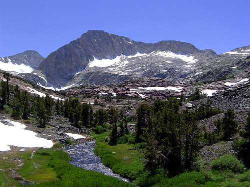
Once the climb out of Lundy Canyon has been completed, the terrain changes suddenly and dramatically. Where the stone composing the canyon was red and gray metamorphic rock, the stone composing the Twenty Lakes Basin is white granite. The sides of the creek are lush, although the basin rests just at the treeline. The massive bulk of North Peak and the glacier clad flanks of Mt. Conness loom majestically above the basin. The trail continues a short distance to the outlet of Lake Helen. Here the trail splits, with various routes leading into the heart of the lakes basin. The route to the left ultimately leads to Saddlebag Lake, while the one leading to the right penetrate into the wilderness, leading to Steelhead Lake, one of the largest in the Twenty Lakes Basin.
Getting There
From Lee Vining drive north on Highway 395 for roughly 7 miles. At a signed intersection turn left onto Lundy Lake Road. The intersection is signed at difficult to miss. Drive west 5 miles to Lundy Lake Resort. The road travels above Lundy Lake, which is an impoundment on Mill Creek. The resort is rustic and offers cabins and campsites. At the resort, the pavement ends and the road continues another 1.5 miles to the trailhead. The dirt road is in good condition and it easy for sedans to reach the trailhead. Numerous parking spots are found off a loop at the trailhead.Map
