
|
|
Route |
|---|---|
|
|
44.99200°N / 111.452°W |
|
|
Hiking, Scrambling, Skiing |
|
|
Spring, Summer, Fall, Winter |
|
|
Most of a day |
|
|
Mostly Moderate |
|
|
Class 4 |
|
|
Overview
 Route
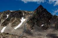
Route South View
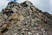 Summit
From the Taylor Fork trailhead to the East summit via the south couloir is right about 10.5 miles, and 3950' of elevation gain. The south couloir route to Imp gives relatively quick access to the East Summit, which is believed to be the higher of the two, but likely by a few feet. The couloir in late summer is steep, loose talus with an assortment of boulder sizes. It runs about 1000-1100 feet vertically. Once you top out on the couloir, the east summit is a short scramble with a couple of route options.
The direct route has a couple moves with some exciting exposure below, but nothing you need to rope up for. At the same time, not a great place to be seriously challenging yourself if you are not experienced or comfortable with moderate scrambling on exposed mountains (go do Beehive first). The second route option is much easier and essentially cuts south around the more intense direct route, and connects a few ledges to the summit.
The summit 'block' affords some greats views of the surrounding areas, both in the immediate Madison range, and surrounding ranges including the Gravelly, Tobacco Roots Gallatin, and Absaroka ranges. Probably the most exhilarating view is towards the south, where Echo and Hilgard prominently cut into the skyline. To the north are the nearly-as-impressive north Taylor peaks including Koch, with several visible lakes. Further in the distance are the outline of the Spanish Peaks, with the monarch Gallatin Peak rising up like a giant pyramid.
On top of the summit, look slightly south for a long boulder bridging a gap with a few hundred feet of air below.
Getting There

All the main accessible routes to Imp are from the Taylor Creek road from 191, being that Wolf Creek on the Ennis side is privately owned. To get to the Taylor Fork trailhead:
About 56 miles south of Bozeman on Highway 191, turn west up Taylor Fork (dirt) road which should have a Forest access sign on the highway. Follow this well used dirt road for a little over seven miles, and then bear left at the fork, following the sign towards Lightning Creek for another two miles.
There is a parking area immediately after crossing over the creek on the left side. This trailhead gets a moderate amount of use, but I think very few people ascend Imp. To access the south main couloir, follow the trail leading to Alp Lake. Start off following Lightning Creek, and stay left at the fork 1/2 mile in. After three miles cross the creek following the sign pointing towards Alp Creek, which will lead to Alp Lake in an additional five miles. From here (Alp Lake), the route should be obvious, cutting across at least half a mile of talus fields to arrive at the bottom of the south main couloir. Many sections of the trail from below Alp Lake disappear in and out, probably from sheer lack of use in this area, so be ready to route-find a bit.
Route Description
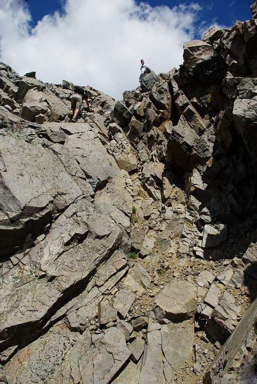 The "Crux Move"...
On the main south couloir, snow will likely linger well into the summer. We did Imp the first day in August, and there were still remnants of snowfields on the south side and much more on the north aspect. The snow may limit your route options, but we kept to the right side of the couloir (east edge) and stayed essentially on the larger boulders that were less likely to start shifting around. And this is not the safest route; there is plenty of potential rockfall danger, helmets would be a great idea at a minimum for protection. I have no idea how the avy danger would be in the winter, I'm sure it would be dependent on the snow conditions, with an angle of roughly 40+ degrees. Practice smart techniques scrambling side by side with your partners to mitigate friendly-fire rockslides on each other.
Essential Gear
 The Talus...
As mentioned previously, a helmet would be a great idea in the couloir. Depending on the time of year, a set of crampons and an ice axe for arresting could be wholly worthwhile packing as well. Additional emergency gear for typical, unpredictable Rockies weather would be wise including (but not limited to) a first aid kid, durable rain shell, high protein snacks, several layers for warmth, map and compass, headlamp and bearspray. I would also recommend either packing at LEAST 3-4 liters of water, or bringing a filter / water treatment system.