![Harrison Peak]() Harrison Peak and Lake. Photo by Vertx
Harrison Peak and Lake. Photo by Vertx
We had no plan. Sometimes that gets people into trouble. Other times just playing it by ear makes for a great trip. My friend Rob and I experienced both on this crisp fall day. We decided to hike into Harrison Lake in the Selkirk Mountains north of Sandpoint Idaho, but hadn’t talked or even thought about doing anything else. We arrived mid-morning after a bone-jarring ride up the Pack River road, which may be one of the worst roads in Idaho and started the monotonous 2.5 mile hike up the trail to the lake. The hike seems much longer than its given length probably because parts of it are on an old road bed through scrubby forest that had been cleared decades ago making for an uninteresting world now. But the arrival at Harrison Lake always makes the trip worthwhile. The large oval lake sits lengthwise in a granite cirque encircles with a large dark slab on the south, sharp arête with pyramidal points from the southwest to northwest and a forested slope on the north that merges into talus and the spectacular horn of Harrison Peak with its overhanging west face in profile.
![Harrison Peak viewed on the...]() Harrison Peak. Photo by Montana Boy
Harrison Peak. Photo by Montana Boy
Generally Harrison Lake would be a crowded place the first weekend of September, but due to the unsettled weather perhaps, no one was in site. For some reason I don’t recall, we didn’t bring our fishing poles as we usually did and when one of us suggested climbing the sharp pyramid on the ridge southwest of the lake we were on our way. I had never really climbed anything before and generally I thought people who climbed mountains were nuts. But it wouldn’t hurt to hike up until it got dicey, and then find something else to do. We scrambled up the steep talus slope and made the ridge in little time. The view west into Two Mouth Creek really grabbed a hold of me as I surveyed the awesome gaping hole in the earth formed by the U-shaped valley 2-3,000 feet deep and miles long. It ran south to north, and then curved west toward Priest Lake dividing contorted and glacially carved lateral ridges. The ridge we were on was remarkable narrow, which we could not discern from below. The point directly west of the lake, which was to our right looked thick from below, but it was a remarkable thin fin only a few feet wide. It seemed like the wind could blow it down. Turning left we headed to the larger horn to the south.
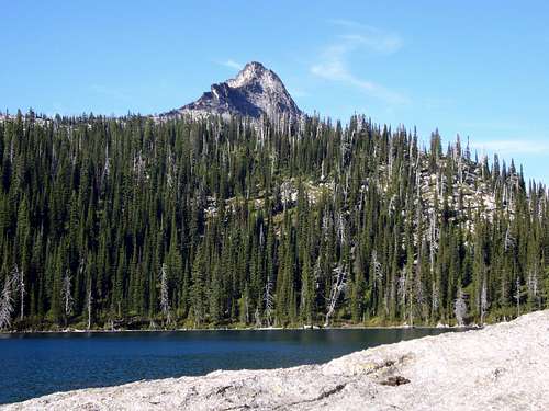
![Still Frozen, June 7, 2003]() The low ridge line beyond the Harrison Lake is where our traverse started. Photo by Cascadeclimber1978.
The low ridge line beyond the Harrison Lake is where our traverse started. Photo by Cascadeclimber1978.
Moving up such a narrow ridge definitely pushed my comfort level. Looking left or right made me dizzy. Having a complete lack of thrill genes, this is not somewhere I would have chosen to be, but we had come this far and were almost to the top. It helped to focus on the rock directly in front of me so my head did not spin, then inch forward. Occasionally the rock became so thin I was compelled to sit down and straddling the ridge crest scoot forward with a thigh hugging either side. Very soon we were on the top enjoying the fabulous view. It was an interesting mix of physical and emotional sensations. On one hand I was exhilarated, but on the other hand my whole being felt unstable on such a small point of rock. To the west the slope was extremely steep and fell for about 2,000 feet. To the lake and open subalpine basin to the south the drop was nearly 1,000 feet, but actually cut back in below us a little. I was most comfortable looking to the south down the crest, which became a little broader; at least enough to where I could walk down it without feeling dizzy. So we chose to head that way instead of returning the way we came.
It seems somewhere I recalled reading in an old hiking book that there was no safe way to head south on the ridge or into the subalpine basin below from Harrison Lake. Pushing that in the back of my mind we continued on marveling at the twisted and contorted subalpine fir that may have been over 100 years old, even though they were only a few feet tall and not larger in diameter than an arm. Soon we came upon a plaque cemented in the ground. What the . . . ! Of all the things and places in the world! Why would anyone pack such a thing up here? Reading it we learned that a small plane had crashed here many years with a family aboard and all had miraculously survived. The plaque was praising God for their survival. There was a chunk of the plane lying nearby, but I imagine the rest was far below somewhere. Hope they made it down all right.
We continued on the ridge to the south finding the going increasingly difficult in the narrowing fractured granite. Looking ahead we could see the ridge eventually became impassable as it ascended the next peak so we would have to find a way off. There didn’t seem to be one at hand, but not wanting to back track we continued forward hoping one would materialize. Nothing really did, but after much scouting around we found the least evil option and started our tentative descent. At first it wasn’t too bad but about 40 feet from the large subalpine bench below the rock became nearly vertical with only a few subtle holds to place our feet or hands. There was no other way down, but this was way beyond our abilities. We worked and worked and in desperation felt things we could not see and did things we thought not possible. Soon going back up was not an option and going down didn’t look much better. But necessity is a good teacher and we pulled off what seemed impossible to us. That was very satisfying, but I don’t recommend this method of learning.
The bench formed a large strip parallel to the ridge and separated from the upper river valley to the east and Harrison Lake to the north by rugged rocks and difficult terrain. Not wanting to negotiate this ground back to the lake and wanting to see new country we continued south toward Little Harrison Lake of the Beehive group. We found this large subalpine bench to be a wonderland. There were meadows and glades with springs broken up by granite mounds and ledges. The water was much appreciated since we were too stupid to bring our own. We found small snow fields that appeared as if they would survive the summer and be relieved by the snows that could come any time. Our favorite area was a giant flat slab of granite perhaps a half acre in size that was crisscrossed by white and glassy dikes of quartz. Soon after this we dropped down into a small rock basin that held Little Harrison Lake.
This lake is very remote and hard to reach, but small campsites about the lake made it obvious that people did come here occasionally. The water was crystal clear and we could see fish cruising the surface looking for food. The huge wall of the cirque on the other side rose up over 1,100 feet of vertical rock broken up only by a few small ledges supporting precarious alpine garden mats. We had a nice break here. Looking back over the ridge and the bench we had traversed we marveled at the slope we had come down. While on it, things seemed nearly vertical, but now it seemed completely so and smooth beyond possibility for us. We marveled then as we do now that we made it down in one piece.
While sitting here we heard a voice call to us. Surprised we looked around until we saw a small figure on the ridge to the south that separated us from the rest of the Beehive Lakes. Someone up there was calling asking where we had come from. We called back communicating our route and that was the end of the conversation. Perhaps it was the long distance and he was satisfied; perhaps he thought we were nuts and just sat there. But the day was getting old so we had to move. There only seemed to be one way down from here and that was down the outlet of Little Harrison Lake, which should put us down near the source of the Pack River and the trailhead.
![Summit View]() The last part of the hike went from Little Harrison Lake (cirque below peak on left margin) down the slope to the left to the trailhead in the valley bottom. Harrison Lake is at lower right. Photo by Cascadeclimber1978.
The last part of the hike went from Little Harrison Lake (cirque below peak on left margin) down the slope to the left to the trailhead in the valley bottom. Harrison Lake is at lower right. Photo by Cascadeclimber1978.
The brush was horrendous, but we did find what must have been some of the most spectacular huckleberries on the planet. This was well appreciated since we didn’t bring along any food, not planning on being gone so long. Soon we came to the perch, an abrupt drop off into the main canyon below. There are three main waterfalls that could be seen from the trailhead and we had arrived at the first one. These are not exactly waterfalls, but rather giant water slides down huge open faces of granite of 80-90% slope that drop a few hundred feet each. Fortunately they were dry except near the stream so we could carefully pick our way down next to the bouncing white spray of water. At the bottom the world was blasted with giant rocks and splintered tree cast about. During the spring run off this was probably quite an awesome site. We repeated this twice more and soon found ourselves at the bottom of the main canyon. We only had to struggle thorough dense brush for a short time and ascend a relatively gentle slope before we found the road and soon the trailhead. We hurried back to Sandpoint as fast as we cold on the goat trail and got us some subs.
It would appear we had survived the day. The trip was totally spontaneous and no one knew where we were. We did not know ourselves where we would be from one hour to the next in this difficult and beautiful country. Looking back over the years, this day found me stuck to probably the only technical rock I ever have been on. Though I’ve been close a time or two and in tight situations, nothing compared to this. Somehow I survived my stupid youth.


Comments
Post a Comment