
-
 3225 Hits
-
 76.66% Score
-
 7 Votes
|
|
Route |
|---|---|
|
|
46.48785°N / 12.70727°E |
|
|
Hiking |
|
|
Spring, Summer, Fall |
|
|
Half a day |
|
|
Hike |
|
|
Overview
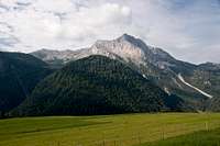
 Malga Pieltinis as seen from Forca Pieltinis Malga Pieltinis as seen from Forca Pieltinis |
The eastern route up to Monte Pieltinis starts in the south-west of the mountain and circles it to reach it via its east face. Most of the route is hidden underneath the canopy of a larch forest and only the last third rans along in the open. There you traverse a big pasture, Malga Pieltinis, which in spring and early autumn is a wonderful bed of wildflowers. However, Torrente Pieltinis, the creek, which springs on the pasture can turn it into a swamp after rainfall. Make sure you are equipped to wade through the bog.
Much of the route runs along roads: the first third is a forest road between Sauris di Sopra and Sauris di Sotto and on Malga Pieltinis you will make use of the support road for the local farmstead, Casera Pieltinis. From Forcella Pieltinis (don't blame me for the lack of inventiveness of the local names!), the saddle between Monte Torondon and Monte Pieltinis you follow a narrow mountain track along the east ridge of the mountain.
Getting There
There is a small parking lot at the western end of Sauris di Sopra. How to get there is described in the Monte Pieltinis main page.Route Description
 Route Profile Monte Pieltinis
- Start altitude: 1350m
- Summit altitude: 2027m
- Prevailing exposure: North close to the summit, no exposure before
- Type: Hike
- Protection: none
From the parking lot at the western end of Sauris di Sopra head into the village. In the village centre the route across Sella Festons turns off to the left. Remain on the main road and leave the village at its eastern end. After a left and a right turn, right before the road starts to drop towards Sauris di Sotto, a forest road turns off to the left.
 |  |  |
Passing a few houses and huts the forest road finally plunges among the trees. At first it climbs rather steeply but later it drops again, losing all the elevation, that was gained previously. At km 3 a the road turns right in a sharp turn and here a narrow mountain path turns off (keeping the previous direction, signpost!). Now a steep section of roughly 2km takes you to a sadlle between Monte Hoche Lanar and Monte Rinder Perk.
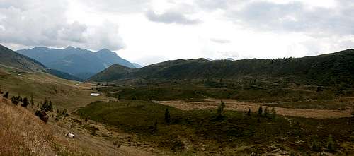
 Malga Pieltinis underneath Monte Pieltinis, Monte Torondon and Monte Novarza
From this saddle you can look across Malga Pieltinis with Monte Pieltinis, Monte Torondon and Monte Novarza as backdrop. Descend into the bowl of Malga Pieltinis. In its centre you need to cross Torrente Pieltinis, a creek which spring in this pasture. As mentioned before, in rainy periods the creek can turn the lower parts of the meadows into a swamp. Pass to the other side in the direction of the plainly visible farmstead Casera Pieltinis. You will reach the support road for the farm some 500m to the west of the farm buildings.
 Looking towards Col Gentile from Malga Pieltinis
Turn westward onto the support road, which heads directly in the direction of Monte Pieltinis. Two switchbacks take you to the saddle of Forca Pieltinis, from where you get the first good views of the Terze - Siera Group of the southern Carnic Alps to the north.
Leave the road on a rocky mountain path, which scrambles up to the east ridge of Monte Pieltinis. The path follows the east ridge for a while before passing the summit and heading for a spot on the south ridge. Here the western route joins and together they climb the grassy south ridge to the summit.