Foreword
I made a wonderful trip in the neighbouring Montasio/Fuart group previous year. As I couldn't fight the desire of returning to the area, I tried to find companions for a next visit.
Our little group consisted of four persons: Anikó, Feri, Kati and me.
The plan
The original plan was that we ascend from the lakes of Fusine on the Via della Vita, and settle down in Bivacco Tarvisio for the next two days. The second day is for Mangart, and the third is for the descent via the Ponza chain.
First day
We arrived to "Seven Dwarves Inn" (Ai Sette Nani) at the upper lake of Fusine just a few minutes after noon. After packing the rucksacks and having a few suspicious glances to the clouds appearing on the sky, we departed.
We took the path no. 513. The first half an hour was easy walk in a forest of pines. Later it became a steep trail but still in the forest, until we reached the meadows of Alpe Vecchia. We had a rest here, and looked to the sky again and again as the clouds coming through the ridge looked more and more dark although the sun was still shining.
As we continued our way, the rain began to fall. I asked the others' opinion about changing the plan and going to bivacco Nogara instead of risking the hart ferrata of Via della Vita, but they weren't so worried about the weather and finally we proceeded on the original route. The rain also stopped later, so it proved to be the right choice.
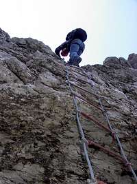
The ascent to the start of the ferrata however, wasn't as quick as the first walk in the forests of Fusine. It was four o'clock when we reached it. We had another pause, take our harnesses and VF equipment, and some chocolate and raisins also:)
Probably the hardest point was the first few meters of cable in a chimney, with a steepness of more than 90 degrees. We had quite heavy rucksacks and they appeared to pull us back to the ground. Finally we managed to pass this point.
The following stage was a system of grassy ledges with some climbing between them. This was quite easy, and soon we arrived to the most interesting part: a tall, vertical wall. As there were a large group coming down, we had to wait a little (there wasn't any place in the wall to pass them by)
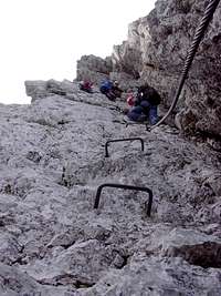
At the foot of the wall the end of the cable was swinging loosely, and later we figured out that it is not so bad as it seemed to be as we needed to traverse a few meters horizontally to find grips and steps. Here the cable was combined with chains and we used the latter to click the carabiners in, as there was no use of clicking into the unmounted cable.
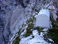
![Bivacco CAI Tarvisio]()
After this wall, which appeared to be the key point of the ferrata, we arrived to a wider ledge with several marks in different directions. I examined the map, and decided that we must be at the point where the path towards Veunza deviates to the left, so we have to turn right. I was wrong, of course. We followed the marks and it meant several minutes of scrambling (UIAA II/III). Finally we reached another, well marked horizontal path, and an arrow in the direction we were coming up, with the label "NO!!!". It must have been the old trace of the path, and later we named it "no way" after this label. From here there were no major difficulties until we reached the bivouac at 7:00 PM.
We cooked some soup and fell to the beds, exhausted.
Second day
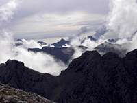
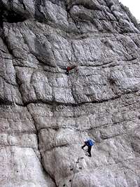
We woke up in the morning to a magnificent view of summits and puffy clouds paced together. After having some breakfast we started to climb on the ridge towards Mangart. The path was a mixture of well-secured, but hard via ferrata and easy but unsecured scrambling of grade I-II. The first summit was the Piccolo Mangart di Coritenza / Mali Koritniski Mangart. After the summit the trail became an easy path winding between the rocks of the ridge. Sometimes it went directly on the ridge but mostly on the Slovenian side (as the other side is perfectly vertical). Later there were secured parts again, but it remained an easy path. However, it took a long time to reach the saddle of Mala Forca /Huda Skrbina.
![Near Mala Forca / Huda Skrbina]()
Here the path deviated from the ridge and crossed the steep meadows of the Slovenian side until it reached the saddle before the Mangart itself. We examined the map in this saddle and decided to ascent to the summit on the normal way, then to descend on the Slovenian ferrata and to come back on the northern side to this point.
We reached the summit around noon. Unfortunately the surrounding mountains were partly cloudy and soon the peak itself was surrounded by fog. We made a few pictures, had a small lunch and started to descend.
The Slovenian ferrata of Mangart is quite easy, some people didn't even use any security equipment. The return path on the other side was simple, too, but as we returned to the saddle east of the summit, the rain began to spit again, and distant thunders were echoing between the mountains.
We hurried back to Mala Forca (if we can call it hurrying as it wasn't really fast:) and took the track passing Mali Koritniski Mangart from th south instead of getting strucked by a lightning on th ridge. The thunders were drawing nearer, and the rain did not stop. The map showed a fork where one of the paths is going down to Koritnica valley and another back to the ridge. When we thought we reached this point we deviated to the left by a small path on a grassy ledge. Later it became narrower and narrower and finally it disappeard.
We didn't want to go back as the hut was already visible and behind us the storm was approaching, so we continued to traverse on the grassy-rocky slope until we reached the ridge again, just in a hundred meters distance from the bivouac.
Third day
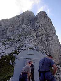
We were still tired after next morning, so the plan was modified. Instead of walking along the long Ponza chain we decided to go back on the Via della Vita to the valley. But before going down we visited the Veunza, leaving our rucksacks near the place where Via della Vita deviates.
The path was not the easiest one I've ever been but without "luggage" it wasn't too hard, neither. It is partially secured. The first part is the hardest until it reaches the scree below the saddle between Veunza and Monte Termine. From there it's a simple walk.
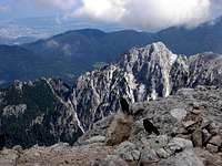
We enjoyed the view from the peak and saw that our decision was right as the following part of the Ponza chain would have been a long story with the heavy rucksacks. After a few photos we returned to our luggage and started to descend.
The first stage of the descent was totally new for us as during the ascent we missed this part for the "No way". It was again a mixture of scrambling and via ferrata. Finally we reached the spot where we had deviated to the wrong direction two days before.
I was happy to do the Via della Vita in both directions as the view was different when we were going downhill (I know that it shoud be the same, but it still looked different. Maybe only should have to turn back more often during the ascent:)
Finally we got back to the car at the seven dwarwes, and drove back home, tired but contented.


Comments
Post a Comment