Toggle navigation
Mountains
Routes
Images
Trip Reports
Forum
What's New
People
Areas & Ranges
Articles
Trailheads
Canyons
Huts & Campgrounds
Albums
Logistical Centers
Fact Sheets
Lists
Custom Objects
Gear
Plans & Partners
WELCOME TO SUMMITPOST
SIGN IN
REGISTER
Kaluxung / Kalurong 6674m
Additional Parents
Image
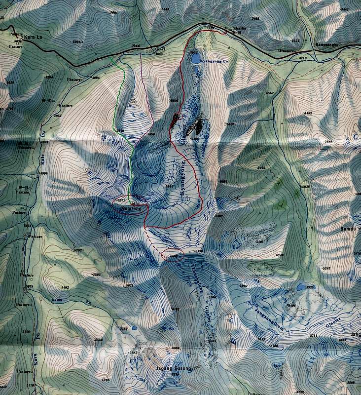
Map of Kaluxung
View High-Resolution Image
Map of Kaluxung
Extract from the 1:50'000 Noijin Kangsang map
with
Kaluxung main summit (6674m)
,
Kaluxung South (6536m)
and
Jagang Susong / Gyalongsum (6249m)
.
in red:
North-East route
in green:
North ridge route
« PREV
NEXT »
Bruno
on
Mar 19, 2009 6:18 am
Comments & voting
Other parents
Lat/Lon:
28.83686°N / 90.21956°E
Image Type(s):
Alpine Climbing
Image ID:
499192
2116 Hits
73.06
% Score
3
Votes
Log in to vote
Comments
No comments posted yet.
to post!
Don't have an account?
Kaluxung / Kalurong 6674m
(Mountain/Rock)
« PREV
Viewing
#46 of 46
GALLERY
You are at
the Last
Image
Bruno's Image Gallery
« PREV
Viewing
#334 of 339
GALLERY
NEXT »
×
You need to login in order to vote!
User Name
Password
Remember me
Forgot your password?
Log me out when I close my browser.
Keep me logged in all the time.
sign in as a user
Don't have an account?
Register now for FREE
Rating available
Suggested routes for you
People who climb the same things as you
Comments Available
Create Albums
Register Here


