
|
|
Mountain/Rock |
|---|---|
|
|
28.83686°N / 90.21956°E |
|
|
Mountaineering |
|
|
21896 ft / 6674 m |
|
|
Overview
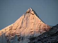
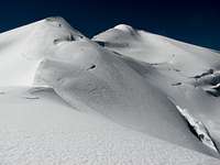
 Kaluxung North (6674m) and South (6536m) from the west
Kalaxung (or Kalurong) is a mighty peak culminating at an altitude of 6'674m, situated south of Karo La pass in Central Tibet.
It belongs to the Lhagoi Kangri belt, a heteroclite juxtaposition of sub-ranges squeezed between the Yarlung Tsangpo (Brahmaputra) river to the north and the High Himalaya to the south.
Kaluxung is the second highest mountain of the massif around Karo La ,after 7'206m high Noijin Kangsang. Prominence of Kaluxung is 1458m, with a saddle located further south near the Tibet-Bhutan border.
The mountain has two summits: the North Summit at 6'674m (GPS 6'686m) and the slightly lower South Summit at 6'536m (GPS 6'551m), connected through a saddle at 6'314m. Distance between the two summits is around 2km. Both summits offer very fine views of Noijin Kangsang to the north, Yamdrok Yumtso lake to the east, and the remote 7'000m peaks at the Tibet-Bhutan border to the south. Around Kaluxung, a few lower but technically more challenging 6'000m peaks are still unclimbed.
The ascent of Kaluxung from the north-east following the main glacier does not present any important technical difficulty or objective danger. It can be an ideal target for climbers wanting to acclimatise before attempting Noijin Kangsang.
Climbing history
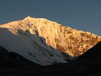
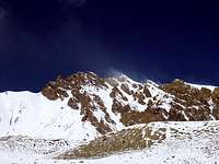
 Huge overhanging meringue on the north ridge
First ascent
Despite an easy access and low technical difficulty, Kaluxung has remained surprisingly unknown, and was first successfully climbed by a Japanese team in September 2005 only!
According to the report of a German expedition, who attempted neighbouring Noijin Kangsang at the same period, the Japanese party was a huge expedition consisting of seven elder Japanese climbers (average 66 years old) supported by eight climbing Sherpas and huge amount of materials (bottled oxygen, several hundreds meters of fixed ropes, etc.).
The expedition lasted from 7 September till 4 October 2005, and the Japanese installed one base camp and three high camps (Camp 1 at 5600m, Camp 2 at 5800m and Camp 3 at 6160m). Finally, the main summit was reached on 28 September 2005. A short video of the first ascent can be found here.
Second ascent
After a failed attempt on Noijin Kangsang, the German party mentioned above moved its BC to the foot of Kaluxung, which they believed to be 6247m high Jetung Chusang.
To the big surprise of the Germans, they meet some members of the Japanese expeditions, who told them that the mountain had another name and was not 6247m, but more than 6600m high… The confusion lies in the fact that Jetung Chusang is a minor summit south of Kaluxung, which is known on the maps as Jagang Susong or Gyalongsum (6249m). (It seems however that Kaluxung is also known locally as Jetun Chusang, and the reference book “Tibet – Le guide du pelerine, p. 667” also gives the name of Jetun Chusang for Kaluxung).
The German installed two high camps at 5600m and 6160m, corresponding to Camp 1 and 3 of the Japanese. According to the Germans, the Japanese unfortunately did not only left footprints on the mountains, but also cooking pots, snow pickets, toilet paper, etc…
Following the fresh trace and fixed ropes left by the Japanese, the Germans reached the summit on 1st October, three days only after the first ascent. They packed the mountain in 4 days only, compared to the several weeks needed by the Japanese. The expedition report of the German can be found here, with some media report here.
Third ascent
Comparatively, the third ascent looked more like a weekend tour rather than an expedition. On 24 October, I climbed 6121m high Mount Qunyang, a minor peak located at the other extremity of the range northeast of Noijin Kangsang.
The following day, I trekked back to the main road and decided to try my luck on Kaluxung (at that time I did not even know its name), through a route I had visualised on Google Earth, and which resulted to be the same route climbed by the Japanese and German two years before.
In the afternoon of 25 October 2007, I started from the main road at 4800m and set up my camp on a moraine near the icefall at 5322m. I took an early start the following day and reached the main summit shortly before midday. Back to the saddle between the North (main) summit and South summit, I climbed also the south summit (possible first ascent), before returning to my camp on the moraine, which I reached at around 5pm.
Further attempts
The following winter, SPer Corax made an attempt on the more challenging North ridge.
Getting There
See Red Tape section for travel restrictions in Tibet.From mainland China to Tibet:
By train. Since the opening of the Qinghai-Tibet railway in 2006, train has become a very convenient and popular way to travel to Lhasa. The new line between Golmud and Lhasa crosses the Qinghai-Tibetan plateau in a 1142km journey, most of it above 4'000. At 5'072m, Tanggula is the highest railway pass in the world. Trains are very comfortable in both first class (soft sleeper) and second class (hard sleeper). Third class (hard seat) is much cheaper and also OK if you don't mind sitting for quite a long time. During the peak season, trains are usually fully booked, so tickets need to be purchased as soon as they are on sale (usually 10 days in advance). There are currently direct trains to Lhasa from Beijing (47h), Chengdu (48h), Shanghai (49h), Guangzhou (56h) and Chongquing (47h). Trains can also be boarded on the way at Xi'an, Lanzhou, Xining or Golmud.
By road. Four main roads are connecting Tibet with Xinjiang, Qinghai, Sichuan and Yunnan Provinces. These roads can be officially travelled by organised tour groups only, but an increasing number of independent travellers and cyclists are succeeding to travel through.
Flying. Daily domestic flight to Lhasa from main Chinese towns (flights via Chengdu).
From Kathmandu (Nepal) to Lhasa:
Overland. Foreigners can enter Tibet at the Dram/Khasa/Zhangmu border only if they are member of an organised expeditions or tour group. The travel on the friendship highway to Lhasa offers fine view on Shisha Pangma (8027m), Cho Oyu (8201m) and Chomolangma (8850m).
Flying. Daily flight Kathamdu-Lhasa from spring till autumn. In winter, once or twice weekly.
From Darjeeling (India) to Lhasa:
Overland. The historic trade road between Darjeeling in Sikkim and Lhasa passing through Nathu La, Yadong and Gyantse has reopened for trade in 2006 after 44 years of interruption. It is currently closed for travellers, but according to official statements, it should open for tourism in 2011.
To the mountain:
 Panorama from Gampa La: Yamdrok Yumtso with Noijin Kangsang on the background
The last stretch has been asphalted at the end of 2007, shortening the travel to about three to four hours. Leaving from Lhasa, the road first crosses Yarlung Tsangpo River (Brahmaputra), before climbing Gampa La (4800m), where there are fine views on Yamdrok Yumtso and Noijin Kangsang in the background. Kaluxung can be observed left of Noijin Kangsang.
After passing the small town of Nagartse (several hotels and restaurants), continue further up towards Karo La (5036m). 19 km after Nagartse, you will see on your right a small motorable track heading towards Noijin Kangsang BC. Continue on the main road and stop 3km further up (22km from Nagartse, 6km before Karo La) near the bridge at the road construction compound. This is the good place to cross the river and start your climb to Kaluxung!
 Beautiful face on the road to Kaluxung (near turn off for Noijin Kangsang BC)
An approach from Shigatse through Gyantse is also possible, and is worth to be considered if you have just arrived in Lhasa and need a few more days for acclimation. In that case, stop 6km after Karo La on your way down to Nagartse.
Thanks to its proximity to the main road connecting Lhasa to Gyantse, Kaluxung would represent an ideal objective for solo climbers or small groups without logistic support. The area also offers some interesting challenges for more ambitious climbers. Do consider however the red tape chapter below.
Red Tape
Regulations for entering and travelling within Tibet can change rapidly, so check on travellers' websites for updated information.To enter China:
For most nationalities, tourist visa valid for 30 to 90 days are issued within a couple of days (or even a few hours) at Chinese Embassies and consulates abroad. Long duration Chinese visa (6-12 months) can be obtained in Hong Kong.
Tourist visa can be prolonged at local PSB (Public Security Bureau) twice for the duration of one month each time. However, it can be quite difficult (or event impossible) to extend your visa within Tibet if you are not part of a tour group.
To enter and travel within Tibet:
Foreigners need the following documents to enter and travel within Tibet:
Tibet Entry Permit (issued by Tibet Tourism Bureau)
Tibet Entry Permit is usually requested when you buy a train or flight ticket. Local travel agencies in Beijing or Kathmandu can arrange in a few days your Tibet Entry Permit together with your train/plane ticket to Lhasa.
Alien Travel Permit (issued by Public Security Bureau – PSB)
Lhasa and Shigatse cities, as well as a few tourist spots around Lhasa have been declared open to foreigners, so that you don't need any additional permit anymore. However, as soon as you want to move into areas closed to foreigners, you need an Alien Travel Permit (ATP), which lists the places where you will be allowed to travel. Cost of an ATP is 50 RMB.
Climbing Permit (issue by China Tibet Mountaineering Association – CTMA)
Due to the current travel restrictions in Tibet, most peaks are usually proposed within a package including transportation and logistics by China Tibet Mountaineering Association (CTMA). The lump sum varies depending on the number of climbers, and bargain is possible depending on the service level you require.
Contact CTMA at the following address:
China Tibet Mountaineering Association
No 8 East Linkhor Road
Lhasa, Xizang/Tibet, China
Tel: +86-891- 6333687
fax:+ 86-891- 6336366
e-mail: ctma@public.ls.xz.cn
Camping and accomodation
Cheap hotels and restaurants can be found in Nagartse, 20km away from the peak. Camping sites along the north-east route are described under Routes and difficulty.There are also plenty of nice trekking and camping possibilities around Karo La. Previous acclimation to the altitude is required!
When to climb
Spring (End of March till beginning of June) and autumn (End of September till beginning of November) are the best seasons to attempt Kaluxung. Winter climb is also possible, but you will need extremely warm equipment.Winds are usually stronger in spring than in autumn. Weather is instable during the summer rainy season (monsoon).
Routes and difficulty
Northeast route: the "normal route"
 Kaluxung north-east route
The north-east route is quite intuitive and is the easiest route for both North and South Summit.
It starts 6km below Karo La near the small Kyangyong lake (hidden from the road), and then follows the huge Kyangyong glacier in a north-east curve up to the pass between the two summits at 6'314m. Except a heavily crevassed zone just above the icefall, this route is quite safe from objective dangers and does not present important technical difficulties. It is however a very attractive route for its impressive glacier landscape and atmosphere.
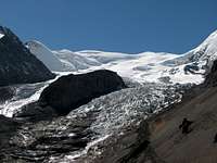 Kaluxung Icefall. Kaluxung Icefall.The climbing route follows the moraine on the right. | 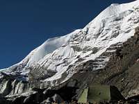 Camp on the moraine. Camp on the moraine.Near the icefall, altitude 5320m. |  Kyangyong Glacier. Kyangyong Glacier.Kaluxung South in the background. |  Near the summit. Near the summit.Bhutan Himalaya in the background. |
For a complete route description, check the Northeast route page .
 Kaluxung north ridge
North rigde
Another interesting and much more challenging route starts at the foot of the north face, which can be seen from the road.
The route follows the long north ridge and overlooks the Kyangyong glacier to the east. This route has been attempted in late winter 2008 (see route description here) till around 100m below the summit, but was aborted due to the dangerous cornice and harsh winds.
 Kaluxung west route would lead between North (left) and South (right) summits
West approach
Another route seems possible attacking the mountain from the west in the Kale Pu / Kara Pu valley . Steep ice climb would lead directly to the pass at 6314m between both summits. The final stretch follows the normal route.
.
GPS waypoints
GPS waypoints are around 10-20m higher than the altitudes given in the maps.P5054m: Lat. 28°53'38"N Long. 90°10'18"E Karo La
P4800m: Lat. 28°54'00"N Long. 90°13'40"E Roadside (approx. location)
P5322m: Lat. 28°52'25"N Long. 90°13'15"Camp
P6314m: Lat. 28°50'41"N Long. 90°12'37"E Pass
P6686m: Lat. 28°51'02"N Long. 90°12'25"E Kaluxung North Summit
P6551m: Lat. 28°50'13"N Long. 90°13'10"E Kaluxung South Summit
Maps
Google Earth is a precious tool to prepare an expedition to Kaluxung, as the whole route can be visualised quite clearly. Note that there is a small shift of around 3" between Google Earth and GPS readings.The Lhanzhou Institute of Glaciology and Geocryology has produced an excellent 1:50'000 map of Noijin Kangsang area, which is published by Xi’An Cartographic Publishing House (1997). The map exists in both Chinese and English versions, and includes Kaluxungs and all other important peaks in the area. Check here or here for order.
 1:50'000 map of Kaluxung
in red: North-East route
in green: North ridge route
Trekking and other climbs around Karo La
There are plenty beautiful trekking possibility around Karo La, as well as glacier climbs over 6'000m. See the Lhagoi Kangri area/range page for more information.The following peaks in the area have their own page on SP:

Links
Qinghai-Tibet Train Official WebsiteLhasa travel guide
Kaluxung (Kalurong) on peaklists: 8000ers.org , viewfinderpanoramas.org , peaklist.org
Kaluxung first ascent by Japanese team in 2005
Kaluxung second ascent by a German team