
-
 7271 Hits
-
 86.85% Score
-
 23 Votes
|
|
Mountain/Rock |
|---|---|
|
|
47.17253°N / 11.30862°E |
|
|
Scrambling |
|
|
Summer, Fall |
|
|
8596 ft / 2620 m |
|
|
Overview
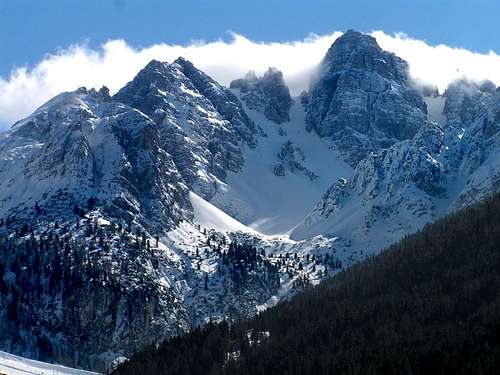
Marchreisenspitze is one of the more spectacular summits immediately surrounding Innsbruck. It allows a visitor with half a day to spare to sample the spectacular Stubai Alps. The limestone summit is reminiscent of Italy’s Dolomites.
Getting There

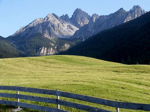
Farm behind Axamer Lizum
The closest trailhead is at the Olympic venue at Axamer Lizum, elevation 1564 meters. It is 9 kilometers as the crow flies from Innsbruck, or about 22 road kilometers, half an hour’s drive. Buses from the central bus station in Innsbruck take about 45 minutes. From Axamer Lizum there is a chair lift that operates all summer to Birgitzkopflhaus at about 2000 meters.
Another pleasant way to access Marchreisenspitze is to take the street tram from Innsbruck to Mutters Alm station at the top of the suburban village of Mutters, and then proceed to Mutterer Alm at the top end of the Mutterer-Alm-Bahn chair lift. This can be done by taking the chair itself (operates in late June, July and August) or mountain biking or hiking the pleasant service road (650 meters elevation gain, 13% grade). From the top of the chair, Trail 12 climbs a fairly gently 400 meters to Birgitzkopflhaus.
Equipment and Safety

Summit as seen from Ampferstein
The easiest route on Marchreisenspitze requires no equipment in summer beyond approach shoes or hiking boots. For the via ferrata via Ampferstein, some will be more comfortable with a ferrata set (a harness with shock-absorbing clips, which can be rented in Innnsbruck or purchased on line from Black Diamond and other manufacturers). However, this is an easy via ferrata, and without a ferrata set it equates only to scrambling YDS class 3-4 terrain.
The limestone on the via ferrata is quite solid, but on the upper east side of Marchreisenspitze there is some rockfall danger if you are close behind another party. Summer thunderstorms are common and quite dramatic; it can be a good idea to get over the summits by mid-day.
Routes

The scree slope leading to Malgrubenscharte. The peaks are Marchreisenspitze (L) and Malgrubenspitze (R)

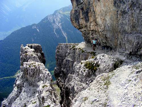
On the via ferrata between Ampferstein and Marchreisenspitze

The airy trail up the west side of the peak
East of the summit on Lustiger-Bergler Steig
Most ascents of Marchreisenspitze are on the Lustiger-Bergler Steig, a via ferrata that traverses the mountain from east to west. The via and all the associated trails are quite well signposted.
West Route
The easiest ascent is from the west side. Hike up the service road behind Axamer Lizum (Trail 18) for about one kilometer. Turn left onto Hochtennboden-steig and ascend into Lizumer Kar. Climb the scree on the south side of the cirque, aiming for Malgrubenscharte, the 2401-meter pass east of Malgrubenspitze. Turn eastward along the Lustiger-Bergler Steig and take the first opportunity to branch left up the southwest aspect of Marchreisenspitze. This route consists of YDS class 2 scree and airy trail hiking, as the Lustiger-Bergler Steig is not really a via ferrata in this stretch. The total vertical rise from Axamer Lizum is just under 1000 meters.
East Route
An enjoyable alternative is to climb the Lustiger-Bergler Steig from its northeastern end at the pass called the Halsl. This route involves much more rock scrambling on an easy via ferrata. It traverses the small summit of the Ampferstein, 2556 meters, from which it takes about an hour to pick your way to to Marchreisenspitze. As currently routed (2016), this route is a grade B ferrata or YDS Class 4 without ferrata gear.
Circuit
An excellent circuit can be made by taking the Birgitzkopfllift chairlift from Axamer Lizum to Birgitzkopflhaus (a restaurant), eliminating about 400 meters of ascent. From there, traverse easily about one kilometer on Trail 12 to the Halsl, and proceed up the via ferrata over Ampferstein and Marchreisenspitze. Descend the opposite side of the latter to the pass above Lizumer Kar. Going up via the Halsl pass, it takes two-and-a-half or three hours to reach the summit of Marchreisenspitze from either Birgitzkopflhaus or directly from Axamer Lizum, and a couple of hours to descend the far side back to Axamer Lizum.
Red Tape
There is essentially no red tape. Parking is free. If you plan to take the Birgitzkopfllift to gain height, you must wait until it opens at about 8 am and pay nine euros for the ride.B-24 Bomber Wreckage
On the service road/Trail 18 above Axamer Lizum, hikers pass some wreckage and a plaque with the following explanation:“On June 9, 1944, 500 USA air force bombers, each with a crew of 10, plus an escort of 172 fighter aircraft, left the Foggia region in southern Italy for the 19th airborne attack on Munich. Over northern Italy, about 20 minutes of flight time from their target, a group of bombers came under surprise fire from two attacking Messerschmitt ME 109 fighter aircraft of the German Luftwaffe and two US planes were shot down.

B-24 wreckage
“The plane that crashed here was hit on one of the right side engines, at which point the pilot, 1st Lt. Hugh White, left the formation hoping to reach neutral Switzerland with the damaged plane.
“To reduce the weight, the crew threw out all their equipment and armaments. When the plane was above Innsbruck airspace, it was hit by air defense cannon, so the pilot ordered his crew to take to their parachutes.
“About 11:00, the plane crashed on the Marchreisenspitze ridge . . .
“The crew landed in various nearby places: above the “Halsl” (Axamer Lizum), in Kreith, Sistrans and Rinn, on the Rinnerbuhel and on the Mutterer Alm.
“One crew member was captured and taken to the local Nazi officials, Gauleiter Hofer and Kreisleiter Dr. Primbs. When caught, the airmen were stripped of their weapons and transferred to Bad Aibling in Bavaria, where they were interrogated in detail . . . . After the war all of [the] airmen were released . . . .”
Marchreisenspitze (at center), with Ampferstein to its left, as seen from the road between Axams and Axamer Lizum.
Maps
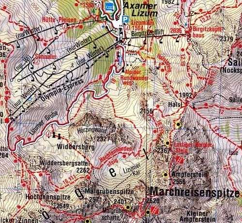
To view areas outside this illustration, use this online map tool for Austria.