
-
 14415 Hits
-
 87.76% Score
-
 25 Votes
|
|
Mountain/Rock |
|---|---|
|
|
40.44250°N / 105.7367°W |
|
|
Hiking |
|
|
Summer |
|
|
11909 ft / 3630 m |
|
|
Rodney Dangerfield might have appreciated this one.
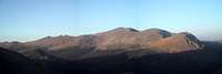 There it is! Click, enlarge, and then look for the small peak at the lower left-- photo by mico.
 Lava Cliffs
Overview
It's little more than a bump surrounded by higher, more spectacular peaks. Much of the scenery visible from the top is also visible from Trail Ridge Road nearby. The hike to the top is less than half a mile and climbs just a little more than 350'. So why bother?
Somehow, Mother Nature gave this "peak" just enough prominence to qualify as a mountain by Colorado rules. For some reason, somebody deemed this peak interesting or important enough to name it. Still, why bother?
At least seven reasons:
• Many visitors to Rocky Mountain National Park live at much lower altitudes and need some time to acclimate. Marmot Point, because it is a short hike but reaches almost 12,000’, is a good destination for one’s first or second day in Colorado. One does not have to worry about symptoms of altitude sickness occurring when one is several miles from the trailhead.
• Because the hike is short and easy, it is good for children who are pretty new to the whole hiking thing, or maybe even to walking.
• It’s a great “dessert hike,” something you do later in the day after having done a real hike or climb earlier. The day my brother and I hiked up Marmot Point, we had begun things with a hike up Mount Audubon in the Indian Peaks Wilderness and wanted to do something other than just drive around on Trail Ridge Road in the afternoon.
• It’s still a peak, and just about every peak deserves to be climbed.
• There are views of the dramatic Lava Cliffs that one does not get from Trail Ridge Road.
• It isn’t deep in the wilderness by any means, but the summit will probably be uncrowded.
• You can sit on the summit and look down on the cars crawling up Old Fall River Road and be glad that you’re not (for the time being) among them.
Scenic highlights from the summit include the spectacular Lava Cliffs, the Mummy Range, the Continental Divide to the south (including the snowy summits of Chief Cheley Peak and Mount Ida), and the tip of Longs Peak poking over the shoulder of Sundance Mountain.
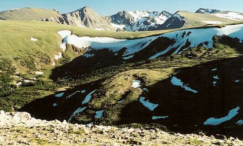 Summit View-- South
Getting There
Two miles west of the Fall River Entrance Station (or about 5 miles northwest of the Beaver Meadows Entrance Station-- go right at Deer Ridge Junction), take the turn to head west to Endovalley and follow the signs for Old Fall Road, which begins two miles from the turnoff. Follow Old Fall River Road, which climbs for 9 miles past some waterfalls and then above timberline to the Alpine Visitor Center on Trail Ridge Road. After about 8 miles, the road rounds a prominent bend before making its final climb past the Lava Cliffs and to the visitor center. Marmot Point is on the right side of the road, and on the other side is a pond. Park off the road and off the tundra.
Some important information about Old Fall River Road: the road is unpaved but easily passable for regular cars, it is open only in summer, and the traffic is one-way only. Have a good store of patience, as other motorists tend to drive maddeningly slowly and stop frequently.
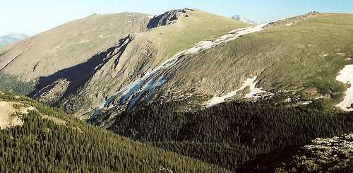
 Summit View-- Northeast
Camping
Because the one-way road that passes Marmot Point goes east-west, it makes sense to camp at Moraine Park or Glacier Basin; both campgrounds are off nearby Bear Lake Road, and the Bear Lake area is the gateway to much of the best RMNP mountaineering for day trips. Moraine Park is open all year, but Glacier Basin is open only from late May through early September. Both campgrounds take reservations, and reserving in summer is strongly recommended. Timber Creek Campground is on the west side of the park and is open year-round.
Fees are $20/night during summer months.
More information about camping, including links for reservations.
 Summit View-- Southeast
Red Tape
A seven-day entrance fee costs $20 per passenger car; it is $10 for pedestrians and for people on bicycles, motorcycles, and mopeds. An annual pass is available for $35, and the America the Beautiful Pass, which covers entry to all federal recreation areas for a year, costs $80.
Link to NPS Site
Rocky Mountain National Park
Topo Map
