
|
|
Route |
|---|---|
|
|
19.82360°N / 155.47079°W |
|
|
hike |
|
|
Half a day |
|
|
walk-up |
|
|
Approach
Park your car at the Ellison Onizuka Visitor Center at 9200 feet.
Route Description
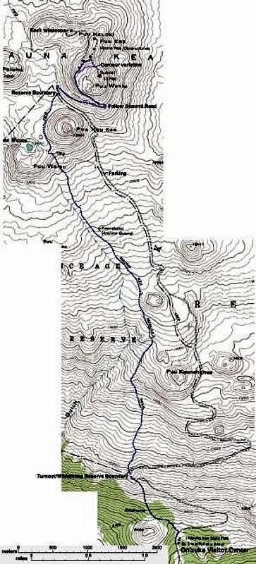 |
The Mauna Kea Trail, also known as the Humuula Trail, is the standard route for climbing Mauna Kea. The trail is approx 6 miles in length (one way) and it starts a few hundred feet north of the Visitor Center and follows the "abandoned dirt road", which diverges from the main (paved) road that leads to the observatories. The dirt road splits to the northeast and rejoins the main road at the 10000-foot level. Parking may be possible at a turnout on the main road, in front of the sign marked "Mauna Kea Ice Age Trail", but you should inquire before doing this.
From 10000-11000 feet, the hike climbs relatively steeply over well-behaved scree (perfect for fast descents). From 11000 to around 12800, the trail's incline lessens somewhat, and the dominant rock type becomes the blocky "a'a" lava rocks (more treacherous on descent).
The trail is well-marked with tall iron poles every 500 feet or so, making it nearly impossible to lose during the day.
A steep climb takes you from 12800 to 13100 feet, at which point you join a spur trail from the summit road. Soon after, the trail forks. The left fork leads to Lake Waiau (13020 feet). Take the right fork to reach the summit. The prominent cone to your east is not the summit proper, but rather 13441-foot Pu'u Hau Kea. Crest a 13200-foot saddle and slowly descend over 1/2 mile until you meet the summit road and obtain your first views of the telescopes.
It is customary to walk along the saddle road for the next mile, until 13700 feet. The true summit is separated from the rest of the summit plateau by approximately 1/4 mile and a small saddle. The final summit trail is located on the right side of the road, just before you reach the upper observatories. You may not be able to see it during heavy fog but a sign with a drawing of a hiker on it designates the start of the trail.
 |
 |
 |
 |
Essential Gear
This is a hike, not a climb. Go light and fast! Light weight hiking boots and warm socks are ideal unless there is snow, as the trail is in fine shape. Wind is omnipresent and summit temperatures normally hover around freezing, plus or minus 10° F. This makes for fairly cold but not extremely cold wind chills. Wear layers and dress accordingly.
Bring enough water and snacks for 4-6 hours of hiking. Lake Waiau will provide a reliable water supply in a pinch and may not require treatment, though the algae that greens its waters may put off many prospective drinkers. There are public Porta Pottys at both the upper and lower observatories.
Don't forget sunglasses and sunscreen!
Alpinist - Mar 12, 2012 12:41 pm - Voted 10/10
Humuula TrailThe signs posted along this route as of March 2012 state that this trail is called the Humuula Trail.
jerryn - May 4, 2013 10:29 pm - Hasn't voted
Summit RoadThis is well posted now -- at mile marker 28. From Kona it is a left turn and Hilo a right turn.