
-
 4066 Hits
-
 79.78% Score
-
 11 Votes
|
|
Route |
|---|---|
|
|
37.85640°N / 105.4847°W |
|
|
Hiking |
|
|
Spring, Summer, Fall |
|
|
Most of a day |
|
|
Short sections of YDS Class 2+ |
|
|
Overview
 Crossing Medano Creek
This scenic Sangre de Cristo route takes in one 12er (UN 12883), one 13er (UN 13153, alias “Medano Peak”) and some amazing views of Medano Lake and of surrounding mountains. It is a combination of on-trail Class 1, off trail (occasionally steep) Class 2 with a small bit of Class 2+ scrambling on Crestone Conglomerate between the two peaks. In addition to fine views, depending on the time of year, this route may serve up amazing on-slope wildflowers and even the chance to view the local herd of Bighorn Sheep. While much of the off-trail navigation takes place above timberline through the tundra, this route does involve a section of navigation through fairly dense forest, so solid navigation skills and the tools to support these skills are required.
NOTE: This route assumes snow-free conditions and does not take into account snow-season avalanche risks. Your specific route may vary significantly with snow present.
Distance: About 9 miles RT
Elevation Gain: About 4,225 feet net (cumulative gain higher)
YDS Class: 2+
Getting There & Route Map
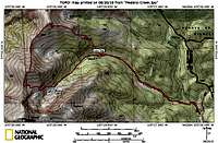 Route Map
 Getting There Map
To reach the Medano Lake Trailhead, follow these excellent instructions on the trailhead page built by SP Member csmcgranahan: Medano Lake Trailhead
Route Description
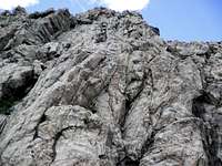 Ascending a rocky tower
 Descending the South Ridge of UN 12883
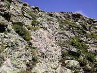 UN 12883-"Medano Peak" Saddle
 Southwest ridge of UN 12883
 UN 12925 from Medano Creek drainage
 Looking back up toward the Medano-Herard saddle
From Medano Lake Trailhead to UN 12883
• From the Medano Lake Trailhead parking area, travel roughly 2.5 miles to a stream crossing (stream comes in from the north).
• Leave the trail and head northwest through sometimes dense timber up the southeast slopes of N 12883. Use the gully as a guideline, but you may need to stay out of the gulley proper to avoid deadfall / debris.
• At timberline, begin trending westward across the slopes of UN 12883. No, the big red conglomerate block you see is not the summit.
• Continue your ascent up sometimes steep tundra to the broad, gentle summit of UN 12883.
From UN 12883 to UN 13135 “Medano Peak”
• From the summit of UN 12883, “Medano Peak” is approximately 1 mile away.
• Depart the summit of UN 12883 and descend the southwest ridge of UN 12883.
• On the southwest ridge of UN 12883, some easy scrambling on grippy conglomerate will be encountered.
• Steeply ascend almost due south to the summit of “Medano Peak.” A few rocky sections will be encountered near the top, but nothing greater than Class 2 and the rock is mostly stable.
From “Medano Peak” back to the Medano Lake Trailhead
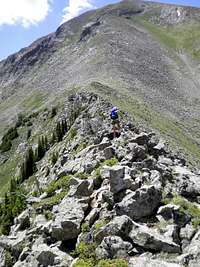
• Descend almost due-south for less than ½ mile along the south ridge of “Medano Peak” to the saddle with Mount Herard.
• From the saddle, look carefully for a rough, cairned footpath descending the east side of the saddle. Attentively following this path will drop you off at Medano Lake, where the official trail commences.
• From the lake, you still have about 3.5 miles of hiking to reach your vehicle, but the remainder of the route is all on-trail and mostly a gentle descent.
Essential Gear
 Saddle between UN 12883 and "Medano Peak"
• Standard mountain hiking gear & clothing appropriate to the season is needed.
• There is no water after leaving the trail and heading up the slopes of UN 12883, so pack plenty to drink.
• Map & compass and GPS, plus the knowledge of how to use them, are necessary.