
-
 25701 Hits
-
 72.08% Score
-
 2 Votes
|
|
Route |
|---|---|
|
|
40.24900°N / 105.604°W |
|
|
Scramble |
|
|
Most of a day |
|
|
Class 3 |
|
|
Approach
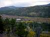
This climb of Meeker Ridge can be approached from two different trailheads. I will focus my description on the Sandbeach Lake trailhead, which is located next to the Wild Basin Entrance Station to Rocky Mountain National Park. (The alternative trailhead (slighly shorter route, less elevation, no National Park fee) can be reached from the Peak to Peak Highway (7) by taking CR-113 till the end. However, I have no idea what the parking situation is at this trailhead.)
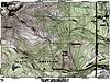
The trail from Sandbeach Lake trailhead (8400ft) is shown on the topographical map below. (The map shows a slighly different ascent than descent route.) The first 1.75-2.25 miles of the hike will be on trail, following the Sandbeach Lake trail. After passing the "Hole in the Wall" campground, and before crossing "Campers Creek", one should turn north and bushwack uphill for approximately 1000 vertical feet till reaching the saddle between Lookout Mountain and Meeker Ridge. This uphill section is fairly steep at parts, but not difficult.
I would recommend to leave the Sandbeach Lake trail at the "Hole in the Wall" sign to head up the south facing slopes of Lookout Mountain. This requires some navigation around/between some cliffs, but it brings you up towards the top of Lookout Mountain which provides a great view of the whole Meeker Ridge. Once you get close to the top of Lookout Mountain, you can either hike over the top or traverse around Lookout Mountain towards its saddle with Meeker Ridge at about 10500 ft.
For the descent I recommend a slighly more direct route (see topo) which cuts down to "Campers Creek" and then follows it until the junction with Sandbeach Lake trail.
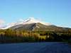
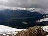
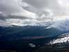
I highly recommend this hike due to its great views onto the plains, the Indian Peaks, and the Estes Park/Lumpy Ridge area. I assume that even during the summer, this is a route where one can find solitude in RMNP.
 |  |  |  |  |
Route Description
This route describtion starts at the saddle between Lookout Moutain and Meeker Ridge. From this point forward, the climb follows Meeker ridge for approximately 2.5 miles and 3400 feet of elevation gain.
The first part of the route goes from the saddle to treeline. This part is fairly easy and flat for longer sections, but the ridge is not always easy to locate. However, there are some cairns which point the way towards treeline.
Once at treeline, the ridge provides several highpoints for orientation. First are some "cliffs" at about 11400 feet which we passed on their north side. Then we stayed slighly north of the ridge and took an almost straight line towards a highpoint located at about 12000ft, which we also passed on its north side and then regained the ridge. From here we stayed close to, but on the south side of the ridge, till reaching another highpoint at 12400ft. The slope of Meeker ridge from the saddle up to this point has an average angle of 23% and does not pose any particular challenges (maybe class 2-). However, keep in mind that you already gained 4000+ft from the trailhead when reaching this point.
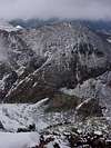
From the 12400ft highpoint towards the summit of Meeker Ridge, the climbing becomes more difficult (I would guess class 2+), the slope steepens to 33%, and the climb involves some routefinding in order to find the easiest way up. We stayed on the south side of the ridge till slighly above 13000ft, when we crossed the ridge and continued towards the top on the north side. This crossing of the ridge was the hardest part of the climb thus far and involved a few Class 3 moves. However, an easier crossing point from south to north can probably be found.
Once on the north side of the ridge, we followed the ridge towards the top of Meeker Ridge at 13850+ft. From this point the ridge towards the main summit is clearly visible and poses the biggest obstacle of the whole climb. The views of Longs Peak's East Face are also spectacular from here.
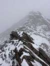
The climb along the ridge is rated as Class 3, but if the conditions are not perfect, the route is significantly harder. Along the whole route there is significant exposure and a fall/slip would most likely be deadly. On the downclimb from the Meeker Ridge summit there is one short section that is somewhat "nerve-racking" as Ryan Schilling describes it on the "Iron Gates" route page. From there on, the ridge traverse requires some scooting over the top of the knif-edge-ridge (there is no shame in putting 1 leg on each side) and then involve some travel along ledges towards the top of Mount Meeker.
From the top of Mount Meeker (13911ft), one can either return via the same route, or choose an alternative route. See Gerry Roaches book for alternative routes that lead back to the Sandbeach Lake trailhead.
 |  |  |  |  |
Essential Gear
During the summer there is no special gear needed, only the usual gear required for a safe hiking trip. However, since the hike is fairly long (11miles, 6000ft) and if off-trial for 7 miles, an early start is recommended.
During the winter I would guess that additional gear is needed, in particular to crossing from the summit of Meeker Ridge to the summit of Mount Meeker becomes difficult in snowy conditions.
 |  |  |
Miscellaneous Info
If you have information about this route that doesn't pertain to any of the other sections, please add it here.