
|
|
Mountain/Rock |
|---|---|
|
|
38.45220°N / 106.0175°W |
|
|
Chaffee |
|
|
Hiking |
|
|
Spring, Summer, Fall, Winter |
|
|
11707 ft / 3568 m |
|
|
Overview
| An ariel view of Methodist Mountain. Heavily forested as you can see. This vantage is looking at the mountain from the south. Both summits actually have communication towers on them. Methodist Mountain, because of its' prominence over Salida, is also used as a 'repeater station' for towns like Buena Vista further to the north.The Arkansas Hills are in the background.
Prominence: 807' Colorado Pks. Rank: 1453 Quadrangle: Poncha Pass YDS Class: Class-1 Lists of John (--website) | 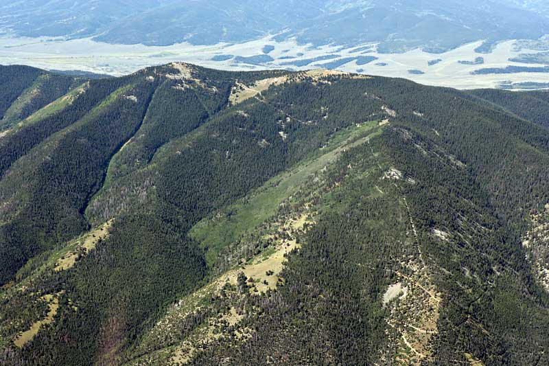 |
One of the more prominent mountains that stands over Salida is Methodist Mountain. This forested bulk of a mountain looms over Salida to the south and pretty much dominates the view. At 11,707', Methodist Mountain is the Sangre de Cristos' northern-most point. Everything north of Salida past the Arkansas River & Bighorn Canyon is commonly referred to as the Arkansas Hills. It is part of both the San Isabel and Rio Grande National Forests and lies on the boundary of Chaffee and Saguache Counties.
There is a well-maintained utility/county road that winds its' way to the summit. This makes Methodist only a class-1 mountain.
Of the towers at the summit, one belongs to Verizon Wireless and another belongs to the local broadband (telecommunication) provider.
The 100+ mile long Rainbow Trail (#1336) also traverses below Methodist Mountain on its' way over to Poncha Peak and Poncha Pass. Many people come here not necessarily to hike, but mountain biking is extremely popular. Seeing people on 4x4's (Jeep's and ATV's) is also common. The busiest season for visitors as expected is summer. Winter can be exceptionally windy.
And lastly, in regards to the name, this one is still up for debate. I still can't after MANY hours of researching and reading, can't find a legitimate and factual account of the name. Although, in old photo plates (glass plates), Methodist was being referred to as such by 1906-1907. I was able to find glass plates in historical archives taken from the mines above Tenderfoot Mountain in the Arkansas Hills showing Salida and Methodist mountain in the background. The mountain is labeled.
Upon further digging, a Methodist church was initiated and constructed on 4th Street and 'D' Street in town in 1897. Obviously I can't say for sure, but perhaps the mountain was named thus in honor of the church. Services/mass could have been performed on its' flat summit. In a rowdy railroad town prone to fights and immigration from Irish and Italians, any chance to impose order and civility would be seen as a good thing.
I have an e-mail/inquiry out to the Salida public library archival department for help. So, if they get back to me with more concrete beta, I'll post it here.
Getting There
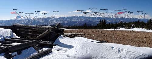
A Labeled View from the summit.
Once in Salida, proceed west down Hwy.50. About half-way through town, start to look for County Road #107. This will be on the left (south) side. Turn left onto #107 and continue following it south for a few miles. Eventually, #107 doglegs right. At this intersection, CR #108 (Terrace Drive) starts and continues to the left. This rough dirt road will end on the summit. Most people drive to the parking area that services Methodist and the Rainbow Trail. From the intersection of #107/#108, the parking area is about 1.2 miles further. The starting elevation here is around 8,900'.
If approaching from the north (IE: Leadville, Johnson's Village, Buena Vista), drive south on US.24 to Johnson's Village. US.24 will end and US.285 continues at this intersection. Follow this to Poncha Springs. Follow the signs for Hwy.50 east to Salida then resume the directions above.
For passenger cars, the road is rough, dirt and rock with some washboard sections. But a 2WD car could make it pretty far up the road if not to the first and lower summit. However, if the road becomes TOO rough, keep in mind, they're not too many places to back up and reverse course. It might be a good idea to simply park at the trailhead.
Red Tape

Northeast Shoulder
I don't know when the gate is opened for the season, but considering MOST gated roads open on or around Memorial Day weekend if not a bit sooner, I'd expect it to be open mid-late May. This road is a through-fare to public lands. So per county regulations, the road itself, remains public.
There are plans to improve and enhance signage on the county roads south of Hwy.50 and in between Cty. Roads #111 to #107. But as I understand it, as of now, it's a low priority of Chaffee County.
Also keep in mind, once on the summit, being SO CLOSE to major telecommunication towers like that, the broadband, radio waves & any other radiation waves can't be good for one's health. make your stay short!
Camping
Due to the property issues at the bottom, camping can't really be had until further up on the mountain. Much of the road traverse the northern and eastern slopes, so finding a level, flat spot to pitch a tent is going to be a hard sell. However, the summit is large, broad and flat. Plenty of opportunities exist there.- Heart of the Rockies RV & tent Campground
16105 West Hwy.50
Salida, Co. 81201
(719) 539.4051 (reservations)
This formal and developed campground has 45 RV sites and 25 tent sites. There is free wireless (you know, so you can Facebook & stuff!), hot showers, restrooms, picnic tables, fire-pits and even laundry.
This place is located 10 miles west of Salida in between mile markers #211 and #212. $20.00/$24.00 (meadow site/next to stream)
---Their Website
When to climb
This is a gentle mountain that caters well to all seasons. Summer and fall will be the most popular months. The mountain will be covered in hikers, 4x4'ing enthusiasts and mountain bikers. Not to mention, with fall, you have the added advantage of being surrounded by the yellows of the changing aspens.Winter can be a quiet time. Winds are generally high and with a northern approach, temps can remain deceptively cold despite sunshine. But the road makes for a great track for cross-country skiing or snowshoeing.
External Links
Mountain Biking/Hiking Trail System