
-
 18566 Hits
-
 82.48% Score
-
 15 Votes
|
|
Route |
|---|---|
|
|
37.03583°N / 111.9224°W |
|
|
Scrambling |
|
|
Spring, Summer, Fall, Winter |
|
|
Half a day |
|
|
Class 4 |
|
|
Overview
Not known to most people interested in world-famous Buckskin Gulch and Paria Canyon, the Middle Trail is a route that descends steeply into the heart of Buckskin Gulch about halfway into its narrows. It involves a cross-country desert hike (not completely obvious, but not terribly difficult to figure out, either) and then an exposed Class 4 scramble to reach the canyon floor. Reaching the remote trailhead involves sections of deep sand, so 4wd is highly recommended.
A day hiker who wants to do some exploring in Buckskin Gulch, which is considered to have the world's longest continuous stretch of narrows (about 12 miles, with the rims sometimes more than 200' above you and in places narrow enough for one to touch both walls with arms extended), may enjoy this alternative to the very popular Wire Pass approach that most Buckskin day hikers use.
For people hiking down Buckskin and then up Paria Canyon (about 22 miles, shuttle vehicle required) or down Buckskin and then down Paria all the way to Lee's Ferry on the Colorado River (about 45 miles), the Middle Trail also represents a place of escape if water or weather conditions necessitate it. Also, because one can scramble out of the canyon on either the north or south side where the Middle Trail reaches the canyon floor, this spot also represents a safe camping site.
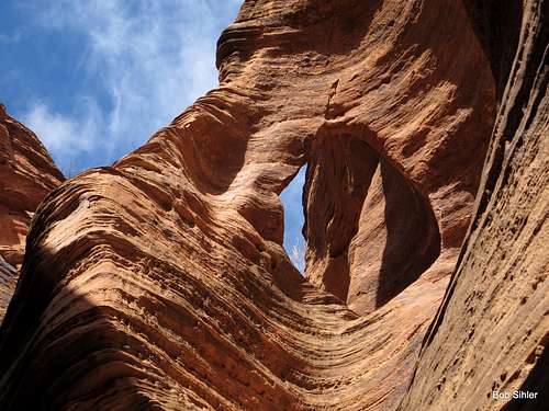
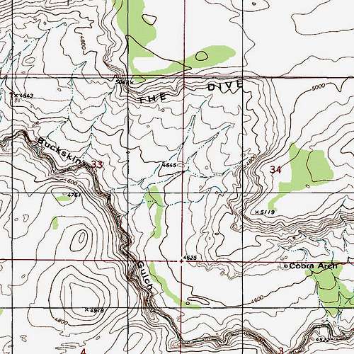
Cobra Arch: In the trailhead register there were several entries noting Cobra Arch as a destination, leading me to think the arch was somewhere in the canyon. That is not the case; Cobra Arch is a destination along the north rim of Buckskin Gulch and is reached by a cross-country route of about 4 miles RT. For more information about the hike to Cobra Arch, see here.
The arch below is not Cobra Arch, by the way.
Getting There
About 41 miles east of Kanab, U.S. 89 crosses the Paria River. Just west of the crossing is a road and a commercial property-- a restaurant and outpost. Turn onto this road-- #750-- and follow it south. Leave any gates the way you found them. Soon, the road climbs with Long Canyon on the right. This canyon appears to have some interesting narrows but is probably virtually untouched since it is not part of the wilderness area.After three miles, you pass under some power lines and near the end of the canyon. After that, the road heads into high desert country with plenty of sand, scrub, and cattle.
At junctions, keep an eye out for signs keeping you on 750.
After five miles, the road becomes quite sandy. I found I did not need 4wd on the way in but did need it on the way out because there were more, and steeper, uphill sections going that way. I was driving an old 4Runner that struggles to reach 65 on the highway, though.
At around 7.5 miles from the highway, the road reaches another gate. Look on your right for a small parking area (a really large juniper tree makes a nice spot to park beneath). This is the trailhead, and there is a sign marking it. The sign warns that the route ahead is hazardous, that it is a route and not a trail, and that users are supposed to pay a fee and hold a permit (you are supposed to go to the nearby Paria Contact Station afterward to do so or pay at the White House, Buckskin Gulch, or Wire Pass trailhead-- see the main page about locating these sites if you need to).
Route Description
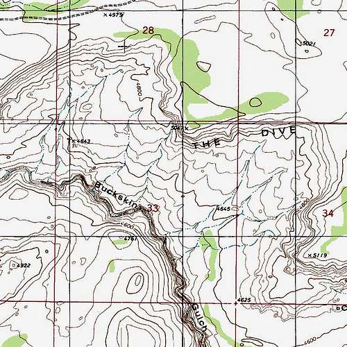
From the trailhead and register, hike uphill along a fenceline a short distance, passing the wilderness boundary, and then begin dropping down. It isn't easy to give a detailed route description from this point, but the basic idea is to work your way into the wash that passes immediately to the west of Point 4643 as seen in the first map below.
 |
 |
Once you are in the wash, follow it as it continues to approach the rim of Buckskin Gulch. There are some short pouroffs along the way, but they can be downclimbed or bypassed.
Occasional cairns will tell you you are still on course, but don't expect or look for a lot of them. Your best bet, when in doubt, is to look for signs of prior passage. Because much of the route is over sand, footprints are easy to spot most of the time.
Before the wash reaches the rim, however, you must exit and bear east (left). Do so as you approach the formation seen below.
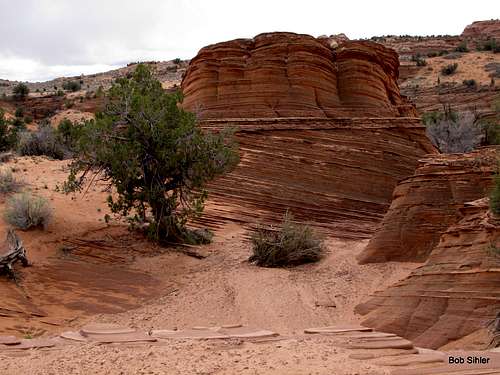 As you near the rim of Buckskin Gulch, watch for this landmark. At this point, leave the wash and work down and west (left) to continue the final approach to the rim.
Finally, you reach a point where the canyon bottom is visible below you:
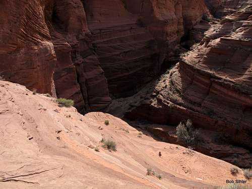
The approach is over. Now you will use one of three options to reach a wide ledge below before undertaking the final drop of 100' or so to the canyon floor.
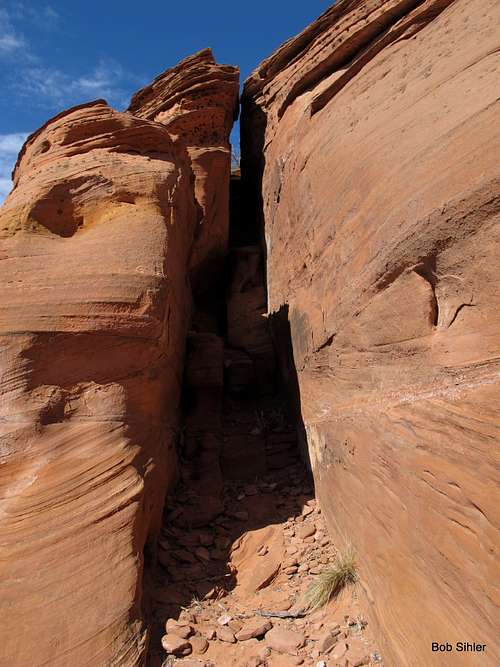
The first option is the hardest but the most straightforward. Head left to the sheer wall and then downclimb the crack/chimney feature you find (Class 4, exposed). Actually, you can follow this system straight to the canyon floor, also using the ledges adjacent to it at times.
Even if you use one of the other two options, you will still end up using this crack/ledge system for the finish.
The second option is to downclimb a narrow Class 4 chimney to the wide ledge between where you are and the canyon floor. Look for a cairn near its top to help you locate it. The following picture is obviously a view from below.
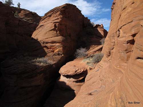
The third option is accessed from somewhere to your right as you face the canyon. (I tried out both the first and second options but only viewed this third one from the aforementioned wide ledge.) Although I'm not sure of the exact approach to it from above, that part can't be too tricky to figure out. This view is from its western end after I reached the wide ledge by a different option, harder but less exposed. It is merely a walk across this ledge, but the exposure is intense and the ledge is narrow. One slip means a fast and probably fatal trip to the floor of Buckskin Gulch.
At last, the final part awaits, whether you used Option 1 from the start or used 2 or 3 and then headed over. As mentioned before, it is the remainder of the crack/ledge system against the sheer red wall. It is also quite sandy, making the footing worse than you otherwise expect. Here is the pitch seen from the floor of Buckskin Gulch, and you can also see the upper portion:
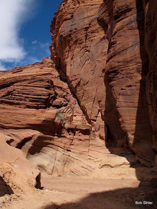
Downclimb the crack and ledges seen (exposed Class 4). My wife doesn't like exposure, so you can see (you might have to click and then enlarge) that I set up a 100' length of static rope for her to use as a handline. I found a nice, solid bolt to use as the anchor. However, there was nothing nearby to back it up. Just because the bolt was nice and solid when I was there doesn't mean it will be when you are. Remember to test all existing bolts and anchors as thoroughly as possible!
As you near the bottom, a little prize awaits: two bighorn sheep petroglyphs hundreds, maybe thousands, of years old--
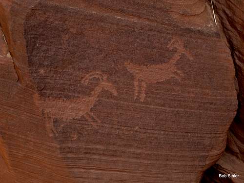 These are near the bottom of the final drop into Buckskin Gulch. Please don't touch them.
They are not the only petroglyphs around. From higher up, look high on the canyon walls for more:
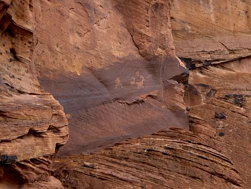 These are seen high on the canyon wall from the point where the approach is over and the scrambling descent begins. You may find yourself wondering how in the world the artist got there!
Thinking you might rappel down from the bolt and skip the exposed downclimb? I'd recommend a 60 m rope. Also, since your rope will go right over the edge of the drop, you would be wise to have some kind of padding. But I would still think twice about rappelling down. Remember-- no matter how sturdy that bolt seems, there is nothing good to back it up. A handline is one thing and a rappel is another entirely. How badly do you want to avoid 50' of Class 4 downclimbing?
The climb back up feels much easier.
Once you are on the canyon floor, go as far as you like in either direction. Depending on your skills, preparation, and tolerance for unpleasant conditions, you may only get up-canyon about a mile to what is called the Cesspool, a foul-smelling pool that is usually waist-deep. Or you may get about 4 miles down-canyon to the Rock Jam, a semi-technical downclimb where many through hikers rope up, though in April 2013 someone reported to me a fallen tree there that made the spot much easier (but conditions can change after every storm).
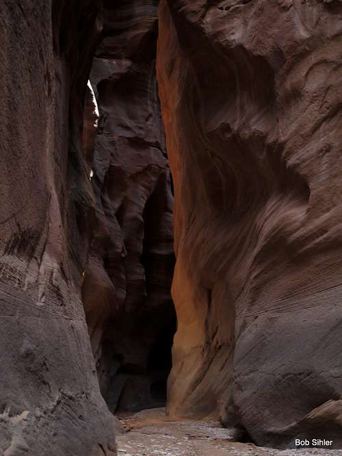
Here are some in-canyon scenes:
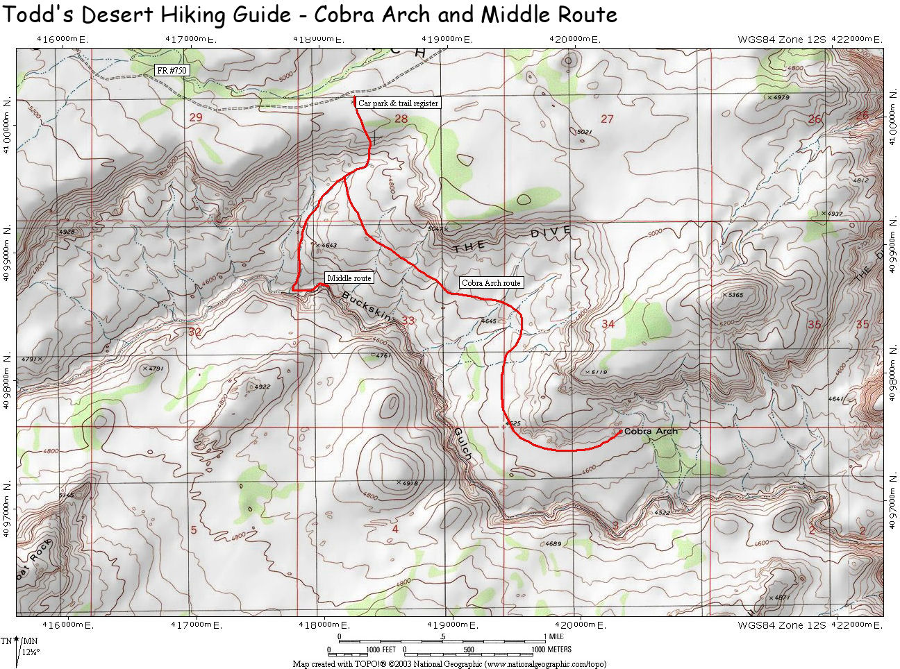
Here is a link to a diagrammed map of the route both down into Buckskin Gulch and to Cobra Arch. Please note: this is a link, not a copied image, and the author of this SummitPost page cannot give users permission to copy the map image.
 Up-canyon... Up-canyon... |
 |
 |
 Down-canyon... Down-canyon... |
 |
 |
Here is a link to a diagrammed map of the route both down into Buckskin Gulch and to Cobra Arch. Please note: this is a link, not a copied image, and the author of this SummitPost page cannot give users permission to copy the map image.
From the TH to the floor of Buckskin Gulch, this route is about 1.5 mi and loses about 700' of elevation. Although the hike back up is short, it can be quite tiring since so much of it is an uphill slog on sand.
Essential Gear
Standard desert hiking gear. Some may want to have at least 100' of rope for a handline if some party members would feel more comfortable with that. Or you may want the rope for lowering packs.
Water, and plenty of it, especially in summer! Even though the route is a short one, and even though the depths of the canyon may provide a cool respite from summer temperatures, the hike to and from the canyon will be all in the sun and the heat.