Carr Canyon Road - Reef Campground
The ranger station was closed at 5:30 when we went by it and darkness had already descended. We were looking for FR 368 which would lead us up to a campground that we intended to spend the night at. About 1/2 mile beyond the ranger station as we headed south on highway 92,
we found the turnoff and proceeded west on it. The first mile was paved but as soon as the road hit the forest boundary, it turned to dirt. A sign warned about illegal immigrants and smugglers and to beware of same.
Dennis Poulin and I had been to the top of Mt. Lemmon outside of Tucson earlier in the day and Dennis had gone on to make a fast ascent up Mt. Wrightson so it had already been a full day even before we got to the road. Dennis and I both travel in our own vehicles but we go caravan style and
so now both of us were headed up the winding and oft times narrow dirt road that led upward to where we wanted to go. At about the three mile mark from highway 92, we came to a sign that warned of
switchbacks for the next two miles. We had just avoided a pickup a bit before that was headed down the road and I was very glad that we hadn't met him on the switchbacks. These were tight and the road would climb steeply at times making us pay attention to our driving. After what seemed like an eternity, the road straightened out as we crested the top. We found
the turnoff to the
Reef Campground. As we drove in and checked out the sites, we noticed that we would be the only ones camped there. A flat area was found and we parked our trucks and settled in for the night.
I should mention that we had originally thought about hiking up from the Montezuma Pass area and following the trail north as most others do but summer rains had washed out the road and a reader on Arizona Hikers that was familiar with the area had warned me that the road to Montezuma Pass was closed.
The next day
Morning came early enough and after a quick breakfast, we drove up to the
end of the road and found the
Ramsey Vista Campground, which was still open. We parked just outside the campground at the
Carr Peak trailhead and the wind was so strong that anything that was light had to be secured or it would blow into oblivion. Despite the wind, the day was a beauty with ample sunshine that lifted my spirits as we headed up the Carr Peak trail. Before long, the trail started switchbacking up the side of Carr Peak and proceeded to gain altitude. Views opened up to the north and Ft. Hauchucha and Sierra Vista was visible in the distance, along with some type of blimp that was present above Ft. Hauchucha. The trail wraps to the southeast and then to the south of Carr Peak and when a side trail that goes to the top of Carr Peak is reached, the trail begins to descend towards the Crest Trail. Views over to Miller Peak reminded us that we still had some work to do.
The trail connected up with the Crest trail and soon dropped down a couple hundred feet to the interesting Bathtub Spring. Originally called Tub Spring, it was the site of the cabin of a miner named Max Baumkirchner. He and his wife and kids lived there circa 1900. In the Hiker's Guide to the Huachucas there is a photo. The bathtub is original; he hauled it up strapped between two mules. Interesting stuff, that is for sure. After a short break at Bathtub Spring, Dennis and I were ready to tackle the last two miles to the top of Miller Peak. The trail hit some head high brush a bit beyond the spring but that didn't last long as it continued on its way.
At about the one mile (from the peak) mark, we started to see debris left by illegals on both sides of the trail. Water bottles and orange juice containers mainly but other stuff as well. A comb sat neatly on a rock that was mid trail and Dennis didn't seem interested in adding it to his pack (I don't really need a comb with my hair style). The trail is really a pleasant one as it goes through the aspen trees that must really be colorful when fall colors are at their peak. Reaching the Miller Peak junction sign, we headed up the last 1/2 mile and 400 feet of elevation gain, again amazed at the amount of cast off debris left by illegal immigrants who seemed to have also been interested in climbing the peak.
Finally, the summit rocks of Miller Peak came into view and we soon stood atop the top, with the wind trying to blow us into Mexico, very visible just a few miles to the south of us. We spent about a half hour on top and enjoyed the view and having our Miller High, hiding behind a handy wind break left by the lookout that used to adorn the summit. A register left by Charlie and Diane Winger was read and signed into by Dennis and I but the register, in a baggie needs more protection for it to survive the winter.
Views were outstanding in all directions and made the effort well worthwhile.
All too soon it was time to head back to the TH and we returned the way we came but this was a hike I enjoyed, every step of the way. I would like to return to this area someday and hike up via the Miller Canyon which we met at the Bathtub Spring area.
Stat's 13 miles round trip with 3200 feet of elevation gain on the whole hike.
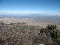
Views (Pics) from the summit
Here are a few shots taken from the summit of Miller Peak. I would have taken more but the wind made getting a stable shot very difficult and these three were the best of the ones I took
Our week in Arizona
Starting on Sunday, the 12th, Dennis and I did Mt. Rice, much of it cross country from a washout in the road on FR4472 that we didn't expect. The goal was the highpoint of Pinal county which is located just a few hundred feet from Mt. Rice's summit.
On Monday, we made the easy trek to the top of Mt. Lemmon and followed up with a drive down to Mt. Wrightson, which Dennis polished off in a bit over 5 hours. I was beat up enough from our 13 mile effort on Mt. Rice and realistic enough to know that I couldn't keep up with Dennis so I decided to save Mt. Wrightson and its 4000 foot gain for another day. From Wrightson, we made a 135 mile drive to our camping spot for Miller Peak (as described in this trip report).
Tuesday we did the 13 mile hike of Miller Peak and drove 120 miles to Rustler Park in the Chiricahua mountains where we spent the night at the 8400 foot level.
Wednesday we hiked 12 miles to the top of Chiricahua Peak, the county highpoint of Cochise county and then drove 110 miles to Shannon Campground and met up with Rick Hartman of Prescott Arizona.
Thursday the three of us hiked the ten miles required to get to the top of 10,740 foot Graham Peak, the county highpoint of Graham county. From there Dennis drove up and did the county highpoint of Greenlee county while Rick and I caravaned to a camping spot, meeting Dennis along the way who camped with us as we got ready to get Gila county the next day.
Friday, Bill Jacobs from Prescott joined the three of us and we hiked to the two highpoints of Gila county, one located at Promontory Butte and the other located at Myrtle Point, both spots that are the same height. Afterwards, I made the long drive home to Washington state. Dennis went on to do Mt. Union, the highpoint of Yavapai county later and then finished off his Arizona trip by picking up Haulapai Peak, the highpoint of Mohave county on Saturday morning before he made the long drive home to Oregon.
The minute I hit Idaho I began to miss Arizona since fog was waiting me on my trip home and I had rain the rest of the week in Washington.


Comments
Post a Comment