
-
 2246 Hits
-
 74.92% Score
-
 5 Votes
|
|
Route |
|---|---|
|
|
46.35667°N / 13.83685°E |
|
|
Hiking |
|
|
Summer, Fall |
|
|
Most of a day |
|
|
Hard, pathless hike-up |
|
|
Rating the Route (By Hiking Standards)

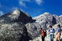
Towards the ridge

Below the summit
The grading system for hiking and scrambling routes is here.
0. General: From Velo polje, 1700 m to 2359 m, exposition S. First a steep hihe by a weak path, then strenuous ascent over steep grassy slopes and finally a quite exposed summit ridge (easy scramble). Gear: Good hiking shoes and poles.
1. Effort: cca 660 m, 2 h 30 min.
2. Power: 2 - Easy, mostly walk-up, but very steep.
3. Psyche: 3 - Medium.
4. Orientation: 2 - Easy (with a map and good visibility). Still, only a weak path (if at all).
Overview
damjan - The normal (south) ascent goes from the bottom left corner - to the scree field and around on the main ridge.
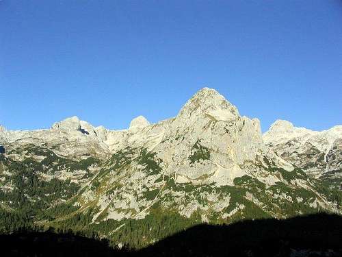
The nice ridge Mišelj vrh - Mišeljski Konec is a wonderful one day tour in the vicinity of Triglav. While masses are attempting to climb the highest mountain of Julian Alps, you scramble over the panoramic ridge in a perfect solitude. Mišelj vrh is the easternmost summit of the ridge. Its nicely shaped, rocky dome is beautifully seen from Velo polje or from Vodnikov dom (hut). Just above Velo polje it has a nice, elevated terrace, called Koštrunovec. Over there, by the east ridge an easy climbing ascent is also possible, offering you a possibility of a round tour. The continuation from Mišelj vrh by the ridge towards the west is also mostly easy. However, there are a few sharp ridge sections, which you avoid by the southern side.
The normal ascent goes on top from Mišeljska planina (alpine meadow), then towards Mišeljska dolina (valley), but soon you ascend the southern slopes to the main ridge (west of the summit). Then by the ridge on top.
Getting There

Mišeljski greben (ridge) from Uskovnica
See the main page of Mišelj vrh how to reach Velo polje (meadow). If you come from the valley, you need till Vodnikov dom (hut) some 2 h 30 min (from Pokljuka) to 4 h (from valleys).
Map: Planinska zveza Slovenije, Planinska založba: Julijske Alpe - Triglav. 1:25.000.
Route Description
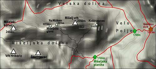
A map of Mišelj vrh
From Vodnikov dom (hut) you descend on the flat meadow of Velo polje, 1700 m, and continue by the marked path towards the SW on Malo polje and further on to Mišeljska planina (meadow), 1700 m. There you turn towards the NW.
The path into Mišeljska dolina (valley) is not marked, but in the beginning well traceable. Later the path turns towards the western direction. Soon after reaching the lowest part of the valley, we must deter right from the path.
Over the southern slopes of Mišelj vrh we hardly follow a tiny path. In the middle part we reach an unpleasant scree slope. It is wise to keep low, because rubble is not so fine there. So, we are gaining altitude, going towards the left and up. Above, we see the main ridge and aim our ascent towards the lowest point or just right of it (to shorten the ascent). The last part below the ridge is a steep grassy slope, which can be tricky if wet.
When reaching the main ridge, we are surprised by the fine view on the other side - Triglav is very close. We turn right and follow the ridge to the highest point. Just below the summit we need to scramble a little. The ridge is also quite narrow and exposed there, but with some care will not make any difficulties.
Descent: By the same route.