-
 14938 Hits
-
 84.27% Score
-
 18 Votes
|
|
Area/Range |
|---|---|
|
|
45.88430°N / 7.02160°E |
|
|
12086 ft / 3684 m |
|
|
Overview
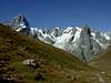
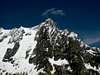
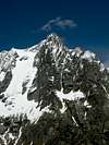
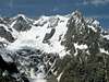
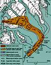
Entirely located in Italy, on the Grandes Jorasses-Leschaux-Talefre sector of the Mont Blanc massif, this rocky group is made by four summits: Mont Greuvetta (3684n.), Mont Rouge De Greuvetta (3477 m.), Petit Greuvetta (also called Punta Bosio, 3226 m.) and Mont Vert De Greuvetta (2873 m.). In the suspended valley between the arms of the group lies the Greuvetta glacier.
Of all the overlooked peak of the MB massif, the Greuvetta (or, incorrectly "Gruetta") group has a sort of special place. Standing between the massive shadow of Grandes Jorasses, and the up-and-coming climbing area of the Aiguilles de Triolet, the four Greuvetta peaks have a tremendous collection of walls, ridges and pillars of great esthetical interests and complexity - still largely "undeveloped". Seen from below, the Greuvetta group look beautiful as few other mountains are in the Alps. And the general quality of rock here is far better than in many other more famous corners of the massif.
The "downside" (if one can call it that way) is that it's all very much in the "trad climbing" format, with little fixed gear, some long approach, a lot of solitude and a long descent from the higher summit of the group. But it's all quite fascinating for the most adventurous.
The REAL downside is that the current troubles with glacial surface has made the approach to the 600 m. high east face of Mont Greuvetta (a good looking granite wall if ever was one) quite problematic. As usual, check locally (Courmayeur) before you make an attempt.
 |  |  |  |  |
Getting There
From Courmayeur (Italy)
- By car through the Val Ferret car road until Arnouva (1793 m.).
- By the bus service – one trip each 40 minutes. In Courmayeur the bus can be taken from the Bus Station (near the tunnel highway entrance).
 |  |  |
Red Tape
In the area mineral and flower collection is forbidden. The same goes for making fires, and free camping under 2500 m. Hunting and fishing goes under local seasonal rules (ask in Courmayeur).
Remember that private access to the Val Ferret road is regulated from 1 to 20 August
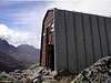
Hut
Gianni Comino Bivouac Hut (2430 m.)
Built in 1981, made in wood and metal, always open w/o warden, room for 10, property of the Mondovi section of the Italian Alpine Club , Via Beccaria 26, 12084 Mondovì (CN), tel. +39 174 63016 or +39 174/46776. In very good conditions. Water can be found 20 minutes away from the hut, in the Greuvetta glacier direction. The bivouac is named after Gianni Comino, the extreme ice climbing pioneer who formed in the 70’s a particularly prolific partnership with Giancarlo Grassi. Gianni died in 1980 while soloing a new direct route through the righthand seracs of the Poire, on the Brenva face of MB
Access: (diff. EE – easy and pleasant, but a bit exposed in the some part. May be suitable for kids accompanied by an expert)
From Arnouva, 1745m. (in Val Ferret, car park and a hotel/restaurant - reachable by car or using the bus service in 40 minutes from Courmayeur) follow the TMB path for few minutes, until you reach the start of a trail (on the left) marked "22" (ind. "Bivacco Comino"), that cross a small coniferous wood, then reach the Dora River. Cross it (two very narrow wood "bridges") then go up the moraine on the other side. The trail is marked with red points. After almost 1 hour, you reach a small basin where the trail turns left (there's some evident red arrow on the rock to mark the point). From here, the path goes up the slabby flank of the Grevuetta hanging valley, alternating very easy rock steps to small trail traces. Near the hut, there's one last rock step that's a bit steeper, but still easy. Be careful - you'll see the hut only on the last few meters.
Allow 2 hours from Arnouva
 |
When To Climb
Being mainly a venue for rock climbing, the natural period to access the Greuvetta group is summer (actually from May to October, depending on conditions - on June 1.
Given the quality of most of its rock, the Greuvetta group has not terribly suffered for the recent slate of hot, dry summers (especially the dreadful July 2003). I may have spent three days under the East face without witnessing any particularly significant rockfall (in comparison, it was depressing to see from Courmayeur, on almost daily basis, the Rochefort slowly crumbling down).
In winter, several thin ephemeral couloirs (all unclimbed) are formed on the East and SE face.
Routes Overview
I’ve never climbed personally the majority of these routes, so the following notes are taken from the available documentation or from friend’s advice. The list is not exhaustive – addition and correction are more than welcome.
Greuvetta basin
Until 1981, when the Comino hut was built, the hanging valley of the Greuvetta glacier was perhaps one of the most remote places of the entire massif. Even reaching the glacier itself was a complicate affair, first over a almost vanished trail on the left side of the Dora di Ferret river, then above a succession of rock steps alternating with ledges covered by a low and dense vegetation. The Comino hut (with its far easier access from the Triolet left hand moraine) has solved the problem of getting inside the valley. Unfortunately, the Gruevetta glacier has followed the fate of almost all its neighbours, and so getting to the SE ridge and the East face from the Comino hut is slowly becoming again a complex affair. Thus said, lovers of free climbing on solitary locations will love this place.
The rock is sound and compact in the lower middle of the E wall (where the majority of good routes is locate). Above, the terrain becomes far more unstable, and thus reaching the summit from the top of the pillars will alter substantially the seriousness of these lines.
- SSE ridge ( D+, III and some V, 1100m.) very long climb on decent rock, links Petit Greuvetta with the main summit.
- SE ridge (Carlini/De Lasser/Monte, 1942,TD+, V, A1, 550 m.) Exposed and delicate, sound rock in the lower part (recommended)
- ”Pilier De Vers Luisants” (Piola/Piola, 1990, ED2/3+, 6c, A1 or 7a+, 200 m.) Short, but most sustained route of the sector, with some very fine climbing on good rock. The length refers to the pillar proper untile the juntion with the SE ridge.(recommended)
- ”Le Karma" (Vogler/Vogler, 1980, TD+, 6b, 280m.) A nice route. Goes until the junction with the SE ridge. After the first ascension, Gaetano Vogler (Romain’s brother) suffered a dramatic accident while reaching the Greuvetta summit.
- Manera pillar ("Del Sorriso") (Ferrero/Manera, 1982,TD+, 6a, 380m.) A little know but extremely satisfying free route on good rock, Goes until the junction with the SE ridge. Very little gear in place, and the route is not always evident (recommended)
- Vogler pillar ("La Roue De La Fortune"). (Motto/Vogler, 1981, ED2, 6b, 7° or A1, 380m) The most “popular” route of the wall, even if the term is quite loose considering the solitary nature of Greuvetta. An exceptional free route. Well equipped line of descent (9 rappels, anchors must be inspected!)
- "Via Della Conca Grigia" (Manera/Meneghin/Ribetti, 1983,TD+, 6a, A2, 380m.) Possibly unrepeated, it’s the longest route on the left side of the wall.
- E face direct (Manera/Sant’Unione, 1974,TD+, 5a and A1, 550 m.) Sustained for the grade, and rather athletic, rarely repeared. Actually, it’s not direct at all – goes on the right border of the face.
- NE ridge (prob. D, III, 650m.) Delicate in the upper ridge (unrepeated)
- SW pillar to Mt. Rouge De Greuvetta (“Manera – Meneghin”) (D+, IV-V, 400 m). A fine and sustained rock climb on sun soaked rock, marred only by a slightly complicate descent (recommended)
- S ridge to Mt. Vert De Greuvetta (Bartels/Goedeke, 1975, AD+ (1 pass V), 300m). Another fine rock climb with little exposure, used to have relatively complex descent, but now usually rappelled over the next line(recommended)
- SE face of Mt. Vert de Greuvetta. (Franchini/Zizioli, 2002, 7a+, A0, 6b obbl.,300m). Easy to reach from the Comino Hut, follows a large diedre. Partially equipped, bring a full rack. Descent by rappel (recommended)
Freboudze basin
Dominated by the imposing and severe triangular East face of the Grandes Jorasses, and filled of the still lingering memory of the passage of great climbers like Giusto Gervasutti, Gaston Rebuffat, Joe Tasker, Giancarlo Grassi and Walter Bonatti, the rugged Freboudze basin has an atmosphere like nowhere else in the massif
Being the most easily accessible of all the Greuvetta faces, the Freboudze side is the one that has seen more traffic than the others (even if, of course, nowhere near the numbers of climbers seen in the more popular area of the massif!. It’s a complex face made of overlapping slabs and pillars, with rock similar to the Aig. Rouges Du Triolet, but more slippery (lichens).
Access to the base of the climbs is two hours from La Vachey (1670m). The old (and glorious) Freboudze bivouac hut used to be a perfect base for an earlier start, but in 1986 for some reason it was removed. To reach the higher Gervasutti hut (2800 m.) there’s some rock and icefall danger (some casualties here in the recent past), so my advice is to bring a tent and bivouac near the former Freboudze hut site.
There's now a new bolt equipped descent from the summit ridge, starting and the end of the last pitch of the Barthassat-Emery. 10 rappels.
- W ridge (normal route) (PD, 900 m). From the Gervasutti hut, glacier climb and a easy terminal ridge - complicated in bad weather ( recommended)
- SW spur (D+, V, 450 m). According to the FA party similar to the Grepon pillars (recommended)
- SW pillar (TD, V+, 450 m). Sustained.
- Grassi – Meneghin route. (TD, V, 600m). A trad classic, exposed and delicate (recommended)
- British Route (Creswell/Penning, 1988, TD, 6b, 600m). Another fine free climb repeated relatively often, opened entirely "clean". Tony Penning is now the foremost British developer of new routes on the Italian side of the Mt. Blanc massif, with several interesting lines on the Aig. Noire De Peuterey and satellites. (recommended)
- "Dromi" (Caneparo/Ciavattini/ Sordello, 1996, TD, 6a/6b, 600m). Contrarily to earlier reports, this is NOT a variant of the British Route, but an entirely indipendent line, merging with the Penning route only in the last few pitches. It's however an equipped route (95 bolts left in place, belays equipped with chains), and so much at odds with the typical "adventure ground" of this area. While the equipped belays can be used to retreat from the summit, they must be carefully inspected.. Also - except for the crux, the bolts are REALLY distant one from the other (even 15 m!)
- Barthassat-Emery (TD, V+, 700m). The most repeated route on this side, another trad classic, goes over a succession of fine slabs. May be wet after prolonged bad weather. (recommended)
- Red Tower direct (“Toccata & Fuga”) (TD+, VI, 500m). More straightforward than the former, and more sustained too.
- Bonatti route (D-, III-IV, 600m). First route opened on this wall, interesting and not particularly difficult, but a bit uneven.
North Face - Triolet basin
This 750m high, grim looking wall, overlooking the lonely Triolet glacier, is smaller but actually steeper than the nearby North Face of Grandes Jorasses. Almost entirely composed by colossal slabs (now more than ever exposed by the recent increase of summer temperatures), its main features - again, similarly to the NF of Grandes Jorasses - are two shallow spurs separed by a central couloir. The quality of rock is extremely variable (another point in common with the N face of GJ), and the danger of being hit by falling stones or ice is quite high, expecially near the central couloir. You should not get near this unless temperature is well below freezing point.
One of the motives of the nasty reputation of this wall is the unusually high fatal accidents vs. attempts ratio. With an handful of repeats of each routes, five climbers have died here, most notoriously italian ace Paolo Armando in 1970. Being quite large and slightly curved, this is a “t. rue” north face – i.e. it almost never sees any sun.
Access to all the routes is in 2/3 hours from the Triolet (Dalmazzi) hut.
- Grassi route (to pt. 3658m) (Grassi/Gabarrou/Barbolini/Boni/Freuchet, 1983, IV 5, 4c, 70°). Actually covering terrain between the north face of Greuvetta proper and the north face of Aig. Du Leschaux. Great mixed route, more sheltered than the others.
- Boccalatte route (Boccalatte/Castiglioni/Gilberti, 1937,TD+, 6a, A1, 750 m). A demanding climb in a particularly savage environment, but exposed to stonefall in the lower part. Higher become quite sheltered, but the section where the ice has disappeared, the rock is not very good. Serious - very few repetitions.
- Central Couloir (“Coracrazion”) (Charlton/Sylvester, 1986, V 5/6, 750m). According to the openers, extremely tough and difficult to protect. Severe stonefall danger.
- Mroz route (Bougerol/Mroz,1971, ED1/2, 6a, A2, 750m). A tough mixed route, very serious for the grade. Rarely repeated, almost always with a bivouac.
Camping
Free camping in the Aosta Valley region is not allowed below 2500 m. However, it's tolerated if you don't create hassles or particular troubles. This includes, of course, making fires in the woods!
Here's a list of camping in Val Veny, all accessible by car or by bus from Courmayeur. In strict alphabetical order:
- Camping Aiguille Noire (www.aiguillenoire.com, ) - in Val Veny, at Zerotta, near lower station of the chair lift. (tel. +39 0165 869041 Fax +39 0165 843097). A good place for families and big groups. Used to be also the cheapest, but price right now are almost the same everywhere.
- Camping Cuignon – in Val Veny between Zerotta and the military barracks (tel +39 0165 869073 Fax +39 0165 842861). This one is a bit of a question mark for me, because I don’t know anyone who’s been there. For outside it looks quite neat and smaller than Aiguille Noire
- Camping La Sorgente (www.campinglasorgente.net, ) – in Val Veny, in a clearing of the forest called Peuterey, exactly under the Mont Noir south face (tel. +39 0165 848209 or, in summer +39 0165 869089). The location of this one is gorgeous (the ancient forest nearby is said to have been a Celtic worship centre). They’re really climber-friendly, and the camping itself is well organised.
- Camping Grandes Jorasses ( www.grandesjorasses.com) in Val Ferret between Planpincieux and the golf course. (tel +39 0165 869708). Being near Planpincieux, it’s a lively and well placed on a partially wooden area.
- Camping Tronchey – in Val Ferret just in front of the entrance of the golf club, right under the monstrous Tronchey Wall of the Grandes Jorasses. (tel. +39 0165 869707). Nearby there’s Bar Tronchey (or “Chez Giulietta”), where at noon you can eat an incredible rabbit with polenta.
- If you’re willing to spend a little more, a nice alternative to camping can be the ( Chalet Val Ferret). It’s a seven room little hotel + restaurant at Arnouva, where the Val Ferret road ends – just in front of the opening of the Triolet basin. The place is beyond gorgeous, and you’re in a good position both for climbing and hiking. A guide who’s a friend of mine used it for his climbing stage for kids and was really enthusiastic. Also, you can ask the manager for any kind of indication on the nearest sport and trad climbs of the trendy Triolet area.
- On the other hand, if you don’t like camping and you’re tight with money, you can consider sleeping in one of the low altitudes “refuges”. There are the ( Elisabetta hut ), at the head of Val Veny near the Col De La Seigne, the ( Elena hut ) and the (UGET Monte Bianco hut) In all these places accommodation varies - the Elisabetta is quite spartan, the Elena almost a luxurious, the Monte Bianco somewhere halfway. If you want to consider staying there for several days, you’ve to book well in advance (In August and July these places become packed with hikers doing the Tour De Mont Blanc.)
Mountain Conditions
For all informations on the mountain conditions you MUST contact the Guides Company of Courmayeur (tel. +39 0165 842064; fax. +39 0165 842357; email info@guidecourmayeur.com). They’ve an excellent local weather service, and are always well informed on the conditions up there.
The quickest source of informations on the weather on the southern side of the massif is the webcam at
Remember that this cam "sees" only the central portion of the main ridge - Mt. Greuvetta is located one mile to the right. This very informative site has also plenty of informations on accomodation, place where to eat, etc. in the area.
If you check the "Courmayeur webcam" page, the "Val Ferret" webcam (located at Lavachey) gives you an idea on the valley floor conditions near Greuvetta
Trivia
On the right of the Greuvetta group lies the Triolet glacier, now relatively know for the high quality modern climbin routes of the Aiguilles Rouges. However, the Triolet basin achieved another kind of notoriety in XVIII century, in the aftermath of a catastrophic rock avalanche that entirely destroyed two settlements in the valley (Amerion and Triolet) and was one of the largest ever records.
In the night between 12 and 13 September 1717, a relatively limited area of the so called Aiguille De L'Eboulement ("the rockfall peak"!) collapsed. For several reasons yet to be clearly understood, the debris gained much more velocity than what normally happens, literally skiing down the Triolet glacier, wiping out the two hamlets (in the process killing several families of herdsmen and all their cattle) and, after hitting the slopes on the opposing site of the valley, continuing its rush down the valley, stopping near Ferrache .
The size of the whole event was staggering. According to a landmark study published in 1980, "The evidence suggests that the rockfall had a volume of 16-20 million cubic meters and descended 1860 meters over a distance of 7 kilometers in but a few minutes". Its horizontal terminal velocity may have exceeded 125kph. While widely studied by geologist in the next 250 years, the rockfall is still poorly undestood, and, given its size, the subject on several controversies. In 2003 a team from the Paris University has been dispatched to val Ferret. Using seismic techniques, they've collected enough data to publish a forthcoming study that may be the definitive on the subject.
 |