
|
|
Route |
|---|---|
|
|
14.53399°N / 88.68011°W |
|
|
Hiking, Scrambling |
|
|
Spring, Winter |
|
|
A few days |
|
|
Overview
This loop route is a fantastic and scenic adventure and includes the easiest route up Montaña del Celaque as well as an alternate loop route and side trips. The mountain is very beautiful and with strange flora and fauna. We saw monkeys and owls while camping out and with a lot of luck you may see more. Climbing Montaña de Celaque.
Getting There
Several (very crowded!) buses a day run from Santa Rosa de Copan to Gracias (one in a half to two hours). Santa Rosa de Copan itself is easy to reach as it’s on the main route between San Pedro Sula and Copan.From Gracias you can walk, ride a horse (ask around town or at the Hotel Guancascos) or take a taxi to the trailhead. If you want a really early start, hire transportation at the Hotel Guancascos.
The trailhead is 7 kms (4 miles) from Gracias. To reach it on foot, walk south from downtown to a tiny suburb known as Mejicapa. From there cross the bridge and follow the road west. This road will take you past several farms and then to the trailhead. Make sure to stop along the way and get your permit to climb the peak.
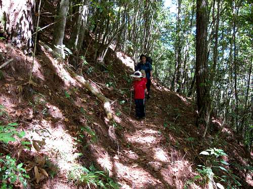 This is part of the beautiful open forest on the lower slopes of the Montaña de Celaque.
Route Description
From the trailhead (1200 meters), follow the road (sometimes closed) past the small Doña Alejandrina Comedor (restaurant). Just beyond is the old hostel Centro de Visitanes. The hostel is now closed and all that’s left is the concrete walls and foundation, but you can still camp there. From the hostel, the next section of the route has several variations.Variation A:
You can head straight and follow the trail along the pipeline until you reach a river crossing (Rio Arcagual) and then cross there to the other side and to where you meet the trail on the other side of the river.
 River crossing on Variation A.
Variation B:
If you want to cross the river on a bridge, rather than without one, instead of heading straight at the hostel, take the trail left and down to the river. Follow the river a ways before crossing on a bridge and continue on the trail. Not long after crossing the river you will reach a junction with the Sendero El Gallo (Rooster Trail) which is to the left. Continue straight and along the river. This route joins Variation A before climbing the steep switchbacks.
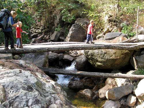 River crossing on Variation B.
Continuing on with the route:
The route begins climbing a steep slope via some nice switchbacks. Near the top of the switchbacks is another junction. The trail to the right heads to an overlook of a big waterfall (Cascada Lucia) if you have time to explore it. Continuing along the main trail, you will cross several gullies and small creeks. Eventually you will reach the Campamento Don Tomas at 2060 meters. The old refugio is completely unusable, but you can camp here. Please pack out your trash. Water is available just before you reach the campsite.
Not far beyond the campsite you will reach another junction with the Sendero de Gallo. This will be discussed later. Continue right on the main trail and towards Celaque. The climb is sustained and steep in places before reaching the summit plateau.
 This is part of the long, steep and slippery scramble which is the crux of the climb up Montaña de Celaque.
Once on the summit plateau there is another campsite, the Campamento El Naranjo at 2560 meters. There was also a crude hut here, but bring a tent just in case. You are now in the cloud forest and it is very wet.
The cloud forest on the summit plateau is really interesting and the trees are draped in moss. The summit is still quite a ways from here. The trail from here on is not in as good as condition, and you have to climb up and down steep inclines and under and over logs and mud. After all, this is the jungle!
 When climbing Montaña de Celaque sometimes you have to go under logs. Luckily this one is easy. Some of them you either have to crawl under or climb over the logs.
The route is marked with plastic ribbons so keep a close eye on the trail and to your location. Along the way are huge and weird hanging cactus vines, something I’ve never seen before anywhere else in the world.
 I've never seen anything like this. These are long cactus vines hanging from the trees in the cloud forest. A very unique feature on Montaña de Celaque.
Eventually and after climbing the last and steepest hill, you will find yourself on the summit (2849 meters). The views are limited, especially since it’s usually cloudy, but it’s an interesting place.
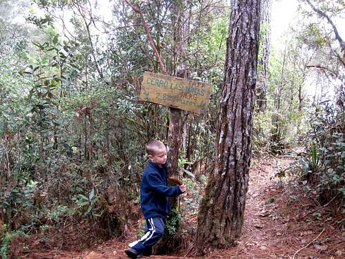 This is the Cerro Las Minas, the highest point on the Montaña de Celaque.
 After enjoying the summit and hike back through the cloud forest, follow the trail back down to the Campamento Don Tomas as mentioned above. If you want to do the full loop hike, take the Sendero El Gallo/Rooster Trail back. This involves climbing over another big ridge and the trail is more rugged and steep than the main one, but is really scenic. The Sendero El Gallo joins the main trail near the bridge not far from the trailhead.
 In the mist of the cloud forest the trees take on an almost mystical feel and look.
Time Needed
It is possible to climb the peak in one very long day by using the main trail, but two days is preferable to most.If you want to do the full loop, 2-3 days is needed. Doing the full loop and adding the extra side trip to the Cascada Lucia will take three days.
 Campamento Don Tomas.
Essential Gear
Bring raingear and full camping gear. Sometimes climbing the Montaña de Celaque is just like playing in one huge jungle jim. Bring good shoes.
ChristianRodriguez - Jun 5, 2009 1:22 am - Voted 10/10
more trails.Between El Narajando and the summit is another trail to continue the travesy of the mountains, finding a extra summit named "Guatemalillo" near to the another camp in great condition "El Quetzal", This trail takes 4 more hours looking the north of the mountians, crossing a couple of rivers, and small lagoons between a almost virgin jungle. From "El Quetzal" 20 minutes to the east is a tiny but beauty lagoon "Laguna El Bejuco". Is few visited, is possible to continue to other side of the mountain at north to a village named "La Virgen" I don't know more info about this last trail to "La Virgen".