
-
 2182 Hits
-
 78.27% Score
-
 9 Votes
|
|
Route |
|---|---|
|
|
46.56267°N / 12.02500°E |
|
|
Download GPX » View Route on Map |
|
|
Hiking, Skiing |
|
|
Spring, Summer, Fall, Winter |
|
|
Most of a day |
|
|
Medium hard hike up (T4/T3)) |
|
|
Introduction
This is a high and rewarding tour in wild and beautiful environment. You wil gain breathtaking views on Tofane group and reflect on the war times, when on those altitudes soldiers had to do all duties in all seasons and weather conditions.General Information
Exposition: From the bivouac on the route is exposed, even if the slopes below our feet are nowhere really vertical.
Orientation: It's easy to orient, the route is well enough marked (No. 17 till the Forcella Casale). See the GPX track in the header!
Slope orientation: The slopes are north oriented. Be careful if snow lies on them!
Objective dangers: The route is objectively safe. The upper slopes are friable, so some rock fall is possible.
Best season: Summer months, normally from July till October. In times of tour skiing till the main ridge (bivouac), or, (depending on skills) even on Monte Ciaval.
Gear: Good shoes and poles are sufficient. In times of tour skiing for the ascent from bivouac on a complete winter equipment (ice pick, crampons).
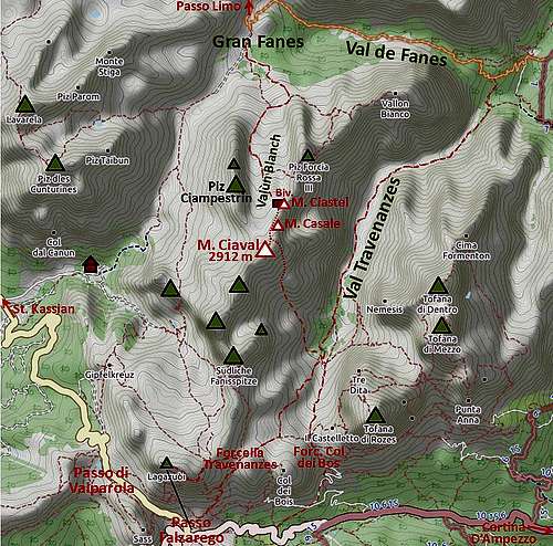
Tour start: Gran Fanes alpine pasture, 2102 m. See the main page of Monte Ciaval how to get there!
Highest point: 2912 m.
Altitude to overcome: cca 950 m from Gran Fanes. From Podestagno trailhead it's 1750 m.
Time for ascent: 3 h (5 h 30 min from Podestagno on the main road, 3 h 45 min from Rif. Fanes).
Map: Tabacco. Cortina d'Ampezzo e Dolomiti Ampezzane. 1:25000.
Route Description
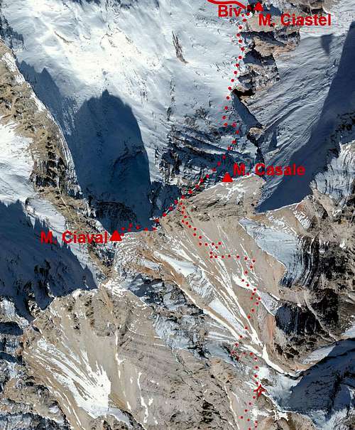
Already in the beginning from the red-marked path No. 17 the yellow-marked old path branches right (ciarn). That's the shortcut which can save you some 10 min, but we haven't tried it. The path No. 17 cotinues gently ascending towards the SE and is at first nice and broad - the ex military road. It goes over a nice karstic terrain winding gently up, until it reaches the rocky base of Furcia Rossa's side ridge (northern), on 2250 m. There's the path branching. The left branch goes to the entry of Via della Pace ferrata. Don't go there (unless you want to extend the tour much and later sleep in the bivouac), even if also there it says 'bivouac'. Take the right branch, which goes to the bivouac directly!
After a few minutes you find yourself on a nice valley barrier. From there the path descends left into a beautiful, grassy basin and then crosses it in the W-SW direction. Just before it reaches the slopes of Cime Ciampestrin, from the right the yellow-marked shortcut comes up.
 On Gran Fanes |  Towards Vallon Bianco |  Below Cime Ciampestrin |
Now the route goes up by the Valun Blanch, keeping right, just below the mighty walls of Cime Ciampestrin. The ascent is still comfortable, the ex mule track is winding up by a valley, filled with huge rock blocks. When the route exits the valley, we find ourselves on a slanted high plateau of the upper Valun Blanch. We are heading directly towards the distinct rock tower in the main ridge - Monte Ciastel, below which we see the wooden bivouac. In the last part the slope gets steeper, but in a few comfortable switchbacks we quickly gain it.
 Monte Castello |  Bivacco della Pace |  At Bivacco della Pace |
From the bivouac we continue right by a well cut, also marked ex military path. Here you can visit many caverns, if curious. Reaching the ridge base of Monte Casale, the path again starts ascending. There it is less evident and beaten, some care is needed before some 20 m higher the again better path is reached. We now ascend just below the summit of Monte Casale (easy rock climb to the top), but the path levels again and goes just below the main ridge towards Monte Ciaval. This part is very picturesque, but a bit exposed on a few places. Before reaching Monte Ciaval, there are a few ridge notches, where spectacular views on Tofane open. The Forcella Casale is clearly marked - to warn those who want to descend there!
 Monte Casale and Monte Ciaval |  Monte Ciaval |  The view on Tofane |
So we reach the base of Monte Ciaval. The final ascent goes up in quite steep switchbacks. The path is just wide enough to walk up carefully, but on some places friable rock and exposition require additional attention. The turns bring us just below the summit. There the path disappears a bit and we need to carefully cross a few meters to the left, on the NE ridge. There's the mark and the remaining meters of ascent are an easy walk up again.
Descent. You descend by the same route, or from Forcella Casale descend southwards, into Val Travenanzes. If having car near Podestagno, you continue down by the valley to that trailhead.