
-
 3752 Hits
-
 73.06% Score
-
 3 Votes
|
|
Route |
|---|---|
|
|
46.90560°N / 12.08440°E |
|
|
Mountaineering |
|
|
Spring, Summer, Fall |
|
|
Most of a day |
|
|
UIAA I |
|
|
Class 3 |
|
|
Rating the Route (by Hiking Standards)
 Bor - On the north ridge
0. General. 1580 m to 3358 m, exposition N. Below marked path, on the bottom part of the ridge protected by steel pegs and ropes, above easy rock climb and snowy/icy ridge.
1. Effort: 1800 m (from the parking place, 1100 m from the hut), 5 h 30 min.
2. Power: 2 - easy
3. Psyche: 3 - medium (if the ridge is icy, belaying recommended)
4. Orientation: 2 - easy
Approach
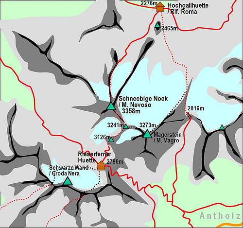 Schneebige Nock / Monte Nevoso and its routes
See the parent page of Schneebige Nock how to get in Rain village! You reach the Hochgallhuette, 2276 m from Bachertal (Saege parking place, 1580 m) in 2 hours.
Route Description
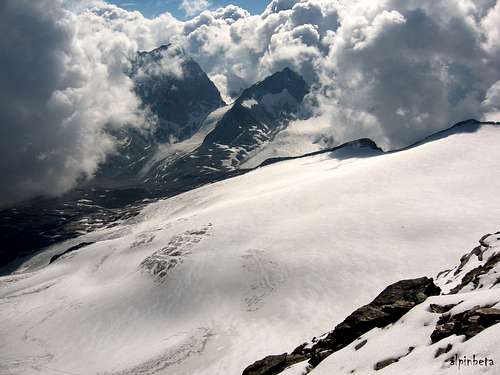 alpinbeta - The view from the normal ascent route
From the Hochgallhuette you ascend southwards some 40 meters and reach a beautiful grassy terrace, with water sources all around shelter rocks and great view on Hochgall and on the Durreck group on the other side of the valley. This place is a bit close to the hut but is wonderful for setting up a tent. Although a few people came by, we couldn't resist using it, so we slept there instead of using the hut. South of the hut and this nice place a sharp 150 m high peak is rising, called Tristennoeckl (2465 m).
For the Schneebige Nock / Monte Nevoso ascent we take the marked path No. 1, which crosses its western slopes. In some 20 minutes we reach the bottom of a shallow valley, and cross the creek, flowing from the Schneebige Nock Ferner (glacier). Although it seems that the ascent is possible also by the right part of the glacier (some 45 degrees?), marks take us up to the north ridge, where the first steep rocky section begins. Steel ropes and pegs help us to overcome the steepest first part of the ridge. Above this section the ridge becomes less steep, but higher rocks are mixed with snow and ice and we must put on crampons. So we continue comfortably by the middle part of the ridge. The last part is usually rocky again. We probably will not take off crampons so some sections over the rocky plates are a bit uncomfortable. But there are no real problems and after good 3 hours we stand on the highest point.
Essential Gear
Ice axe, crampons, eventually a short rope.