
-
 4886 Hits
-
 74.01% Score
-
 4 Votes
|
|
Route |
|---|---|
|
|
46.22085°N / 12.65084°E |
|
|
Hiking |
|
|
Summer, Fall |
|
|
Half a day |
|
|
Medium hard hike up |
|
|
Rating The Tour (By Hiking Standards)

Below Forcella Capra
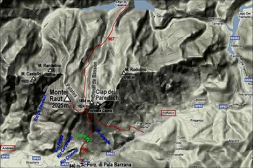
0. General. From 840 m to 2025 m, exposition S, E and N. All the time marked. Mostly a good path till ex Casera di Pala Barzana, then a weak, steep path over steep grassy slopes and along a scree ravine. In the upper part of Rio Grande ravine there's a rocky step where a few meters must be climbed (easy), but the passage is also secured by a thin cable. Then steep grassy slopes to the notch and a nice, not very exposed ridge towards the summit. Just before the summit there's another rocky section to be climbed (also easy and protected). By the Swiss (SAC) Hiking Scale the rating would be T3. Gear (in dry seasons): Only good shoes and poles.
1. Effort. 1200 m, 3 h 30 min.
2. Power. 2 - easy, on a few places some pulling up is needed.
3. Psyche. 3 - medium (only a few places, otherwise easy).
4. Orientation. 1 - no difficulties (all the time good marked paths). The grading system for hiking and scrambling routes is here.
Overview
This is a beautiful tour which enables to ascend by a medium hard hike up on one of the cardinal summits of Carnic Pre-Alps. The route is steep in the medium part, so altitude can be gained quickly. All the time the ascent is very panoramic. Due to the southern exposition the tour can be hot. Better take enough water with you, even if above Rio Grande ravine there's a water source. Great panorama from the top.
Getting There
Andreis and Poffabro are connected by a narrow asphalt road, crossing Forcella di Pala Barzana, 840 m. This saddle is the trailhead for our route.
Route Description

Start of the route
Just from the parking place on the saddle you go by the well marked path No. 967 towards the north. The inscription table by the road says it is 3 h 30 min to Forcella Capra, but that is much exaggerated. After a small meadow the path ascends steeply through the woods. In the middle of the slope go left - as the inscription "Cima della Bandiera" says. From the small hill with the Italian flag there is indeed a nice view towards the west.

Grassy slopes
In the next section, the path crosses the eastern scree slopes of the side ridge. The path is still good, but you will also find a few eroded places where some care is needed. Not much elevation will be gained in the next 20 minutes. After the crossing, the path enters a forrest again, in a good 15 minutes ascent we reach the ex alpine pasture and the ruins of Casera di Pala Barzana. Take care that you go before the hut by the marked path upwards, because the path which goes horizontally below the huts later descends into the valley towards Poffabro (a mountain run course).

Rio Grande sccree flow
After some 10 minutes of ascent we already reach out of the beech forrest. Till the main ridge we shall now be ascending over grassy slopes. The path first crosses towards the right. We go below a distinct maple tree which is especially beautiful in autumn colours. Behind a grassy edge we find ourselves in the ravine of Rio Grande. That's not a river, nor a creek, but a dry scree ravine which goes all the way up to the ridge. The path becomes a bit unpleasant as on a few places it goes up by soft scree fields. Otherwise we do most of the altitude by the left, western side of the ravine. It's almost 400 meters of such an ascent and you only think how pleasant it will be to slide down by those screes.

Clap del Paredach
Above, where the ravine ends, we already reach the rocky face of Monte Raut. Below the wall there is a small water source. In the continuation of the ravine we reach the rocky step, which we need to climb. It's only a few meters, rock is good, washed by water and there is also a thin steel cable for protection. Above, the steep ascent continues, first in the vicinity of the ravine, then we exit right on a grassy side ridge. On the place where we gain it, from the right the path from Pian delle Merie joins (inscriptions). Now we continue upwards by the ridge, cross again into a ravine right and soon exit on the main ridge, on Forcella Capra, 1824 m. The northern horizon opens.

Forcella Capra

On Forcella Capra
From Forcella Capra we see on the left (NW) already the summit. The path goes just by the ridge, a bit exposed on some places. Soon it reaches a horizontal part of the ridge, 1877 m. The next ridge elevation is detoured through bushes on the northern side (descending a little). On the other side the path goes up again, but before gaining the main ridge we need to climb over the last rocky step. On the right side of it pine bushes are growing and the passage is also protected by a thin steel cable. Some care is needed, but there are good holds in rocks and the passage is not very exposed. Above, the path ascends just below the ridge, on the northern side, but it is much nicer to go on top. From Forcella Capra to the highest point there's some 30 minutes.

The summit
We descend by the same route. Don't forget to use the whole long scree stream of Rio Grande ravine!
External Links
Monte Raut z juga - The page in Slovenian language on my personal web site.